- Cranbury Brook
-
Cranbury Brook 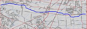
Map of Cranbury BrookOrigin 40°15′37″N 74°24′5″W / 40.26028°N 74.40139°W Mouth 40°19′26″N 74°36′47″W / 40.32389°N 74.61306°W Progression Millstone River, Raritan River, Atlantic Ocean Basin countries United States Mouth elevation 52 ft (16 m) Left tributaries Cedar Brook The Cranbury Brook, also known as the Cranberry Brook[1], is a tributary of the Millstone River found in central New Jersey, United States. It spans areas in Middlesex and Monmouth counties.
Contents
Course
The Cranbury Brook starts at 40°15′37″N 74°24′5″W / 40.26028°N 74.40139°W[1], near the intersection of SR-33, Dugans Grove Road, and Iron Ore Road. It flows westward, crossing Perrineville Road. It receives several tributaries from the area and crosses Union Valley Road and Applegarth Road. It then crosses the New Jersey Turnpike, and is dammed to form Brainerd Lake. As a lake it crosses Route 130 and South Main Street in the town of Cranbury. It continues flowing west through the Cranbury Preserve and receives the Cedar Brook. It then crosses George Davison Ave and forms another dammed section called the Plainsboro Pond. It then crosses Maple Ave and drains into the Millstone River at 40°19′26″N 74°36′47″W / 40.32389°N 74.61306°W[1].
Accessibility
The Cranbury Brook is easily accessed by the many roads that cross it, as well as its dammed sections such as the Brainerd Lake.
Sister tributaries
- Beden Brook
- Bear Brook
- Devils Brook
- Harrys Brook
- Heathcote Brook
- Indian Run Brook
- Little Bear Brook
- Millstone Brook
- Peace Brook
- Rocky Brook
- Royce Brook
- Simonson Brook
- Six Mile Run
- Stony Brook
- Ten Mile Run
- Van Horn Brook
See also
References
- ^ a b c "GNIS Detail - Cranbury Brook". USGS. http://gnis.usgs.gov/pls/gnispublic/f?p=139:3:1391459736175526::NO:3:P3_FID,P3_TITLE:875705%2CCranbury%20Brook. Retrieved 20 July 2010.
External links
Categories:- Rivers of New Jersey
- Tributaries of the Raritan River
- Geography of Middlesex County, New Jersey
- Geography of Monmouth County, New Jersey

Wikimedia Foundation. 2010.