- Cozahome, Arkansas
-
Cozahome, Arkansas — Unincorporated community — 
 Cozahome, Arkansas
Coordinates: 36°02′42″N 92°30′06″W / 36.045°N 92.50167°WCoordinates: 36°02′42″N 92°30′06″W / 36.045°N 92.50167°W Country United States State Arkansas County Searcy Elevation 1,204 ft (367 m) Time zone Central (CST) (UTC-6) - Summer (DST) CDT (UTC-5) Area code(s) 870 GNIS feature ID 57596[1] Cozahome is an unincorporated community in Searcy County, Arkansas, United States. Cozahome is 12 miles (19 km) northeast of Marshall.
Closest major highway
 Highway 14
Although Arkansas Highway 14 is not in Cozahome, it is the closest major highway to the community.
References
Municipalities and communities of Searcy County, Arkansas County seat: Marshall Cities 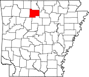
Towns Unincorporated
communitiesCozahome | Harriet | Snowball | Witts Springs
Footnotes ‡This populated place also has portions in an adjacent county or counties
Categories:- Populated places in Searcy County, Arkansas
- Unincorporated communities in Arkansas
- Arkansas geography stubs


Wikimedia Foundation. 2010.