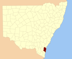
Dampier County

Dampier County
Dampier
New South Wales
Dampier NSW.PNG
Location in New South Wales
Lands administrative divisions around Dampier
Murray St. Vincent Pacific Ocean
Beresford Dampier Pacific Ocean
Auckland Auckland Pacific Ocean

Dampier County is one of the 141 Cadastral divisions of New South Wales. The Deua River is the northern boundary, with land slightly to the north of the Brogo River the southern boundary. It includes Bermagui, Narooma, Bodalla, and most of the Deua National Park and Wadbilliga National Park.

Dampier County was named in honour of seaman William Dampier (1651-1715), Seaman.[1]

Parishes within this county

A full list of parishes found within this county; their current LGA and mapping coordinates to the approximate centre of each location is as follows:

Parish LGA Coordinates
Badja Eurobodalla Shire 36°03′54″S 149°36′04″E / 36.065°S 149.60111°E / -36.065; 149.60111 (Badja Parish)
Belowra Eurobodalla Shire 36°08′54″S 149°43′04″E / 36.14833°S 149.71778°E / -36.14833; 149.71778 (Belowra Parish)
Bergalia Eurobodalla Shire 35°58′54″S 150°02′04″E / 35.98167°S 150.03444°E / -35.98167; 150.03444 (Bergalia Parish)
Bermagui Bega Valley Shire 36°24′54″S 150°00′04″E / 36.415°S 150.00111°E / -36.415; 150.00111 (Bermagui Parish)
Bodalla Eurobodalla Shire 36°06′54″S 150°04′04″E / 36.115°S 150.06778°E / -36.115; 150.06778 (Bodalla Parish)
Bumbo Eurobodalla Shire 36°03′54″S 150°00′04″E / 36.065°S 150.00111°E / -36.065; 150.00111 (Bumbo Parish)
Bumbo West Eurobodalla Shire 36°00′54″S 149°51′04″E / 36.015°S 149.85111°E / -36.015; 149.85111 (Bumbo West Parish)
Burra Eurobodalla Shire 35°53′54″S 149°57′04″E / 35.89833°S 149.95111°E / -35.89833; 149.95111 (Burra Parish)
Cadgee Eurobodalla Shire 36°10′54″S 149°51′04″E / 36.18167°S 149.85111°E / -36.18167; 149.85111 (Cadgee Parish)
Cadjangarry Bega Valley Shire 36°27′54″S 149°56′04″E / 36.465°S 149.93444°E / -36.465; 149.93444 (Cadjangarry Parish)
Congo Eurobodalla Shire 35°58′54″S 150°07′04″E / 35.98167°S 150.11778°E / -35.98167; 150.11778 (Congo Parish)
Coondella Eurobodalla Shire 35°57′54″S 149°48′04″E / 35.965°S 149.80111°E / -35.965; 149.80111 (Coondella Parish)
Countegany Cooma-Monaro Shire 36°18′54″S 149°35′04″E / 36.315°S 149.58444°E / -36.315; 149.58444 (Countegany Parish)
Curmulee Eurobodalla Shire 35°49′54″S 149°45′04″E / 35.83167°S 149.75111°E / -35.83167; 149.75111 (Curmulee Parish)
Currambene Palerang Council 35°56′54″S 149°34′04″E / 35.94833°S 149.56778°E / -35.94833; 149.56778 (Currambene Parish)
Deua Eurobodalla Shire 35°53′54″S 149°49′04″E / 35.89833°S 149.81778°E / -35.89833; 149.81778 (Deua Parish)
Dolondundale Cooma-Monaro Shire 36°18′54″S 149°28′04″E / 36.315°S 149.46778°E / -36.315; 149.46778 (Dolondundale Parish)
Donovan Eurobodalla Shire 35°49′54″S 149°56′04″E / 35.83167°S 149.93444°E / -35.83167; 149.93444 (Donovan Parish)
Eurobodalla Eurobodalla Shire 36°12′54″S 149°55′04″E / 36.215°S 149.91778°E / -36.215; 149.91778 (Eurobodalla Parish)
Guinea Cooma-Monaro Shire 36°11′54″S 149°32′04″E / 36.19833°S 149.53444°E / -36.19833; 149.53444 (Guinea Parish)
Gulph Eurobodalla Shire 36°04′54″S 149°51′04″E / 36.08167°S 149.85111°E / -36.08167; 149.85111 (Gulph Parish)
Jillaga Palerang Council 36°00′54″S 149°38′04″E / 36.015°S 149.63444°E / -36.015; 149.63444 (Jillaga Parish)
Jinden Cooma-Monaro Shire 35°51′54″S 149°33′04″E / 35.865°S 149.55111°E / -35.865; 149.55111 (Jinden Parish)
Merricumbene Eurobodalla Shire 35°45′54″S 149°51′04″E / 35.765°S 149.85111°E / -35.765; 149.85111 (Merricumbene Parish)
Moruya Eurobodalla Shire 35°55′54″S 150°06′04″E / 35.93167°S 150.10111°E / -35.93167; 150.10111 (Moruya Parish)
Murrabrine Bega Valley Shire 36°25′54″S 149°49′04″E / 36.43167°S 149.81778°E / -36.43167; 149.81778 (Murrabrine Parish)
Murrah Bega Valley Shire 36°31′54″S 150°00′04″E / 36.53167°S 150.00111°E / -36.53167; 150.00111 (Murrah Parish)
Narira Bega Valley Shire 36°23′54″S 149°54′04″E / 36.39833°S 149.90111°E / -36.39833; 149.90111 (Narira Parish)
Narooma Eurobodalla Shire 36°14′54″S 150°04′04″E / 36.24833°S 150.06778°E / -36.24833; 150.06778 (Narooma Parish)
Nerrigundah Eurobodalla Shire 36°06′54″S 150°00′04″E / 36.115°S 150.00111°E / -36.115; 150.00111 (Nerrigundah Parish)
Shoalhaven Palerang Council 35°55′54″S 149°38′04″E / 35.93167°S 149.63444°E / -35.93167; 149.63444 (Shoalhaven Parish)
Tanja Bega Valley Shire 36°35′54″S 150°00′04″E / 36.59833°S 150.00111°E / -36.59833; 150.00111 (Tanja Parish)
Uranbene Eurobodalla Shire 35°58′54″S 149°43′04″E / 35.98167°S 149.71778°E / -35.98167; 149.71778 (Uranbene Parish)
Wadbilliga Bega Valley Shire 36°11′54″S 149°36′04″E / 36.19833°S 149.60111°E / -36.19833; 149.60111 (Wadbilliga Parish)
Wadbilliga West Bega Valley Shire 36°14′09″S 149°35′27″E / 36.23583°S 149.59083°E / -36.23583; 149.59083 (Wadbilliga West Parish)
Wagonga Eurobodalla Shire 36°11′54″S 150°05′04″E / 36.19833°S 150.08444°E / -36.19833; 150.08444 (Wagonga Parish)
Wamban Eurobodalla Shire 35°57′54″S 149°57′04″E / 35.965°S 149.95111°E / -35.965; 149.95111 (Wamban Parish)
Wandella Bega Valley Shire 36°17′54″S 149°52′04″E / 36.29833°S 149.86778°E / -36.29833; 149.86778 (Wandella Parish)
Wapengo Bega Valley Shire 36°33′54″S 149°55′04″E / 36.565°S 149.91778°E / -36.565; 149.91778 (Wapengo Parish)
Wyanbene Eurobodalla Shire 35°46′54″S 149°44′04″E / 35.78167°S 149.73444°E / -35.78167; 149.73444 (Wyanbene Parish)
Yowrie Bega Valley Shire 36°19′54″S 149°45′04″E / 36.33167°S 149.75111°E / -36.33167; 149.75111 (Yowrie Parish)

References


Wikimedia Foundation. 2010.

Игры ⚽ Поможем написать реферат

Look at other dictionaries:

  • Dampier County, New South Wales — Infobox Australian cadastral name = Dampier state = New South Wales caption = Location in New South Wales near nw = Murray near n = St. Vincent near ne = Pacific Ocean near e = Pacific Ocean near se = Pacific Ocean near s = Auckland near sw =… …   Wikipedia

  • Erick Dampier — Pour les articles homonymes, voir Dampier. Erick Dampier …   Wikipédia en Français

  • Murray County, New South Wales — Map of all coordinates from Google Map of all coordinates from Bing Export all coordinates as KML …   Wikipedia

  • St. Vincent County, New South Wales — Infobox Australian cadastral name = St. Vincent state = New South Wales caption = Location in New South Wales near nw = Argyle near n = Camden near ne = Camden near w = Murray near e = Pacific Ocean near sw = Murray near s = Dampier near se =… …   Wikipedia

  • Beresford County, New South Wales — Infobox Australian cadastral name = Beresford state = New South Wales caption = Location in New South Wales near nw = Cowley near n = Murray near ne = Murray near w = Wallace near e = Dampier near sw = Wallace near s = Wellesley near se =… …   Wikipedia

  • Auckland County, New South Wales — Infobox Australian cadastral name = Auckland state = New South Wales caption = Location in New South Wales near nw = Beresford near n = Dampier near ne = Pacific Ocean near w = Wellesley near e = Pacific Ocean near sw = Croajingolong (Vic) near s …   Wikipedia

  • Auckland County — Map of all coordinates from Google Map of all coordinates from Bing Export all coordinates as KML …   Wikipedia

  • Beresford County — Map of all coordinates from Google Map of all coordinates from Bing Export all coordinates as KML …   Wikipedia

  • St Vincent County — Map of all coordinates from Google Map of all coordinates from Bing Export all coordinates as KML …   Wikipedia

  • Nottingham Panthers — City Nottingham, England League Elite Ice Hockey League …   Wikipedia

Share the article and excerpts

Direct link
Do a right-click on the link above
and select “Copy Link”