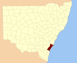
St Vincent County

St Vincent County
St. Vincent
New South Wales
St vincent NSW.PNG
Location in New South Wales
Lands administrative divisions around St. Vincent
Argyle Camden Camden
Murray St. Vincent Pacific Ocean
Murray Dampier Pacific Ocean

St Vincent County was one of the original Nineteen Counties in New South Wales and is now one of the 141 Cadastral divisions of New South Wales. It included the south coast area encompassing Batemans Bay, Ulladulla, Jervis Bay and inland to Braidwood. The Shoalhaven River is the boundary to the north and west, and the Deua River the boundary to the south.

St. Vincent County was named in honour of John Jervis, 1st Earl of St Vincent (1735-1823), Admiral of the Fleet.[1] The electoral district of United Counties of Murray and St Vincent and the electoral district of St Vincent were the first electoral districts for the area, between 1856 and 1859.

In 1852 it had an area of 1,704,844 acres (6,899.26 km2) and population of 2,572. [2]

Parishes within this county

Land in the Parishes of Bherwerre, Beecroft, Farnham and Nowra was transferred to the Commonwealth government in 1915 to become the Jervis Bay Territory, as specified in the Seat of Government Acceptance Act 1909. A full list of parishes found within this county; their current LGA and mapping coordinates to the approximate centre of each location is as follows:

Parish LGA Coordinates
Albert City of Shoalhaven 35°30′54″S 150°15′04″E / 35.515°S 150.25111°E / -35.515; 150.25111 (Albert Parish)
Araluen Palerang Council 35°37′54″S 149°48′04″E / 35.63167°S 149.80111°E / -35.63167; 149.80111 (Araluen Parish)
Bateman Eurobodalla Shire 35°45′54″S 150°12′04″E / 35.765°S 150.20111°E / -35.765; 150.20111 (Bateman Parish)
Beecroft City of Shoalhaven 35°01′54″S 150°49′04″E / 35.03167°S 150.81778°E / -35.03167; 150.81778 (Beecroft Parish)
Benandarah Eurobodalla Shire 35°39′54″S 150°16′04″E / 35.665°S 150.26778°E / -35.665; 150.26778 (Benandarah Parish)
Bendoura Palerang Council 35°30′54″S 149°42′04″E / 35.515°S 149.70111°E / -35.515; 149.70111 (Bendoura Parish)
Bettowynd Palerang Council 35°42′54″S 149°46′04″E / 35.715°S 149.76778°E / -35.715; 149.76778 (Bettowynd Parish)
Bherwerre City of Shoalhaven 35°08′54″S 150°45′04″E / 35.14833°S 150.75111°E / -35.14833; 150.75111 (Bherwerre Parish)
Bolaro Eurobodalla Shire 35°39′54″S 150°00′04″E / 35.665°S 150.00111°E / -35.665; 150.00111 (Bolaro Parish)
Boolijah City of Shoalhaven 35°02′54″S 150°21′04″E / 35.04833°S 150.35111°E / -35.04833; 150.35111 (Boolijah Parish)
Borimbadal City of Shoalhaven 34°52′54″S 150°08′04″E / 34.88167°S 150.13444°E / -34.88167; 150.13444 (Borimbadal Parish)
Boyle Palerang Council 35°29′54″S 149°45′04″E / 35.49833°S 149.75111°E / -35.49833; 149.75111 (Boyle Parish)
Boyne City of Shoalhaven 35°25′54″S 150°17′04″E / 35.43167°S 150.28444°E / -35.43167; 150.28444 (Boyne Parish)
Braidwood Palerang Council 35°24′54″S 149°51′04″E / 35.415°S 149.85111°E / -35.415; 149.85111 (Braidwood Parish)
Broulee Eurobodalla Shire 35°50′54″S 150°10′04″E / 35.84833°S 150.16778°E / -35.84833; 150.16778 (Broulee Parish)
Bruce Palerang Council 35°21′54″S 149°45′04″E / 35.365°S 149.75111°E / -35.365; 149.75111 (Bruce Parish)
Buangla City of Shoalhaven 34°54′54″S 150°27′04″E / 34.915°S 150.45111°E / -34.915; 150.45111 (Buangla Parish)
Buckenbowra Eurobodalla Shire 35°44′54″S 150°00′04″E / 35.74833°S 150.00111°E / -35.74833; 150.00111 (Buckenbowra Parish)
Budawang City of Shoalhaven 35°26′54″S 149°58′04″E / 35.44833°S 149.96778°E / -35.44833; 149.96778 (Budawang Parish)
Bulee City of Shoalhaven 34°59′54″S 150°08′04″E / 34.99833°S 150.13444°E / -34.99833; 150.13444 (Bulee Parish)
Burrill City of Shoalhaven 35°20′54″S 150°06′04″E / 35.34833°S 150.10111°E / -35.34833; 150.10111 (Burrill Parish)
Clyde Eurobodalla Shire 35°34′54″S 150°13′04″E / 35.58167°S 150.21778°E / -35.58167; 150.21778 (Clyde Parish)
Coghill Palerang Council 35°29′54″S 149°50′04″E / 35.49833°S 149.83444°E / -35.49833; 149.83444 (Coghill Parish)
Conjola City of Shoalhaven 35°14′54″S 150°27′04″E / 35.24833°S 150.45111°E / -35.24833; 150.45111 (Conjola Parish)
Coolumburra City of Shoalhaven 35°02′54″S 150°06′04″E / 35.04833°S 150.10111°E / -35.04833; 150.10111 (Coolumburra Parish)
Corang Palerang Council 35°12′54″S 150°07′04″E / 35.215°S 150.11778°E / -35.215; 150.11778 (Corang Parish)
Croobyar City of Shoalhaven 35°21′54″S 150°18′04″E / 35.365°S 150.30111°E / -35.365; 150.30111 (Croobyar Parish)
Cudmirrah City of Shoalhaven 35°10′54″S 150°30′04″E / 35.18167°S 150.50111°E / -35.18167; 150.50111 (Cudmirrah Parish)
Currambene City of Shoalhaven 34°58′54″S 150°39′04″E / 34.98167°S 150.65111°E / -34.98167; 150.65111 (Currambene Parish)
Currock City of Shoalhaven 35°27′54″S 150°05′04″E / 35.465°S 150.08444°E / -35.465; 150.08444 (Currock Parish)
Currowan Eurobodalla Shire 35°34′54″S 150°07′04″E / 35.58167°S 150.11778°E / -35.58167; 150.11778 (Currowan Parish)
Danjera City of Shoalhaven 34°57′54″S 150°22′04″E / 34.965°S 150.36778°E / -34.965; 150.36778 (Danjera Parish)
Durran Durra Palerang Council 35°21′54″S 149°52′04″E / 35.365°S 149.86778°E / -35.365; 149.86778 (Durran Durra Parish)
East Nelligen Eurobodalla Shire 35°39′54″S 150°11′04″E / 35.665°S 150.18444°E / -35.665; 150.18444 (East Nelligen Parish)
Elrington Palerang Council 35°32′54″S 149°45′04″E / 35.54833°S 149.75111°E / -35.54833; 149.75111 (Elrington Parish)
Endrick City of Shoalhaven 35°14′54″S 150°14′04″E / 35.24833°S 150.23444°E / -35.24833; 150.23444 (Endrick Parish)
Ettrema City of Shoalhaven 34°57′54″S 150°14′04″E / 34.965°S 150.23444°E / -34.965; 150.23444 (Ettrema Parish)
Farnham City of Shoalhaven 35°07′54″S 150°30′04″E / 35.13167°S 150.50111°E / -35.13167; 150.50111 (Farnham Parish)
Goba Eurobodalla Shire 35°44′54″S 150°08′04″E / 35.74833°S 150.13444°E / -35.74833; 150.13444 (Goba Parish)
Jerrawangala City of Shoalhaven 35°03′54″S 150°27′04″E / 35.065°S 150.45111°E / -35.065; 150.45111 (Jerrawangala Parish)
Jerricknorra Palerang Council 35°10′54″S 150°00′04″E / 35.18167°S 150.00111°E / -35.18167; 150.00111 (Jerricknorra Parish)
Kioloa City of Shoalhaven 35°34′54″S 150°19′04″E / 35.58167°S 150.31778°E / -35.58167; 150.31778 (Kioloa Parish)
Little Forest City of Shoalhaven 35°14′54″S 150°20′04″E / 35.24833°S 150.33444°E / -35.24833; 150.33444 (Little Forest Parish)
Marlowe Palerang Council 35°15′54″S 149°52′04″E / 35.265°S 149.86778°E / -35.265; 149.86778 (Marlowe Parish)
Meangora Palerang Council 35°04′54″S 150°00′04″E / 35.08167°S 150.00111°E / -35.08167; 150.00111 (Meangora Parish)
Milo Eurobodalla Shire 35°40′54″S 149°54′04″E / 35.68167°S 149.90111°E / -35.68167; 149.90111 (Milo Parish)
Mogendoura Eurobodalla Shire 35°51′54″S 150°01′04″E / 35.865°S 150.01778°E / -35.865; 150.01778 (Mogendoura Parish)
Mogood City of Shoalhaven 35°28′54″S 150°11′04″E / 35.48167°S 150.18444°E / -35.48167; 150.18444 (Mogood Parish)
Monga Palerang Council 35°29′54″S 149°56′04″E / 35.49833°S 149.93444°E / -35.49833; 149.93444 (Monga Parish)
Mongarlowe Palerang Council 35°20′54″S 150°00′04″E / 35.34833°S 150.00111°E / -35.34833; 150.00111 (Mongarlowe Parish)
Mullendaree Eurobodalla Shire 35°48′54″S 150°03′04″E / 35.815°S 150.05111°E / -35.815; 150.05111 (Mullendaree Parish)
Murrengenburg City of Shoalhaven 35°32′54″S 150°00′04″E / 35.54833°S 150.00111°E / -35.54833; 150.00111 (Murrengenburg Parish)
Nowra City of Shoalhaven 34°53′54″S 150°30′04″E / 34.89833°S 150.50111°E / -34.89833; 150.50111 (Nowra Parish)
Numbaa City of Shoalhaven 34°53′54″S 150°40′04″E / 34.89833°S 150.66778°E / -34.89833; 150.66778 (Numbaa Parish)
Percy Palerang Council 35°22′54″S 149°45′04″E / 35.38167°S 149.75111°E / -35.38167; 149.75111 (Percy Parish)
Quiera City of Shoalhaven 34°56′24″S 150°12′04″E / 34.94°S 150.20111°E / -34.94; 150.20111 (Quiera Parish)
Sassafras City of Shoalhaven 35°07′54″S 150°13′04″E / 35.13167°S 150.21778°E / -35.13167; 150.21778 (Sassafras Parish)
Seymour Palerang Council 35°33′54″S 149°50′04″E / 35.565°S 149.83444°E / -35.565; 149.83444 (Seymour Parish)
St. George City of Shoalhaven 34°59′54″S 150°13′04″E / 34.99833°S 150.21778°E / -34.99833; 150.21778 (St. George Parish)
Tallaganda Palerang Council 35°39′54″S 149°41′04″E / 35.665°S 149.68444°E / -35.665; 149.68444 (Tallaganda Parish)
Tallowal City of Shoalhaven 34°52′54″S 150°13′04″E / 34.88167°S 150.21778°E / -34.88167; 150.21778 (Tallowal Parish)
Termeil City of Shoalhaven 35°28′54″S 150°21′04″E / 35.48167°S 150.35111°E / -35.48167; 150.35111 (Termeil Parish)
Tianjara City of Shoalhaven 35°08′54″S 150°21′04″E / 35.14833°S 150.35111°E / -35.14833; 150.35111 (Tianjara Parish)
Tomaga Eurobodalla Shire 35°51′54″S 150°07′04″E / 35.865°S 150.11778°E / -35.865; 150.11778 (Tomaga Parish)
Tomboye Palerang Council 35°14′54″S 149°57′04″E / 35.24833°S 149.95111°E / -35.24833; 149.95111 (Tomboye Parish)
Tomerong City of Shoalhaven 34°58′54″S 150°29′04″E / 34.98167°S 150.48444°E / -34.98167; 150.48444 (Tomerong Parish)
Touga City of Shoalhaven 34°54′54″S 150°07′04″E / 34.915°S 150.11778°E / -34.915; 150.11778 (Touga Parish)
Ulladulla City of Shoalhaven 35°19′54″S 150°27′04″E / 35.33167°S 150.45111°E / -35.33167; 150.45111 (Ulladulla Parish)
Wandrawandian City of Shoalhaven 35°03′54″S 150°33′04″E / 35.065°S 150.55111°E / -35.065; 150.55111 (Wandrawandian Parish)
West Nelligen Eurobodalla Shire 35°40′54″S 150°05′04″E / 35.68167°S 150.08444°E / -35.68167; 150.08444 (West Nelligen Parish)
Wog Wog Palerang Council 35°15′54″S 150°02′04″E / 35.265°S 150.03444°E / -35.265; 150.03444 (Wog Wog Parish)
Wollumboola City of Shoalhaven 34°57′54″S 150°44′04″E / 34.965°S 150.73444°E / -34.965; 150.73444 (Wollumboola Parish)
Woodburn City of Shoalhaven 35°23′54″S 150°23′04″E / 35.39833°S 150.38444°E / -35.39833; 150.38444 (Woodburn Parish)
Yadboro City of Shoalhaven 35°22′54″S 150°13′04″E / 35.38167°S 150.21778°E / -35.38167; 150.21778 (Yadboro Parish)
Yalwal City of Shoalhaven 34°52′54″S 150°19′04″E / 34.88167°S 150.31778°E / -34.88167; 150.31778 (Yalwal Parish)
Yerriyong City of Shoalhaven 34°57′54″S 150°27′04″E / 34.965°S 150.45111°E / -34.965; 150.45111 (Yerriyong Parish)

References

  1. ^ Geographical Names Board of NSW
  2. ^ "Old Welsh Books with English Translations", The Land of Gold: the Companion for the Welsh Emigrant to Australia, 1852

Wikimedia Foundation. 2010.

Игры ⚽ Поможем написать курсовую

Look at other dictionaries:

  • St. Vincent County, New South Wales — Infobox Australian cadastral name = St. Vincent state = New South Wales caption = Location in New South Wales near nw = Argyle near n = Camden near ne = Camden near w = Murray near e = Pacific Ocean near sw = Murray near s = Dampier near se =… …   Wikipedia

  • Vincent Pyke — (4 February 1827 – 5 June 1894) was a 19th century politician in Otago, New Zealand and Castlemaine, Victoria, Australia. He was born in Somerset, England and went to Australia in 1851, first South Australia and then the gold diggings in Victoria …   Wikipedia

  • Vincent (Kalifornien) — Vincent …   Deutsch Wikipedia

  • Vincent DiMartino — is most commonly known for his work at Orange County Choppers (OCC), the subject of the American TV show American Chopper from 2002 to 2007. In August 2007 Vinnie left Orange County Choppers and founded V Force Customs, a custom motorcycle shop… …   Wikipedia

  • Vincent DeSimone — Vincent J. DeSimone, Jr. (1918 ndash; 1979) was the Chief of Detectives of Passaic County, New Jersey, USA. In 1966, he became known as the lead detective in the homicide case at Lafayette Grill, Paterson, New Jersey. His handling of eyewitnesses …   Wikipedia

  • Vincent F. Harrington — Vincent Francis Harrington (May 16, 1903 November 29, 1943) was a Democratic U.S. Representative from Iowa. Harrington enlisted in the United States Army Air Corps after the Pearl Harbor attack, resigned from Congress when President Franklin D.… …   Wikipedia

  • Vincent Gigante — Vincent Louis Gigante Vincent Gigante in 1957. Born March 29, 1928(1928 03 29) Manhattan, New York, U.S. Died …   Wikipedia

  • Vincent Bugliosi — (IPAEng|ˌbuːliˈoʊsi, with a silent g) (born August 18, 1934, in Hibbing, Minnesota) is an American attorney and author, best known for prosecuting Charles Manson and other defendants accused of the Tate LaBianca murders. His most recent books are …   Wikipedia

  • Vincent D'Onofrio — D Onofrio en el Festival de cine de Tribeca (mayo de 2008) Nombre real Vincent Phillip D Onofrio Nacimiento …   Wikipedia Español

  • Vincent DiMartino — Naissance 9 octobre 1972 (1972 10 09) (39 ans) Vallée de l Hudson, New York Nationalité Américain Pays de résidence États Unis Activité principale …   Wikipédia en Français

Share the article and excerpts

Direct link
Do a right-click on the link above
and select “Copy Link”