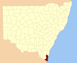
Auckland County

Auckland County
Auckland
New South Wales
Auckland NSW.PNG
Location in New South Wales
Lands administrative divisions around Auckland
Beresford Dampier Pacific Ocean
Wellesley Auckland Pacific Ocean
Croajingolong (Vic) Croajingolong (Vic) Pacific Ocean

Auckland County is one of the 141 Cadastral divisions of New South Wales. It is at the extreme south-east of the state, with the Victorian border to the south, and the area to the north of the Brogo River the boundary to the north. It includes Bega, Eden and Merimbula.

Auckland County was named in honour of George Eden, who was the First Earl of Auckland between (1784-1849).[1]

In 1852 it had an area of 1,536,000 acres (6,220 km2) and was described as being mountainous with fertile plains.[2]

Parishes within this county

A full list of parishes found within this county; their current LGA and mapping coordinates to the approximate centre of each location is as follows:

Parish LGA Coordinates
Bega Bega Valley Shire 36°40′54″S 149°54′04″E / 36.68167°S 149.90111°E / -36.68167; 149.90111 (Bega Parish)
Bemboka Bega Valley Shire 36°40′54″S 149°37′04″E / 36.68167°S 149.61778°E / -36.68167; 149.61778 (Bemboka Parish)
Bimmil Bega Valley Shire 36°59′54″S 149°50′04″E / 36.99833°S 149.83444°E / -36.99833; 149.83444 (Bimmil Parish)
Bondi Bombala Shire 37°06′54″S 149°15′04″E / 37.115°S 149.25111°E / -37.115; 149.25111 (Bondi Parish)
Bournda Bega Valley Shire 36°48′54″S 149°55′04″E / 36.815°S 149.91778°E / -36.815; 149.91778 (Bournda Parish)
Boyd Bega Valley Shire 37°00′54″S 149°43′04″E / 37.015°S 149.71778°E / -37.015; 149.71778 (Boyd Parish)
Bredbendoura Bega Valley Shire 36°45′54″S 149°30′04″E / 36.765°S 149.50111°E / -36.765; 149.50111 (Bredbendoura Parish)
Brogo Bega Valley Shire 36°37′54″S 149°51′04″E / 36.63167°S 149.85111°E / -36.63167; 149.85111 (Brogo Parish)
Bronte Bega Valley Shire 36°34′54″S 149°45′04″E / 36.58167°S 149.75111°E / -36.58167; 149.75111 (Bronte Parish)
Buckle Bega Valley Shire 37°18′54″S 149°41′04″E / 37.315°S 149.68444°E / -37.315; 149.68444 (Buckle Parish)
Burragate Bega Valley Shire 36°58′54″S 149°38′04″E / 36.98167°S 149.63444°E / -36.98167; 149.63444 (Burragate Parish)
Candelo Bega Valley Shire 36°43′54″S 149°45′04″E / 36.73167°S 149.75111°E / -36.73167; 149.75111 (Candelo Parish)
Cobra Bega Valley Shire 36°53′54″S 149°47′04″E / 36.89833°S 149.78444°E / -36.89833; 149.78444 (Cobra Parish)
Colombo Bega Valley Shire 36°33′54″S 149°26′04″E / 36.565°S 149.43444°E / -36.565; 149.43444 (Colombo Parish)
Coolangubra Bega Valley Shire 36°59′54″S 149°30′04″E / 36.99833°S 149.50111°E / -36.99833; 149.50111 (Coolangubra Parish)
Eden Bega Valley Shire 37°03′54″S 149°51′04″E / 37.065°S 149.85111°E / -37.065; 149.85111 (Eden Parish)
Genoa Bombala Shire 37°08′54″S 149°25′04″E / 37.14833°S 149.41778°E / -37.14833; 149.41778 (Genoa Parish)
Gnupa Bega Valley Shire 36°57′54″S 149°47′04″E / 36.965°S 149.78444°E / -36.965; 149.78444 (Gnupa Parish)
Gooyan Bega Valley Shire 37°14′54″S 149°47′04″E / 37.24833°S 149.78444°E / -37.24833; 149.78444 (Gooyan Parish)
Howe Bega Valley Shire 37°21′54″S 149°56′04″E / 37.365°S 149.93444°E / -37.365; 149.93444 (Howe Parish)
Imlay Bega Valley Shire 37°04′54″S 149°44′04″E / 37.08167°S 149.73444°E / -37.08167; 149.73444 (Imlay Parish)
Kameruka Bega Valley Shire 36°44′54″S 149°50′04″E / 36.74833°S 149.83444°E / -36.74833; 149.83444 (Kameruka Parish)
Kanoonah Bega Valley Shire 36°55′54″S 149°25′04″E / 36.93167°S 149.41778°E / -36.93167; 149.41778 (Kanoonah Parish)
Kiah Bega Valley Shire 37°07′54″S 149°56′04″E / 37.13167°S 149.93444°E / -37.13167; 149.93444 (Kiah Parish)
Kokoboreeka Bega Valley Shire 36°23′54″S 149°35′04″E / 36.39833°S 149.58444°E / -36.39833; 149.58444 (Kokoboreeka Parish)
Mataganah Bega Valley Shire 36°58′54″S 149°34′04″E / 36.98167°S 149.56778°E / -36.98167; 149.56778 (Mataganah Parish)
Meringo Bega Valley Shire 36°41′54″S 149°46′04″E / 36.69833°S 149.76778°E / -36.69833; 149.76778 (Meringo Parish)
Mogila Bega Valley Shire 36°41′54″S 149°30′04″E / 36.69833°S 149.50111°E / -36.69833; 149.50111 (Mogila Parish)
Mokoreeka Bega Valley Shire 36°27′54″S 149°31′04″E / 36.465°S 149.51778°E / -36.465; 149.51778 (Mokoreeka Parish)
Mookerwah Bega Valley Shire 36°24′54″S 149°43′04″E / 36.415°S 149.71778°E / -36.415; 149.71778 (Mookerwah Parish)
Mumbulla Bega Valley Shire 36°29′54″S 149°48′04″E / 36.49833°S 149.80111°E / -36.49833; 149.80111 (Mumbulla Parish)
Nalbaugh Bega Valley Shire 37°03′54″S 149°23′04″E / 37.065°S 149.38444°E / -37.065; 149.38444 (Nalbaugh Parish)
Narrabarba Bega Valley Shire 37°15′54″S 149°53′04″E / 37.265°S 149.88444°E / -37.265; 149.88444 (Narrabarba Parish)
Nullica Bega Valley Shire 37°07′54″S 149°49′04″E / 37.13167°S 149.81778°E / -37.13167; 149.81778 (Nullica Parish)
Numbugga Bega Valley Shire 36°38′54″S 149°46′04″E / 36.64833°S 149.76778°E / -36.64833; 149.76778 (Numbugga Parish)
Nungatta Bega Valley Shire 37°12′54″S 149°27′04″E / 37.215°S 149.45111°E / -37.215; 149.45111 (Nungatta Parish)
Ooranook Bega Valley Shire 36°33′54″S 149°34′04″E / 36.565°S 149.56778°E / -36.565; 149.56778 (Ooranook Parish)
Pambula Bega Valley Shire 36°52′54″S 149°54′04″E / 36.88167°S 149.90111°E / -36.88167; 149.90111 (Pambula Parish)
Pericoe Bega Valley Shire 37°05′54″S 149°33′04″E / 37.09833°S 149.55111°E / -37.09833; 149.55111 (Pericoe Parish)
Puen Buen Bega Valley Shire 36°28′54″S 149°45′04″E / 36.48167°S 149.75111°E / -36.48167; 149.75111 (Puen Buen Parish)
Sturt Bega Valley Shire 37°11′54″S 149°42′04″E / 37.19833°S 149.70111°E / -37.19833; 149.70111 (Sturt Parish)
Tantawangalo Bega Valley Shire 36°45′54″S 149°34′04″E / 36.765°S 149.56778°E / -36.765; 149.56778 (Tantawangalo Parish)
Towamba Bega Valley Shire 37°07′54″S 149°42′04″E / 37.13167°S 149.70111°E / -37.13167; 149.70111 (Towamba Parish)
Victoria Bega Valley Shire 37°20′54″S 149°52′04″E / 37.34833°S 149.86778°E / -37.34833; 149.86778 (Victoria Parish)
Waalimma Bega Valley Shire 37°16′54″S 149°32′04″E / 37.28167°S 149.53444°E / -37.28167; 149.53444 (Waalimma Parish)
Wallagaraugh Bega Valley Shire 37°19′54″S 149°45′04″E / 37.33167°S 149.75111°E / -37.33167; 149.75111 (Wallagaraugh Parish)
Wallagoot Bega Valley Shire 36°43′54″S 149°56′04″E / 36.73167°S 149.93444°E / -36.73167; 149.93444 (Wallagoot Parish)
Werri Berri Bega Valley Shire 36°33′45″S 149°30′00″E / 36.5625°S 149.5°E / -36.5625; 149.5 (Werri Berri Parish)
Wolumla Bega Valley Shire 36°48′54″S 149°48′04″E / 36.815°S 149.80111°E / -36.815; 149.80111 (Wolumla Parish)
Wonboyn Bega Valley Shire 37°12′54″S 149°56′04″E / 37.215°S 149.93444°E / -37.215; 149.93444 (Wonboyn Parish)
Wyndham Bega Valley Shire 36°54′49″S 149°39′43″E / 36.91361°S 149.66194°E / -36.91361; 149.66194 (Wyndham Parish)
Yambulla Bega Valley Shire 37°11′54″S 149°34′04″E / 37.19833°S 149.56778°E / -37.19833; 149.56778 (Yambulla Parish)
Yowaka Bega Valley Shire 36°57′54″S 149°50′34″E / 36.965°S 149.84278°E / -36.965; 149.84278 (Yowaka Parish)
Yuglamah Bega Valley Shire 36°52′54″S 149°30′04″E / 36.88167°S 149.50111°E / -36.88167; 149.50111 (Yuglamah Parish)
Yurammie Bega Valley Shire 36°49′54″S 149°40′04″E / 36.83167°S 149.66778°E / -36.83167; 149.66778 (Yurammie Parish)

References

  1. ^ Geographical Names Board of NSW
  2. ^ "Old Welsh Books with English Translations", The Land of Gold: the Companion for the Welsh Emigrant to Australia, 1852

Wikimedia Foundation. 2010.

Игры ⚽ Нужна курсовая?

Look at other dictionaries:

  • Auckland County, New South Wales — Infobox Australian cadastral name = Auckland state = New South Wales caption = Location in New South Wales near nw = Beresford near n = Dampier near ne = Pacific Ocean near w = Wellesley near e = Pacific Ocean near sw = Croajingolong (Vic) near s …   Wikipedia

  • County of Hawke — was a 19th century parliamentary electorate in the Hawke s Bay region of New Zealand in the 2nd New Zealand Parliament in 1860.[1] History In 1858 the General Assembly made some significant changes to electoral boundaries[2] and increased… …   Wikipedia

  • Auckland (New Zealand electorate) — Auckland (or, more formally, City of Auckland) was a New Zealand electorate. It covered the core of Auckland during the early days of New Zealand democracy, when the city was small enough to be covered by two or three seats. History The City of… …   Wikipedia

  • Auckland (disambiguation) — Auckland usually refers to the metropolitan area of Auckland (Greater Auckland) in New Zealand. It can also refer to: New Zealand *Auckland City, Central Auckland *Auckland Region, a current region of New Zealand *Auckland Province, a former… …   Wikipedia

  • Auckland Castle — is a castle within Bishop Auckland in County Durham, England. The castle has a large, locally famous arch, which visitors must go under to enter the Bishop s Park. Auckland Castle is also locally known as Auckland Palace or the Bishop s Castle.… …   Wikipedia

  • County Durham — Wappen Geografische Lage in England Geografie Status: Zeremonielle Grafschaft …   Deutsch Wikipedia

  • County Durham local elections — County Durham Unitary Council is elected every four years. Since becoming a unitary authority in 2008, 126 councillors have been elected from 63 wards.[1] Contents 1 Political control 2 Council elections …   Wikipedia

  • County Durham (Unitary Authority) — County Durham Basisdaten Status Unitary Authority Region North East England Zeremoni …   Deutsch Wikipedia

  • County Durham — For other uses, see Durham County (disambiguation). County Durham …   Wikipedia

  • Auckland — I Auckland   [ ɔːklənd], die größte Stadt Neuseelands, auf einer bis zu 1 km schmalen Landenge auf der Nordinsel zwischen Tasmansee (Manukau Harbour) und Pazifik (Waitemata Harbour, zahlreiche Jachthäfen), 997 900 Einwohner (städtische… …   Universal-Lexikon

Share the article and excerpts

Direct link
Do a right-click on the link above
and select “Copy Link”