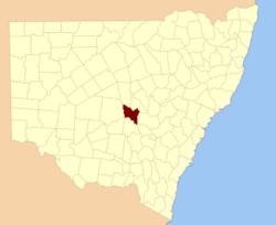
Cunningham County

Cunningham County
Cunningham
New South Wales
Cunningham NSW.PNG
Location in New South Wales
Lands administrative divisions around Cunningham
Flinders Kennedy Kennedy
Blaxland Cunningham Ashburnham
Dowling Gipps Forbes

Cunningham County is one of the 141 Cadastral divisions of New South Wales. It is located to the north of the Lachlan River near Condobolin.

Cunningham County was named in honour of the botanist and explorer Allan Cunningham (1791-1839).[1]

Parishes within this county

A full list of parishes found within this county; their current LGA and mapping coordinates to the approximate centre of each location is as follows:

Parish LGA Coordinates
Baratta Lachlan Shire Council 32°59′54″S 147°02′04″E / 32.99833°S 147.03444°E / -32.99833; 147.03444 (Baratta)
Bedgerebong Forbes Shire Council 33°18′54″S 147°40′04″E / 33.315°S 147.66778°E / -33.315; 147.66778 (Bedgerebong)
Berewombenia Forbes Shire Council 33°05′54″S 147°30′04″E / 33.09833°S 147.50111°E / -33.09833; 147.50111 (Berewombenia)
Bimbella Lachlan Shire Council 32°59′54″S 146°53′04″E / 32.99833°S 146.88444°E / -32.99833; 146.88444 (Bimbella)
Bomobbin Forbes Shire Council 33°10′54″S 147°20′04″E / 33.18167°S 147.33444°E / -33.18167; 147.33444 (Bomobbin)
Boona East Lachlan Shire Council 32°42′54″S 147°12′04″E / 32.715°S 147.20111°E / -32.715; 147.20111 (Boona East)
Boona West Lachlan Shire Council 32°39′54″S 147°05′04″E / 32.665°S 147.08444°E / -32.665; 147.08444 (Boona West)
Botfields Parkes Shire Council 33°00′54″S 147°45′04″E / 33.015°S 147.75111°E / -33.015; 147.75111 (Botfields)
Bundaburra Lachlan Shire Council 33°01′54″S 147°19′04″E / 33.03167°S 147.31778°E / -33.03167; 147.31778 (Bundaburra)
Burrawong Forbes Shire Council 33°13′54″S 147°31′04″E / 33.23167°S 147.51778°E / -33.23167; 147.51778 (Burrawong)
Byong Parkes Shire Council 33°00′54″S 147°35′04″E / 33.015°S 147.58444°E / -33.015; 147.58444 (Byong)
Carroboblin Parkes Shire Council 33°12′54″S 147°42′04″E / 33.215°S 147.70111°E / -33.215; 147.70111 (Carroboblin)
Condobolin Lachlan Shire Council 33°02′54″S 147°09′04″E / 33.04833°S 147.15111°E / -33.04833; 147.15111 (Condobolin)
Cookeys Plains Parkes Shire Council 33°04′54″S 147°39′04″E / 33.08167°S 147.65111°E / -33.08167; 147.65111 (Cookeys Plains)
Corella Lachlan Shire Council 32°41′54″S 147°18′04″E / 32.69833°S 147.30111°E / -32.69833; 147.30111 (Corella)
Corridgery Forbes Shire Council 33°18′54″S 147°46′04″E / 33.315°S 147.76778°E / -33.315; 147.76778 (Corridgery)
Derriwong Lachlan Shire Council 33°06′54″S 147°21′04″E / 33.115°S 147.35111°E / -33.115; 147.35111 (Derriwong)
Dulhunty Parkes Shire Council 33°09′54″S 147°47′04″E / 33.165°S 147.78444°E / -33.165; 147.78444 (Dulhunty)
Ellerslie Lachlan Shire Council 32°48′54″S 147°19′04″E / 32.815°S 147.31778°E / -32.815; 147.31778 (Ellerslie)
Elsmore Lachlan Shire Council 32°54′54″S 147°20′04″E / 32.915°S 147.33444°E / -32.915; 147.33444 (Elsmore)
Emu Plains Lachlan Shire Council 32°53′54″S 147°11′04″E / 32.89833°S 147.18444°E / -32.89833; 147.18444 (Emu Plains)
Gillenbine Lachlan Shire Council 32°48′54″S 147°34′04″E / 32.815°S 147.56778°E / -32.815; 147.56778 (Gillenbine)
Gindoono Lachlan Shire Council 32°36′25″S 146°54′37″E / 32.60694°S 146.91028°E / -32.60694; 146.91028 (Gindoono)
Goobang Forbes Shire Council 33°11′54″S 147°35′04″E / 33.19833°S 147.58444°E / -33.19833; 147.58444 (Goobang)
Greenock Lachlan Shire Council 32°49′09″S 146°53′31″E / 32.81917°S 146.89194°E / -32.81917; 146.89194 (Greenock)
Gulgo Lachlan Shire Council 33°02′54″S 147°03′04″E / 33.04833°S 147.05111°E / -33.04833; 147.05111 (Gulgo)
Gunning Parkes Shire Council 33°13′54″S 147°48′04″E / 33.23167°S 147.80111°E / -33.23167; 147.80111 (Gunning)
Gunningbland Parkes Shire Council 33°04′54″S 147°48′04″E / 33.08167°S 147.80111°E / -33.08167; 147.80111 (Gunningbland)
Jerula Lachlan Shire Council 32°49′29″S 147°10′33″E / 32.82472°S 147.17583°E / -32.82472; 147.17583 (Jerula)
Julandery Lachlan Shire Council 32°54′18″S 146°44′15″E / 32.905°S 146.7375°E / -32.905; 146.7375 (Julandery)
Kalinga Lachlan Shire Council 33°01′54″S 146°44′04″E / 33.03167°S 146.73444°E / -33.03167; 146.73444 (Kalinga)
Kars Parkes Shire Council 33°02′54″S 147°31′04″E / 33.04833°S 147.51778°E / -33.04833; 147.51778 (Kars)
Kiargathur Lachlan Shire Council 33°02′54″S 146°50′04″E / 33.04833°S 146.83444°E / -33.04833; 146.83444 (Kiargathur)
Mamre Lachlan Shire Council 32°42′12″S 146°41′45″E / 32.70333°S 146.69583°E / -32.70333; 146.69583 (Mamre)
Melrose Lachlan Shire Council 32°39′54″S 147°01′04″E / 32.665°S 147.01778°E / -32.665; 147.01778 (Melrose)
Micabil Lachlan Shire Council 33°03′54″S 147°00′04″E / 33.065°S 147.00111°E / -33.065; 147.00111 (Micabil)
Milpose Parkes Shire Council 33°00′54″S 147°51′04″E / 33.015°S 147.85111°E / -33.015; 147.85111 (Milpose)
Monomie Parkes Shire Council 33°07′54″S 147°42′04″E / 33.13167°S 147.70111°E / -33.13167; 147.70111 (Monomie)
Monwonga Forbes Shire Council 33°14′54″S 147°36′04″E / 33.24833°S 147.60111°E / -33.24833; 147.60111 (Monwonga)
Mount Nobby Lachlan Shire Council 32°45′24″S 146°55′15″E / 32.75667°S 146.92083°E / -32.75667; 146.92083 (Mount Nobby)
Mowabla Lachlan Shire Council 32°51′54″S 147°04′04″E / 32.865°S 147.06778°E / -32.865; 147.06778 (Mowabla)
Mulguthrie Forbes Shire Council 33°11′54″S 147°25′04″E / 33.19833°S 147.41778°E / -33.19833; 147.41778 (Mulguthrie)
Murda Lachlan Shire Council 33°00′54″S 147°08′04″E / 33.015°S 147.13444°E / -33.015; 147.13444 (Murda)
Murga Lachlan Shire Council 32°51′54″S 147°27′04″E / 32.865°S 147.45111°E / -32.865; 147.45111 (Murga)
Murrumbogie Lachlan Shire Council 32°59′54″S 147°26′04″E / 32.99833°S 147.43444°E / -32.99833; 147.43444 (Murrumbogie)
Oxley North Lachlan Shire Council 32°28′12″S 146°37′32″E / 32.47°S 146.62556°E / -32.47; 146.62556 (Oxley North)
Oxley South Lachlan Shire Council 32°33′28″S 146°39′45″E / 32.55778°S 146.6625°E / -32.55778; 146.6625 (Oxley South)
Palisthan Lachlan Shire Council 32°50′13″S 146°44′33″E / 32.83694°S 146.7425°E / -32.83694; 146.7425 (Palisthan)
Plevna Parkes Shire Council 32°52′54″S 147°44′04″E / 32.88167°S 147.73444°E / -32.88167; 147.73444 (Plevna)
Sebastopol Lachlan Shire Council 32°52′54″S 147°29′04″E / 32.88167°S 147.48444°E / -32.88167; 147.48444 (Sebastopol)
Taratta Lachlan Shire Council 32°43′54″S 147°04′04″E / 32.73167°S 147.06778°E / -32.73167; 147.06778 (Taratta)
Tinda Lachlan Shire Council 32°35′03″S 146°48′02″E / 32.58417°S 146.80056°E / -32.58417; 146.80056 (Tinda)
Tollingo Lachlan Shire Council 32°42′10″S 146°49′50″E / 32.70278°S 146.83056°E / -32.70278; 146.83056 (Tollingo)
Trundle Parkes Shire Council 32°56′54″S 147°44′04″E / 32.94833°S 147.73444°E / -32.94833; 147.73444 (Trundle)
Walker Lachlan Shire Council 32°29′40″S 146°44′07″E / 32.49444°S 146.73528°E / -32.49444; 146.73528 (Walker)
Wicklow Lachlan Shire Council 32°23′35″S 146°37′00″E / 32.39306°S 146.6166667°E / -32.39306; 146.6166667 (Wicklow)
Willama Lachlan Shire Council 32°38′54″S 146°41′32″E / 32.64833°S 146.69222°E / -32.64833; 146.69222 (Willama)
Wollongong Lachlan Shire Council 33°06′54″S 147°16′04″E / 33.115°S 147.26778°E / -33.115; 147.26778 (Wolongong)
Yarrabandai Forbes Shire Council 33°08′54″S 147°32′04″E / 33.14833°S 147.53444°E / -33.14833; 147.53444 (Yarrabandai)

References


Wikimedia Foundation. 2010.

Игры ⚽ Нужно сделать НИР?

Look at other dictionaries:

Share the article and excerpts

Direct link
Do a right-click on the link above
and select “Copy Link”