- Santa Lucia Range
-
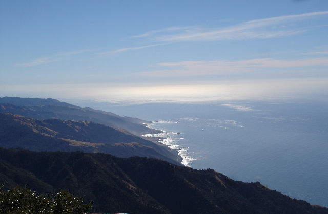
Santa Lucia Range Mountain Range 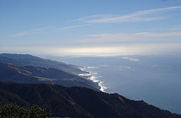 View from summit of Cone Peak, the highest coastal mountain in the lower 48 states
Country United States State California Region Monterey County
San Luis Obispo CountyCoordinates 36°3′3.861″N 121°28′8.769″W / 36.0510725°N 121.4691025°W Highest point - elevation 1,784 m (5,853 ft) Timezone Pacific (UTC-8) - summer (DST) PDT (UTC-7) Topo map USGS Cone Peak 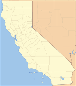
 location of Santa Lucia Range in California [1]
The Santa Lucia Mountains or Santa Lucia Range is a mountain range in coastal California, running from Monterey southeast for 105 miles (170 km) to San Luis Obispo. The highest summit is Junipero Serra Peak, 1,784 metres (5,853 ft)[2] in Monterey County. It is part of the Pacific Coast Ranges.
Contents
Toponymy
The first European to document the Santa Lucias was Juan Rodríguez Cabrillo in 1542 while sailing northward along the coast on a Spanish naval expedition. Cabrillo originally named the southern portion of the range the Sierras de San Martín, as he was passing the area on 11 November, the feast day for Saint Martin. He named the northern part Sierras Nevadas because there was snow on it.[3]
The present name for the range was documented in 1602 by Sebastián Vizcaíno, who had been tasked by the Spanish to complete a detailed chart of the coast. Passing by the range on 14 December, he named the range Sierra de Santa Lucia in honor of Saint Lucy of Syracuse.[3]
Climate
Like all other Pacific Coast Ranges, these mountains are close enough to the Pacific Ocean and high enough to force incoming moisture upward, making the west side wet and fit for conifers to grow. This creates a rain shadow over Salinas Valley to the east, which is considerably drier. The higher peaks receive some snowfall during the winter.
The climate is classified as Dry Summer Subtropical, or Mediterranean. Rainfall varies from 16 to 60 inches throughout the range, with the most on the higher mountains in the north; almost all precipitation falls in the winter. During the summer, fog and low clouds are frequent along the coast up to an elevation of several thousand feet. Surface runoff from rainfall events is rapid, and many streams dry up entirely in the summer, except for some perennial streams in the wetter areas in the north.[4]
Geology
The rock of the Santa Lucias is dominated by granitic basement of the Salinian Block, between the San Andreas Fault and Sur-Nacimiento Fault. According to plate tectonic theory, the core of the Salinian block formed as part of the same batholith which forms the core of the Sierra Nevada Mountains and the Peninsular Ranges of Baja California. It was broken off the North American Plate and transported north by the action of the San Andreas Fault from an original position. It is predominantly Mesozoic granitic and pre-Cretaceous metamorphic rocks. There is some Cretaceous sedimentary rock of the Great Valley Sequence, considerable Miocene marine sediments, and some other Tertiary sediments. Units west of the Sur-Nacimiento fault are dominated by rocks of the Franciscan Assemblage.
Flora
The west slope of the range facing the Pacific Ocean is moist with good forest growth including Coast Redwood, Douglas fir, Ponderosa Pine, Pacific Madrone and the local endemics Santa Lucia Fir (Abies bracteata) and Gowen Cypress (Cupressus goveniana var. goveniana), while the east side is drier, with chaparral and open woods of pine (including Coulter Pine and Gray Pine) and several species of oak. These mountains are home to the southernmost native stands of redwood trees, since the climate gets drier towards the south. This range is the only known habitat of the Vortriede's spineflower.
Major peaks
- Junipero Serra Peak, 1,784 metres (5,853 ft)[2]
- Cone Peak, 1,571 metres (5,154 ft).[5] Cone Peak features the steepest coastal elevation in the lower 48 United States, rising nearly a mile (1,609 m) above sea level, only three miles (5 km) from the Pacific Ocean.
- Ventana Double Cone, 1,477 metres (4,846 ft) [6]
- Mount Carmel, 1,344 metres (4,409 ft) [7]
Wine
The Santa Lucia Highlands AVA, a producer of California wine, is located in the region.
Transportation
California State Route 1 runs along the Big Sur coast to the west of the Santa Lucias, while U.S. Route 101 lies in the Salinas Valley to the East. The only road across the Santa Lucia Range is Nacimiento-Fergusson Road, from Lucia to Jolon.[8]
Contemporary History
Pacific Southwest Airlines Flight 1771 crashed in the mountains near Cayucos on December 7, 1987 after a gunman killed both pilots, causing the aircraft to crash. A total of 43 people were killed with no survivors.
References
- ^ "Santa Lucia Range". Geographic Names Information System, U.S. Geological Survey. http://geonames.usgs.gov/pls/gnispublic/f?p=gnispq:3:::NO::P3_FID:273555. Retrieved 2009-05-03.
- ^ a b "Junipero Serra Peak". Geographic Names Information System, U.S. Geological Survey. http://geonames.usgs.gov/pls/gnispublic/f?p=gnispq:3:::NO::P3_FID:271844. Retrieved 2009-05-03.
- ^ a b Gudde, Erwin G. (1949). California Place Names. Berkeley, California: University of California Press. p. 316. ASIN B000FMOPP4.
- ^ Santa Lucia Range ecological subregion information
- ^ "Cone Peak". Geographic Names Information System, U.S. Geological Survey. http://geonames.usgs.gov/pls/gnispublic/f?p=gnispq:3:::NO::P3_FID:270577. Retrieved 2009-05-03.
- ^ "Ventana Double Cone". Geographic Names Information System, U.S. Geological Survey. http://geonames.usgs.gov/pls/gnispublic/f?p=gnispq:3:::NO::P3_FID:255838. Retrieved 2009-05-03.
- ^ "Mount Carmel". Geographic Names Information System, U.S. Geological Survey. http://geonames.usgs.gov/pls/gnispublic/f?p=gnispq:3:::NO::P3_FID:270305. Retrieved 2009-05-03.
- ^ Bisbort, Alan; Puterbaugh, Parke (2009), Moon California Beaches: The Best Places to Swim, Play, Eat, and Stay (4th ed.), Avalon Travel, p. 305, ISBN 9781566916141; Schulte-Peevers, Andrea (2003), California (3rd ed.), Lonely Planet, p. 665, ISBN 9781864503319.
External links
- Ventana Wilderness Alliance — Dedicated to the protection, preservation, enhancement and restoration of the wilderness qualities and biodiversity of the public lands within California's northern Santa Lucia Mountains.
Categories:- California Coast Ranges
- Mountain ranges of Northern California
- Mountain ranges of Monterey County, California
- Mountain ranges of San Luis Obispo County, California
- Monterey Ranger District, Los Padres National Forest
- Los Padres National Forest

Wikimedia Foundation. 2010.