- Claife
-
Coordinates: 54°22′12″N 2°57′36″W / 54.370°N 2.960°W
Claife 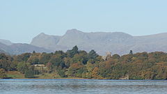
Wray Castle and the Langdale Pikes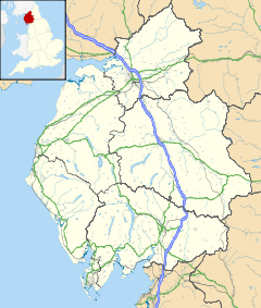
 Claife
Claife shown within CumbriaPopulation 392 (2001) OS grid reference SD3795 Parish Claife District South Lakeland Shire county Cumbria Region North West Country England Sovereign state United Kingdom Post town AMBLESIDE Postcode district LA22 Dialling code 01539 Police Cumbria Fire Cumbria Ambulance North West EU Parliament North West England UK Parliament Westmorland and Lonsdale List of places: UK • England • Cumbria Claife is a civil parish in the South Lakeland district of Cumbria, England. It is situated west of Windermere, and east of Esthwaite Water and the village of Hawkshead. In the 2001 census the parish had a population of 392.[1] Settlements in the parish include two villages, Near and Far Sawrey in the south; and the hamlets of High Wray, Low Wray, Colthouse and Loanthwaite in the north.
In the central area of the parish is Claife Heights, a hilly area which rises to 800 feet (240 m) above sea level at Latterbarrow and contains several tarns.[2] There is one major road in the parish, the B5285 connecting Hawkshead to the Windermere Ferry terminus at Far Sawrey.
At Low Wray is Wray Castle, a 19th century house and grounds now owned by the National Trust. Many of the woodlands in the parish, including the area alongside Windermere are part of the National Trust's Hawkshead and Claife property.[3]
References
- ^ "Parish information from the 2001 census". Cumbria County Council. http://www.cumbria.gov.uk/eLibrary/Content/Internet/536/642/1369/3936414473.pdf. Retrieved 2009-02-14.
- ^ "'Townships: Claife', A History of the County of Lancaster: Volume 8 (1914)". University of London & History of Parliament Trust. p. 380. http://www.british-history.ac.uk/report.aspx?compid=53337. Retrieved 2009-02-14.
- ^ "Hawkshead and Claife". National Trust. http://www.nationaltrust.org.uk/main/w-vh/w-visits/w-findaplace/w-hawksheadandclaife/. Retrieved 2009-02-14.
Ceremonial county of Cumbria Boroughs or districts Major settlements - Alston
- Ambleside
- Appleby-in-Westmorland
- Aspatria
- Barrow-in-Furness
- Bowness-on-Windermere
- Brampton
- Broughton-in-Furness
- Carlisle
- Cleator Moor
- Cockermouth
- Dalton-in-Furness
- Egremont
- Grange-over-Sands
- Harrington
- Kendal
- Keswick
- Kirkby Lonsdale
- Kirkby Stephen
- Longtown
- Maryport
- Millom
- Penrith
- Sedbergh
- Silloth
- Ulverston
- Whitehaven
- Wigton
- Windermere
- Workington
See also: List of civil parishes in Cumbria
Topics Categories:- Cumbria geography stubs
- Civil parishes in Cumbria


Wikimedia Foundation. 2010.