- City, Australian Capital Territory
-
City
Canberra, Australian Capital Territory
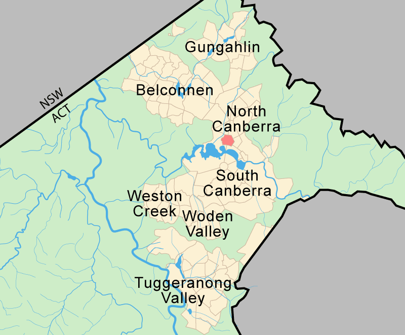
Population: 723 (2006 census)[1] Established: 1928 Postcode: 2601 District: North Canberra Assembly Electorate: Molonglo Federal Division: Fraser Suburbs around City: Turner Braddon Acton City Reid Lake Burley Griffin Parkes The central business district of Canberra, Australia's capital city, is officially named City (postcode: 2601).[2] However it is also referred to as Civic, Civic Centre, City Centre, Canberra City and Canberra (postcode: 2600).
Canberra's City was officially established in 1927, although the suburb name City was not gazetted until 20 September 1928. Walter Burley Griffin's design for Canberra included a "Civic Centre" with a separate "Market Centre" located at what is now Russell. However Prime Minister Stanley Bruce vetoed this idea and only the Civic Centre was developed; the idea of the "Market Centre" was abandoned.
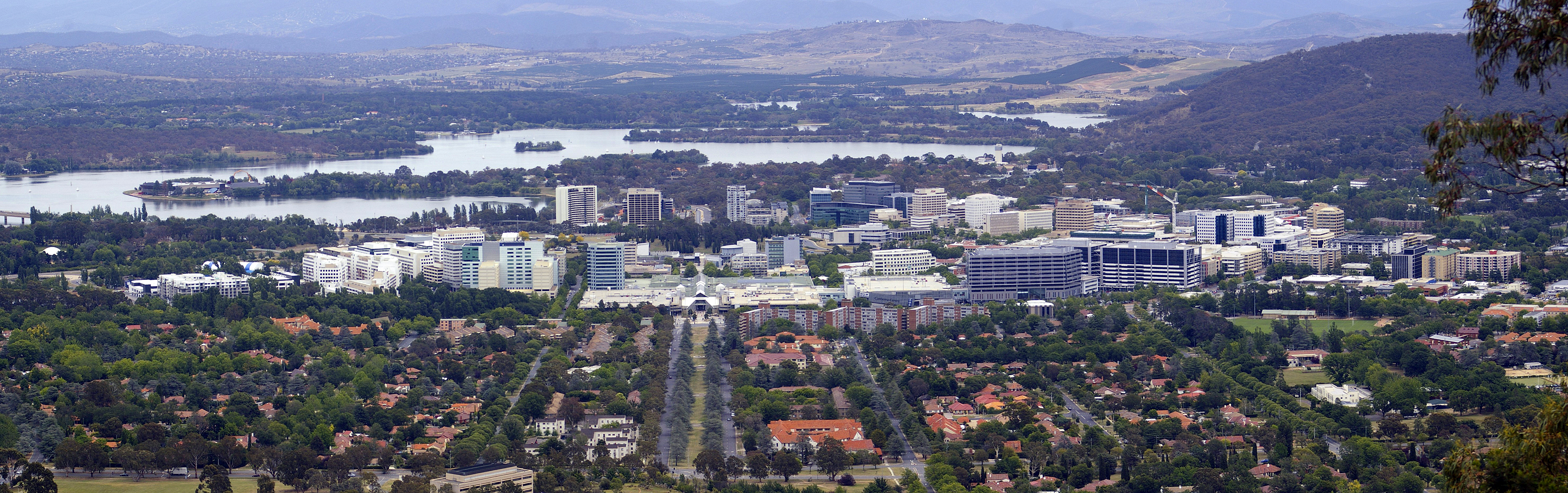
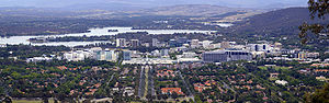 Canberra City viewed from Mount Ainslie with Lake Burley Griffin and Mount Stromlo in the background.
Contents
Overview
Some of the earliest buildings constructed in Canberra were the Sydney and Melbourne buildings which flank Northbourne Avenue. The buildings house many shops, bars and restaurants, including Mooseheads on London Circuit, which is the longest established bar and night club in Civic, having opened in 1990. Fletcher Jones, an Australian clothing brand, has operated its Canberra store in the Sydney building since 1962.
The Canberra Centre, a three-storey shopping complex is Civic's main shopping precinct with a retail presence from the national chains David Jones, Myer, Big W and Target department stores. Nearby is Glebe Park, a picturesque park near the centre of the city with elm trees and oaks from early European settlement before the city was founded. Civic also is home to the Canberra Theatre, Casino Canberra, Canberra Museum and Gallery and the National Convention Centre.
Garema Place and City Walk are open areas of Civic for pedestrian traffic with many outdoor cafes. One of the longest running cafes in Civic is Gus's Cafe on Bunda Street.
A local bus interchange predominantly used by ACTION, the ACT government-operated bus service, is located on East Row, Alinga Street, Mort Street and Northbourne Avenue. On the western side of Northbourne Avenue (north of Alinga Street) is the Jolimont Centre, which is the bus terminal for Greyhound Australia and Murrays.
Unlike many cities, Canberra has very strict planning rules including height limits on buildings: the maximum height of the office tower blocks in Civic is 13 floors, giving Canberra a "small town feel" to many visitors.
History
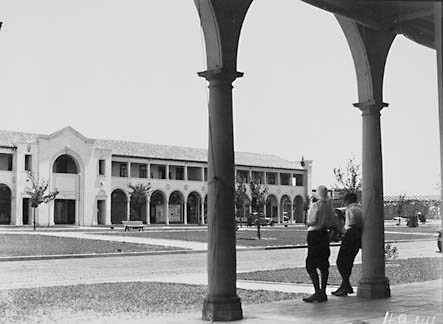
 1929 picture of the Sydney Building looking across Northbourne Avenue from the Melbourne Building
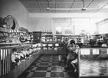 Blue Moon Cafe in 1953
Before the development of the City of Canberra, there was no clear commercial centre for the area, other than nearby Queanbeyan. Murray's store, considered the area's first retail store, operated from a house built in 1874 on the glebe of St John the Baptist Church, within the present boundaries of Commonwealth Park, to the east of what is now Nerang Pool. It burnt down in 1923.
Griffin's plan separated the national centre, the administrative centre of the city, now the Parliamentary Triangle, from the Civic Centre, the principal commercial area. The commercial centre was planned to be on what Griffin described as the Municipal Axis which was projected to run north-west from Mount Pleasant. Variations from Griffin's plan that affect City include the abandonment of a city railway and a reduction in the widths of some streets, including of London Circuit which was planned to be 200 feet (61 m) and was reduced to 100 feet (30 m). Griffin's civic focus on Vernon Knoll, now known as City Hill, has not materialised mainly because of the way city building has progressed.[3]
The first major buildings planned for the commercial centre were the Melbourne and Sydney Buildings. Construction began in 1926 [4] and they were finally completed in 1946. Immediately after World War II, the Melbourne and Sydney buildings still comprised the main part of Civic and the Blue Moon Cafe was the only place to go for a meal apart from the Hotel Canberra and the Hotel Civic.[5]
Up until the 1960s, Canberra shoppers found the retail environment frustrating. Many did their weekly shopping in Queanbeyan, where the central business district was more compact.[3] Major purchases were made in Sydney.[5] In 1963, the Monaro Mall (now Canberra Centre) opened. It included a branch of the David Jones department store.
Notable buildings and urban spaces
Sydney and Melbourne Buildings
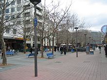 City Walk, a pedestrian mall in Civic is a focus of retail activity and outdoor dining.
The Melbourne and Sydney buildings were based on design principles set by John Sulman in sketch form. The design work was finalised by J H Kirkpatrick. The buildings were the model which establish the colonnade principle, an important design element throughout Civic.[6] From 1921 to 1924 Sulman was chairman of the Federal Capital Advisory Committee, and in that role was involved in the planning of Canberra and refining Griffin's plan.
Sulman's concept of arcaded loggias was derived from Brunelleschi's Ospedale degli Innocenti (Foundling Hospital) and the cloisters of the 15th century Basilica di San Lorenzo di Firenze. The Mediterranean influence was maintained by Kirkpatrick with Roman roof tiles and cast embellishments such as roundels. The buildings were originally constructed with open first floor verandahs which have since largely been glazed in.
The Melbourne Building was sold sequentially as independent parcels from 1927 until 1946. The corner of West Row and London Circuit was built specifically for the Bank of New South Wales (now the Westpac Banking Corporation). The manager lived above the bank. Much of the Melbourne Building facing West Row was completed by the Commonwealth Government in 1946 and used as the location of the Commonwealth Employment Service. From 1944 to 1953, the Canberra University College was housed in the Melbourne building. On 11 April 1953 the Melbourne Building was severely damaged by fire and the college relocated (it eventually became the Australian National University).
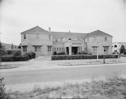
Hotel Civic
 Hotel Civic Canberra
The Hotel Civic opened in 1935. It was constructed in an Art Deco style from Canberra Cream bricks. It was demolished in late 1984 through early 1985.[7] The hotel was on the corner of Alinga Street and the eastern side of Northbourne Avenue.
In 1965, the Hotel Civic was the scene of a protest about the segregation of women in the hotel:
... a protest where a number of us [including the interviewee Helen Jarvis] chained ourselves to the bar in the Hotel Civic. Women weren't allowed to be served in the public bar -- that was the law in both NSW and the ACT. We had to use the saloon bar or the ladies' bar, where prices were higher, or to huddle out the back around the old kegs. They were also morose places, at least at the Civic, which was the only pub near the university. The public bar had all the spirit. We chained ourselves to the public bar. The bartender wouldn't serve us, but there were some sympathetic men who bought drinks for us. The newspapers trivialised it, of course: they wrote it up with the headline, “Women breast the bar”.[8]
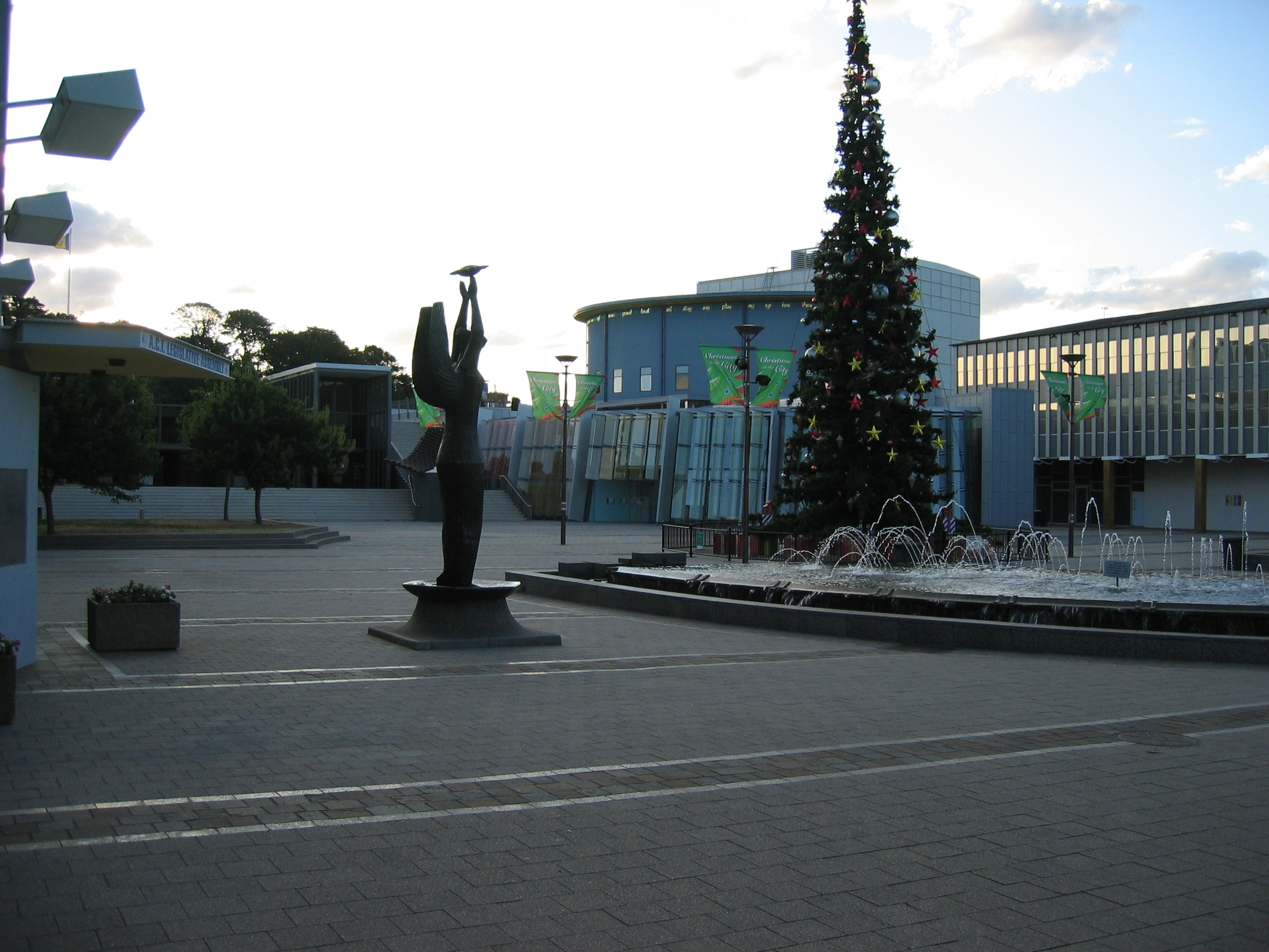
Civic Square
 Civic Square
Civic Square houses the Australian Capital Territory Legislative Assembly, Canberra Museum and Gallery, Civic Library and Canberra Theatre as well as many local cultural organisations, including the Canberra division of the National Trust of Australia.
Civic Square was designed by Yuncken Freeman architects and completed in 1961.[citation needed] Civic Square is sited within a primary axis of Griffin's design for Canberra which links City Hill and Mount Ainslie. Griffin intended that the square be the ‘heart of the city’. Civic Square is listed on the register of the National Estate.[citation needed]
The Canberra Theatre was opened in June 1965 with the Australian Ballet’s production of Swan Lake. The old Playhouse, also from 1965, was demolished and rebuilt in 1998. The link between the Theatre and Playhouse buildings has been redeveloped to include the Civic Library and the theatre's bar and administration area.
A sculpture of Ethos by Tom Bass was commissioned by the National Capital Development Commission in 1959 and unveiled in 1961. "The NCDC intended that the work would emphasize that Canberra is the non-political centre, the locale of commerce and of private enterprise in its best sense." The sculpture was designed to represent the spirit of the community. Bass interpreted this in the figure which he intended "the love which Canberra people have for their city to be identified with her...I want them to be conscious of her first as an image from a distance...then comes the moment when they become personally involved with her... they feel her looking at them, reflecting their love for the place".
The form of the work is highly symbolic. The figure is robed in a fabric richly embossed with emblems and figures representing the Community. The shallow saucer on which the figure stands represents Canberra's nick-name "Frosty Hollow". The saucer is 6 sided because the plan for Civic square is itself hexagonal. The surface of the saucer bears a relief map of Canberra and the rolling countryside around it. At the feet of Ethos are indentations that represent the lake that was later to fill the space between the Civic Centre and the administrative part of the city. The bursting sun she holds aloft is symbolic of culture and enlightenment which the presence of Canberra's University, its research organisations and the Diplomatic Corps and so on give to the city.
Bass regarded the work as his most important civic work. During the 1960s and 70s, pictures of the sculpture were frequently used in Canberra tourism images.[9]
Canberra Centre
Main article: Canberra CentreCivic's major shopping mall is the Canberra Centre. Opened as the Monaro Mall in 1963, it was the first Australian three-storey, fully enclosed and air conditioned shopping centre. It was opened by the Prime Minister Robert Menzies. In 1989 it was substantially redeveloped and renamed the Canberra Centre. A further redevelopment was completed by late 2007, substantially adding to the diversity of retailers and services within it including a Dendy Cinema complex.
See also
References
- ^ Australian Bureau of Statistics (25 October 2007). "City (State Suburb)". 2006 Census QuickStats. http://www.censusdata.abs.gov.au/ABSNavigation/prenav/LocationSearch?collection=Census&period=2006&areacode=SSC81091&producttype=QuickStats&breadcrumb=PL&action=401. Retrieved 2009-01-18.
- ^ "Suburb Name search results". ACT Planning & Land Authority. http://apps.actpla.act.gov.au/actlic/places/search/suburbResults_new3.asp?suburbName=CITY&Submit=Continue. Retrieved 16 January 2009.[dead link]
- ^ a b King, H.W. (1954). "Factors of Site and Plan". In Edited by H.L. White. Canberra: A Nation's Capital. Angus and Robertson, Sydney. pp. 209–220.
- ^ "Building of Civic Centre". The Canberra Times. 1926-09-10. http://ndpbeta.nla.gov.au/ndp/del/article/1206913. Retrieved 2008-08-24.
- ^ a b Green, Stephanie. "Gorman House history". Gorman House Arts Centre. http://www.gormanhouse.com.au/info/history.php. Retrieved 2006-05-16.
- ^ "20032. Melbourne and Sydney Buildings" (pdf). Entry to the ACT Heritage Register; Heritage Act 2004. ACT Heritage Council. Archived from the original on 2006-08-19. http://web.archive.org/web/20060819233335/http://www.environment.act.gov.au/__data/assets/pdf_file/12980/heritageregister20032.pdf. Retrieved 2006-05-16.
- ^ "60 tonne capacity excavator demolishes the Hotel Civic; photograph taken 30 January 1985". Image Library. ACT Heritage Library. http://www.basis.act.gov.au/DUSLibrary/ImagesACT.nsf/3506a89b45287c52ca256abc000c49a8/3619baae734d515c4a256bcd001d76b4!OpenDocument. Retrieved 2006-05-16.
- ^ Cheng, Eva. "Vietnam and the women's liberation movement". Green Left Weekly. http://www.greenleft.org.au/back/1995/184/184p11.htm. Retrieved 2006-05-16.
- ^ "10007. Ethos statue" (pdf). Entry to the ACT Heritage Register; Heritage Act 2004. ACT Heritage Council. Archived from the original on 2006-08-20. http://web.archive.org/web/20060820005919/http://www.environment.act.gov.au/__data/assets/pdf_file/13669/heritageregister10007.pdf. Retrieved 2006-05-16.
External links
Coordinates: 35°16′55″S 149°07′43″E / 35.282°S 149.1286°E
Districts in Canberra: Belconnen · Gungahlin · Molonglo Valley · North Canberra · South Canberra · Tuggeranong · Weston Creek · Woden Valley
see also: Suburbs of Canberra · List of Canberra suburbsCategories:- Suburbs of Canberra
- Central business districts in Australia


Wikimedia Foundation. 2010.