- St Mungo's Church, Bromfield
-
St Mungo's Church, Bromfield 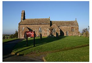
St Mungo's Church, Bromfield, from the southLocation in Cumbria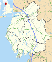
 St Mungo's Church, Bromfield
Coordinates: 54°48′41″N 3°17′02″W / 54.8114°N 3.2840°W OS grid reference NY 175 470 Location Bromfield, Cumbria Country England Denomination Anglican History Dedication Saint Mungo Architecture Status Parish church Functional status Active Heritage designation Grade I Designated 11 April 1967 Architectural type Church Style Norman, Gothic Specifications Materials Sandstone rubble
Sandstone slate roofAdministration Parish Bromfield Deanery Solway Archdeaconry West Cumberland Diocese Carlisle Province York Clergy Vicar(s) Revd David Tembey St Mungo's Church, Bromfield, is in the village of Bromfield, Cumbria, England. It is an active Anglican parish church in the deanery of Solway, the archdeaconry of West Cumberland and the diocese of Carlisle.[1] The church has been designated by English Heritage as a Grade I listed building.[2]
Contents
History
The church dates from the 12th century with additions and alterations during the next two centuries. Restorations were carried out in 1861–62, 1893–94 and 1926.[2]
Architecture
Exterior
St Mungo's is constructed in red sandstone rubble with a sandstone slate roof. It has coped gables on which are cross finials. The plan consists of a two-bay nave with a north aisle, a south porch and a north vestry, and a two-bay chancel with side chapels and a lean-to hearse house. On the west gable is a twin bellcote and on the east gable is another bellcote for the angelus bell. In the porch is a re-set Norman doorway with zigzag carving.[2] On the east wall of the nave on each side of the chancel arch are stretches of a Norman frieze decorated with saltaire crosses. The church originally had transepts, but due to extensions of the church, they now lie east of the chancel arch, the north transept having been absorbed in the aisle.[3] The south chapel was originally a chantry, then walled off from the chancel, has been made into a memorial to the victims of the First World War, and is known as St George's chapel. The south chapel is the Crookdake Chapel and contains a graveslab to Adam Crookdake who died in 1304.[2]
Interior
The font dates from the 12th century and is set on a hexagonal stem. In the south wall is a piscina and there are aumbries on each side of the altar. The pews, communion rail and altar screen date from the 19th century. The church contains an 18th-century Royal coat of arms, and on the walls are memorial plaques from the 18th and 19th centuries. Inside the porch are fragments of a medieval cross and graveslabs.[2]
External features
To the north of the church is a holy well also dedicated to St Mungo.[3] Over it is a circular sandstone wellhead with a conical stone cap dating from 1878; it is listed Grade II.[4]
See also
- Grade I listed buildings in Cumbria
References
- ^ Bromfield, St Mungo, Church of England, http://www.achurchnearyou.com/bromfield-st-mungo/, retrieved 24 March 2010
- ^ a b c d e "Church of St Mungo, Bromfield", The National Heritage List for England (English Heritage), 2011, http://list.english-heritage.org.uk/resultsingle.aspx?uid=1235049, retrieved 12 May 2011
- ^ a b Pevsner, Nikolaus (2002) [1967], Cumberland and Westmorland, The Buildings of England, New Haven and London: Yale University Press, pp. 79–80, ISBN 0-300-09590-2
- ^ "St Mungo's Well, Bromfield", The National Heritage List for England (English Heritage), 2011, http://list.english-heritage.org.uk/resultsingle.aspx?uid=1276083, retrieved 12 May 2011
External links
Categories:- Church of England churches in Cumbria
- Grade I listed churches
- Grade I listed buildings in Cumbria
- Norman architecture
- English Gothic architecture
- Holy wells
- Diocese of Carlisle


Wikimedia Foundation. 2010.