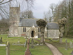
- Church of St. Andrew, Holcombe
-
Church of St. Andrew Location: Holcombe, Somerset, England Coordinates: 51°15′17″N 2°28′33″W / 51.25472°N 2.47583°WCoordinates: 51°15′17″N 2°28′33″W / 51.25472°N 2.47583°W Built: 16th century Governing body: Churches Conservation Trust Listed Building – Grade II* Official name: Church of St. Andrew Designated: 2 June 1961[1] Reference #: 267901 The Church of St. Andrew close to Downside Abbey in Holcombe, Somerset, England has late Saxon-early Norman origins and was rebuilt in the 16th century. It has been designated by English Heritage as a Grade II* listed building,[1] and is now a redundant church in the care of the Churches Conservation Trust.[2] It was vested in the Trust on 1 August 1987.[3]
The church has a two stage tower and two bay nave.[1]
The interior includes late Georgian box pews[2] and a Jacobean pulpit.[1] In the graveyard is a memorial to the family of Robert Falcon Scott whose father managed the brewery in the village. There is also a yew tree that is thought to be about 1500 years old.[4]
The original medieval village was buried at the time of the plague and St Andrews is surrounded by the mounds that bear testimony to this burial. It is suggested that the rhyme 'Ring a Ring o' Roses' began there as a result. An alternative explanation relates to the drowning of five children from the village in an icy pond in 1899.[5]
The parish is part of the benefice of Coleford with Holcombe within the Midsomer Norton deanery.[6]
See also
- List of churches preserved by the Churches Conservation Trust in South West England
References
- ^ a b c d "Church of St Andrew". Images of England. http://www.imagesofengland.org.uk/details/default.aspx?id=267901. Retrieved 20 November 2007.
- ^ a b St Andrew's Church, Holcombe, Somerset, Churches Conservation Trust, http://www.visitchurches.org.uk/Ourchurches/Completelistofchurches/St-Andrews-Church-Holcombe-Somerset/, retrieved 2 April 2011
- ^ (PDF) Diocese of Bath and Wells: All Schemes, Church Commissioners/Statistics, Church of England, 2011, p. 3, http://www.churchofengland.org/media/810289/bath%20and%20wells%20-%20all%20schemes.pdf, retrieved 2 April 2011
- ^ "Holcombe village design statement". Mendip Council. http://www.mendip.gov.uk/Documents/Holcombe%20Village%20Design%20Statement.pdf. Retrieved 1 October 2011.
- ^ "St Andrews Old Church Holcombe Somerset". Imaging me. http://www.imaging.me.uk/church_page.htm. Retrieved 23 October 2010.
- ^ "St Andrew, Holcombe". Church of England. http://www.achurchnearyou.com/holcombe-st-andrew/. Retrieved 1 October 2011.
Categories:- Church of England churches in Somerset
- Grade II* listed churches
- Grade II* listed buildings in Somerset
- Churches preserved by the Churches Conservation Trust
Wikimedia Foundation. 2010.


