- Church Farmhouse Museum
-
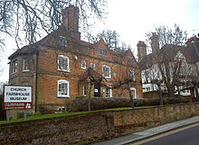 Church Farmhouse Museum from Greyhound Hill
Church Farmhouse Museum is a Grade II* listed 17th century farmhouse in Hendon, in the London Borough of Barnet. The building is the oldest surviving dwelling in Hendon.[1]
The museum has two period rooms, a period kitchen and scullery, two exhibition spaces and a large garden with pond. The building is a two-storey, red brick farmhouse with three gables and centrally placed chimney stacks.[2] It is typical of 17th-century Middlesex vernacular architecture.[3]
Barnet Council, in an attempt to save a very small amount of money and despite considerable local opposition, voted to withdraw funding from Church Farmhouse Museum, as well as Barnet Museum, from April 2011. The Council’s cabinet met on Monday 13 December 2010 and approved the budget for 2010/2011 which included this proposal. There was a brief period of public consultation up to 17 January 2011, followed by a final recommendation by the Cabinet in February, as a result of which the museum closed, for the time being, on 31 March 2011. The final temporary exhibition, "Harry Beck and the London Tube Map", closed on 27 March 2011. The building's future remains uncertain.
References
- ^ "350 Years of Church Farm". Committee of the Friends of Church Farmhouse Museum. http://www.churchfarmhousemuseum.co.uk/News.htm. Retrieved 6 November 2010.
- ^ Pevsner, Nikolaus; Bridget Cherry (1999). London 4: North. Penguin Books. pp. 163–4. ISBN 0140710493.
- ^ Baker, T F T. "Hendon: Growth before 1850". Brtish History Online. http://www.british-history.ac.uk/report.aspx?compid=26879. Retrieved 6 November 2010.
External links
Museums of London history Regional Borough Valence House (Barking and Dagenham) · Barnet · Hall Place (Bexley) · Brent · Bromley · Camden · Croydon · Forty Hall (Enfield) · Greenwich · Hackney · Bruce Castle (Haringey) · Harrow · Havering · Gunnersbury Park (Hounslow) · Islington · Kingston upon Thames · Newham · Redbridge · Richmond · Cuming (Southwark) · Vestry House (Waltham Forest) · Wandsworth
Categories:- Museums established in 1954
- Museums in Barnet
- Local museums in London
- Historic house museums in London
- Museum stubs


Wikimedia Foundation. 2010.