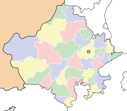
- Chohtan
-
Chohtan — village — Coordinates 25°28′59″N 71°04′0″E / 25.48306°N 71.066667°ECoordinates: 25°28′59″N 71°04′0″E / 25.48306°N 71.066667°E Country India State Rajasthan District(s) Barmer Nearest city Bajrang Pura Dharasar Parliamentary constituency Barmer Literacy 50%% Time zone IST (UTC+05:30) Area
• 178 metres (584 ft)
Chohtan is a village in Barmer district of Rajasthan state. It is a tehsil headquarter.
There are several temples in the area, including Viratra, Deri Dungar, and Sunya mata ka mandir.
Geography
Chohtan is surrounded by hills in east and north and by desert to the west and south. The village is located approximately 50 km from Barmer. It is connected via a road to Barmer. The village got the importance because of Pakistan border.
Theew are regular bus services from Chohtan to Barmer and Ahmedabad. It is very near from Pakistan.It is 30 KM approx from Pakistan. In history when fight was running then all villagers go to desert and keep a light then Pakistan's pilots was confused and they throw down the missiles but no casualty happened.
Demographics
According to the Indian Census 2001, the population of Chotan is 12,148, where male constituts 6,622 and female constitutes 5,526.[1]
References
Barmer Cities and towns
in other districtsAjmer · Alwar · Banswara · Baran · Bharatpur · Bhilwara · Bikaner · Bundi · Chittorgarh · Churu · Dausa · Dholpur · Dungarpur · Hanumangarh · Jaipur · Jaisalmer · Jalore · Jhalawar · Jhunjhunu · Jodhpur · Karauli · Kota · Nagaur · Pali · Pratapgarh · Rajsamand · Sawai Madhopur · Sikar · Sirohi · Sri Ganganagar · Tonk · Udaipur
Categories:- Villages in Barmer district
- Barmer district
- Rajasthan geography stubs
Wikimedia Foundation. 2010.


