- Chard Reservoir
-
Chard Reservoir 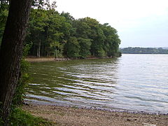
Location Chard, Somerset, England Coordinates 50°53′04″N 2°56′34″W / 50.88444°N 2.94278°WCoordinates: 50°53′04″N 2°56′34″W / 50.88444°N 2.94278°W Primary inflows River Isle Primary outflows river Isle Catchment area 7.65 km2[1] Built 1842 Surface area 36.97 hectares (91.4 acres) Water volume 795,000 m3[1] Chard Reservoir is a 36.97 hectares (91.4 acres) reservoir north east of Chard Somerset, England. It is owned and managed by South Somerset District Council[2] and is a recipient of the Green Flag Award.[3]
It was built on the river Isle in 1842 to provide water for the Chard Canal.[2]
It is a Local Nature Reserve. It is used for dog walking, fishing and birdwatching, with a bird hide having been installed.[4] Bird species which are spotted regularly include Herons, Kingfishers, Cormorants, Grebes, ducks and also a wide range of woodland songbirds. Others include the Great white egret, Cattle egret, and Spotted redshank.
The water is stocked with carp.[3]
References
- ^ a b "Chard reservoir management plan". South Somerset Council. p. 11. http://www.southsomerset.gov.uk/media/41558/chard_reservoir_management_plan_2009-2013.pdf. Retrieved 18 November 2010.
- ^ a b "Chard Reservoir leaflet". south Somerset Council. http://www.southsomerset.gov.uk/media/41561/chard_reservoir_leaflet.pdf. Retrieved 18 November 2010.
- ^ a b "Chard Reservoir Local Nature Reserve". Green Flag Award. Kepp Britain Tidy. http://www.keepbritaintidy.org/GreenFlag/GreenFlagAwardSites/SouthWest/Default.aspx?parkID=949. Retrieved 18 November 2010.
- ^ "Chard Reservoir Nature Reserve". Chard Reservoir Nature Reserve. http://www.chardres.totalserve.co.uk/. Retrieved 18 November 2010.
Categories:- Geography of Somerset
- Local Nature Reserves in England
- Chard, Somerset
- Nature reserves in Somerset

Wikimedia Foundation. 2010.