- Chandlerville, Kentucky
-
Chandlerville — Unincorporated community — Location within the state of Kentucky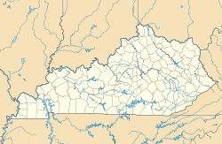
 Chandlerville
Coordinates: 37°56′05″N 82°48′49″W / 37.93472°N 82.81361°WCoordinates: 37°56′05″N 82°48′49″W / 37.93472°N 82.81361°W Country United States State Kentucky County Johnson Elevation 860 ft (262 m) Time zone Eastern (EST) (UTC-5) – Summer (DST) EDT (UTC-4) ZIP codes 41257 FIPS code GNIS feature ID 507684 Chandlerville is an unincorporated community in Johnson County, Kentucky, United States. It is at an elevation of 860 feet (262 m).[1] Chandlerville's ZIP code is 41257.
References
- ^ U.S. Geological Survey Geographic Names Information System: Chandlerville, Kentucky Retrieved on 2009-11-28
Municipalities and communities of Johnson County, Kentucky City 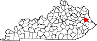
Unincorporated
communitiesAsa | Boonscamp | Chandlerville | Collista | Denver | Dobson | East Point | Elna | Flat Gap | Fuget | Hager Hill | Hargis | Keaton | Kerz | Leander | Low Gap | Manila | Meally | Nero | Nippa | Odds | Offutt | Oil Springs | Redbush | Riceville | River | Sip | Sitka | Staffordsville | Stambaugh | Swamp Branch | Thealka | Thelma | Tutor Key | Van Lear | Volga | West Van Lear | Whitehouse | Williamsport | Winifred | Wittensville
Categories:- Populated places in Johnson County, Kentucky
- Unincorporated communities in Kentucky


Wikimedia Foundation. 2010.