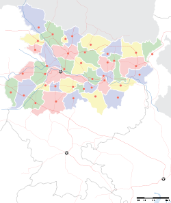
Chainpur, Bihar

Chainpur, Bihar
Chainpur
—  city  —
Chainpur
Location of Chainpur
in Bihar and India
Coordinates 25°31′N 86°19′E / 25.52°N 86.31°E / 25.52; 86.31Coordinates: 25°31′N 86°19′E / 25.52°N 86.31°E / 25.52; 86.31
Country India
State Bihar
District(s) Saharsa
Population 25,584 (2001)
Official languages Hindi, Maithali, English
Time zone IST (UTC+05:30)
Area

Elevation


41 metres (135 ft)

Chainpur one of the largest villages of Saharsa district in the Indian state of Bihar in North-East India, and is in the Kosi Division. Chainpur has a number of tolas and occasionally called Pubari, Pachhwari, Uttarwari and Dakshinwari tola.

The origin of the name Chainpur is not known but it is said that when Shri Bhagirath Thakur (one of the earliest inhabitant of this village) came to this place, it was quiet peaceful (that is, "chain" in Hindi language), hence the village got its name of Chainpur.

Chainpur is part of Kahra Block. Chainpur is located in among Bariahi, Bangaon, Parari and Mahishi.

Chainpur and its surrounding areas are a flat alluvial plain forming part of the Kosi river basin. This makes the land very fertile.

Flooding is a major reason for the poor connectivity of the area as bridges tend to get washed away.

References

  • Chainpur, Mithila ka Gaurav by Shri Shri Kant jha

External links


Wikimedia Foundation. 2010.

Игры ⚽ Нужна курсовая?

Look at other dictionaries:

  • Chainpur — may refer to several places: Chainpur, Bagmati, Nepal Chainpur, Kosi, Nepal Chainpur, Narayani, Nepal Chainpur, Seti, Nepal Chainpur, Bihar, India Chainpur block, Gumla, Jharkhand, India Chainpur block, Palamu, Jharkhand, India …   Wikipedia

  • Chainpur, India — Chainpur is a market town, situated 11 Km west of Bhabua, headquarters of the Kaimur district of Bihar. HistoryThe Raja Zamindar of Gaya, Bihar: History of the Raman family of Banaras since 1540 ADZamindari Name: Gaya Kothi Benaras Kothi. Second… …   Wikipedia

  • Moke Village, Bihar —   town   …   Wikipedia

  • Sikarwar — Rajputs is an old clan of Suryavansha Dynasty Rajputs from the first century A.D. They draw their name from Sikar (Rajasthan), the district that was allocated to Swarup Rao Sikarwar to rule. Later Keshevdev Sikarwar founded the city of Sikri… …   Wikipedia

  • Chhapra —   city   …   Wikipedia

  • Meteorite fall — Witnessed Bolide Meteorite falls, also called observed falls, are those meteorites that were witnessed by people or automated devices as they moved through the atmosphere or hit the Earth, and were subsequently collected. All other meteorites are …   Wikipedia

  • History of Limbuwan — The History of Limbuwan ( Nepali: लिम्बुवानको ईतिहास ) is characterised by the close interaction of Limbuwan with its neighbours; independent and semi independent rule characterized by autonomy for most of its time. From the time of King… …   Wikipedia

  • Kaimur district — Kaimur is an administrative district in the state of Bihar in India. The district headquarters are located at Bhabua. The district occupies an area of 3363 km² and has a population of 12,84,575(as of 2001).A considerable hilly, forested area,… …   Wikipedia

  • Saharsa district — Saharsa is one of one of the thirty seven districts of Bihar, India. Saharsa town is the administrative headquarters of this district.Saharsa district is a part of a larger territory, the Kosi Division and it became a district on 1 April 1954 and …   Wikipedia

  • Albert Ekka — Lance Naik (LCpl) Albert Ekka (1942 71) was a soldier in the Indian army. He died in service in the Battle of Hilli, during the Bangladesh Liberation War of 1971. He was posthumously awarded the Param Vir Chakra, India s highest award for valour… …   Wikipedia

Share the article and excerpts

Direct link
Do a right-click on the link above
and select “Copy Link”