- Maruyama Dam
-
Maruyama Dam 
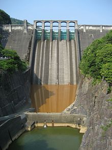
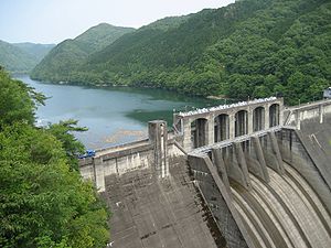
Location Mitake, Gifu Prefecture, Japan. Coordinates 35°28′08.0″N 137°10′20.0″E / 35.46889°N 137.17222°ECoordinates: 35°28′08.0″N 137°10′20.0″E / 35.46889°N 137.17222°E Construction began 1943 Opening date 1955 Owner(s) MLIT and Kansai Electric Power Company Dam and spillways Height 98.2 m Length 260 m Impounds Kiso River Reservoir Capacity 79,520,000 m³ Catchment area 2,409.0 km² Surface area 263 hectares The Maruyama Dam (丸山ダム Maruyama Damu) is a dam on the border of Mitake and Yaotsu in Gifu Prefecture, Japan. It was built on the upper reaches of the Kiso River system. It is a gravity dam that is 98.2 m (322 ft) tall. It was built after World War II as part of a large, nationwide dam building project.
Surrounding area
Sosui Gorge (蘇水峡 Sosui-kyō) was formed by the completion of the dam. Along with Ena Gorge further upstream, the area is part of the Hida-Kisogawa Quasi-National Park.
References
Dams in Gifu Prefecture Asahi Dam · Agigawa Dam · Hosobidani Dam · Iwaya Dam · Kamiōsu Dam · Kobuchi Dam · Kaneyama Dam · Kasagi Dam · Kawabe Dam · Kuze Dam · Kuguno Dam · Maruyama Dam · Mazegawa Dam · Matsuno Dam · Miboro Dam · Nagura Dam · Nishidaira Dam · Ōi Dam · Sakaigawa Dam · Shimohara Dam · Shin'inotani Dam · Takane Dam · Tokuyama Dam · Yokoyama DamCategories:- Technology articles needing translation from Japanese Wikipedia
- Dams in Gifu Prefecture
- Hydroelectric power stations in Japan
- Japanese dam stubs
Wikimedia Foundation. 2010.

