- Devil's Den
-
Coordinates: 39°47′23″N 77°14′12″W / 39.78972°N 77.23667°W[1]
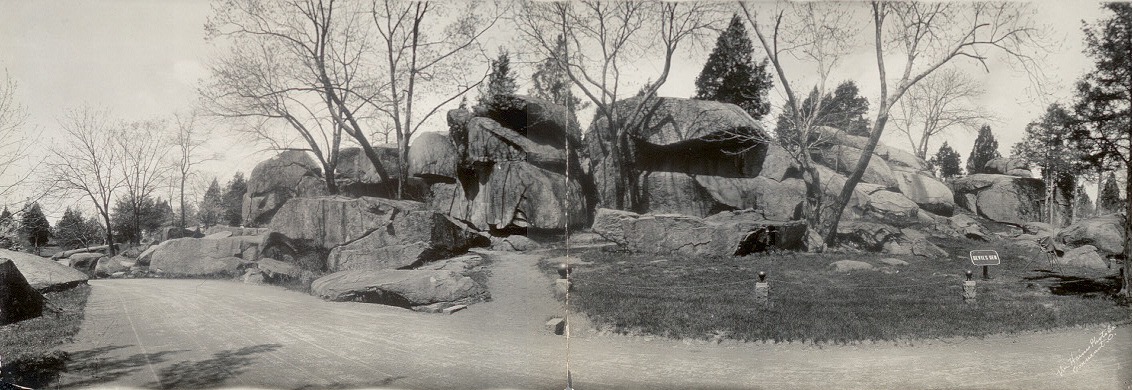
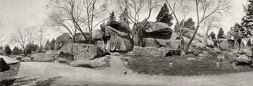 1909 photo of Devil‘s Den
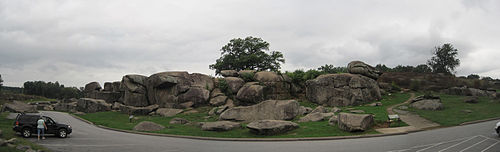 2011 photo of Devil’s DenThis article is about the landform on the south end of Houck's Ridge. For other uses, see Devil's Den (disambiguation).
Devils Den[1] is a boulder-strewn Gettysburg Battlefield hill used by artillery and infantry (e.g., snipers) during the 1863 Battle of Gettysburg, Second Day. A visitor attraction since the memorial association era, several boulders are worn from foot traffic and the site includes numerous cannon, memorials, and walkways, including a bridge spanning 2 boulders.
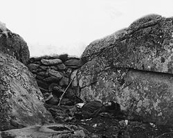 Post-battle Confederate sharpshooter body staged[2] behind the "Devil's Den barricade" illustrating "a sharpshooter…of Devil's Den" such as the one presumed killed by a percussion of a cannon shot from Little Round Top after Weed and Hazlett had been sniped.[3]
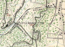 Devils Den (left) is across Sickles Av & Plum Run from the trolley railbed.
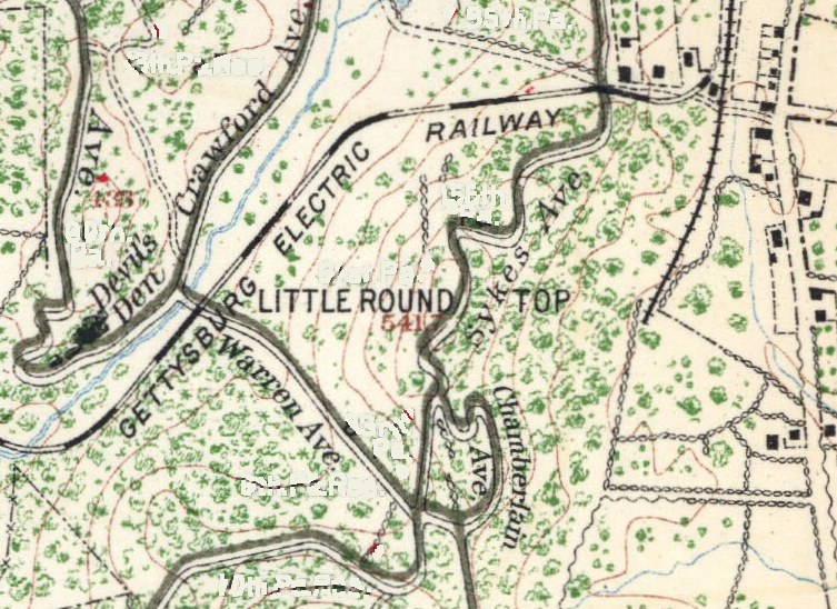
History
Devils Den was formed with Little Round Top (to the east-northeast) and Big Round Top (southwest) by periglacial frost wedging of the igneous landform formed 200 million years ago when the "outcrop of the Gettysburg sill" intruded through the Triassic "Gettysburg plain".[4]:13 After c. 1855 for 25 years through 1881, a 15 ft (4.6 m) snake had been reported between the Emmitsburg Road & Devils Den,[5] and the 1898 black snake was only 8 ft (2.4 m).[1] Named before the battle,[6] some soldiers' accounts used the name "Devil's Cave",[citation needed] and a depression on a boulder that collects water resembles a flying horned bat.[citation needed]
- Battle of Gettysburg
- On July 2, 1863, Smith's Union battery used the hill to counterfire on Confederate artillery prior to McLaws' Assault at 5:30 pm.[7] Against Hood's Assault that started at 4 pm, Devils Den was defended by Birney's 1st Division as the far left position from The Peach Orchard Salient of the the III Corps. The hill was captured when the "First Texas Regiment, having pressed forward to the crest of the hill and driven the enemy from his battery",[8] and Anderson's Confederates used the hill for the first attack on The Wheatfield. From near the Slaughter Pen, the 40th New York Volunteer Infantry Regiment forced the 2nd & 17th Georgia regiments of Benning's Brigade to retreat to Devils Den.[9]
The 124th NY monument with Ellis statue was dedicated near Devil's Den in 1884.[2] Postbellum avenues were constructed to Devil's Den such as Sickles' Avenue from the west, Crawford Avenue in 1895 (north),[10]:'95 and Warren Avenue across Plum Run (east). From 1894-1916, the Gettysburg Electric Railway operated on a curve crossing Plum Run (Rock Creek) around the south base of the hill with the Tipton Station providing Devil's Den services.[3] In 1916, a Devil's Den boulder was used as a Satterlee Hospital memorial at Philadelphia's Clark Park.[11]
The nearby 1933 comfort station was demolished in 2009, and its access bridge over Plum Run remains to the east. In 1952, ROTC students conducted a mock battle at the site,[4] and the "Devil's Den Access Committee" was formed in 1988.[5] The site's ID Tablet was designated a Historic District Contributing Structure in 2004,[12] and the Devil's Den barricade is structure WA35 on the Gettysburg National Military Park's List of Classified Structures.
 External images
Library of Congress images 1933-2009 comfort station Gettysburg Granite comfort station References
- ^ a b "Devils Den". Geographic Names Information System, U.S. Geological Survey. http://geonames.usgs.gov/pls/gnispublic/f?p=gnispq:3:::NO::P3_FID:1173200. Retrieved September 16, 2011.
- ^ Groves, James C. (1998). "The Devil's Den Sharpshooter Re-Discovered". JamesCGroves.com. http://www.jamescgroves.com/henry/hcp1a.htm. Retrieved 2011-10-24.
- ^ "Little Round-Top" (Google News Archive). Gettysburg Compiler. October 24, 1899. http://news.google.com/newspapers?id=IuMyAAAAIBAJ&sjid=1QAGAAAAIBAJ&pg=5845%2C7540002. Retrieved 2011-10-24. "Just before Gen. Crawford made his charge … Gen. Weed said to me: "Martin, I would rather die on this spot than see those rascals gain one inch of ground. I … started to go down…and saw…Weed, reeling and falling to the ground. … [from] Little Round Top … Rittenhouse had a perfect enfilading fire into Pickett's right flank and used it to the best possible advantage."
- ^ Brown, Andrew (1962). "GEOLOGY and the Gettysburg Campaign". Pennsylvania: Bureau of Topographic and Geologic Survey. http://www.dcnr.state.pa.us/topogeo/education/es5/es5.pdf. Retrieved 2010-02-19.
- ^ "Famous Snake" (Google News Archive). Gettysburg Times (Times and News Publishing Company). Jan 23, 1932. http://news.google.com/newspapers?id=qcQlAAAAIBAJ&sjid=m_UFAAAAIBAJ&pg=4283,1140597&dq=round-top+quarry+gettysburg&hl=en. Retrieved 2011-03-15. "In September, 1881, the shy blacksnake of Round Top was seen by Hiram Warren, who states his length to be fifteen feet. For over a quarter century this reptile has been known to reside in this neighborhood."
- ^ Bachelder, John B. (1873). Gettysburg: What to See and How to See It. p. tbd[verification needed]. "it was a name given to the locality before the battle." (quoted by Adelman and Smith, p. 7)
- ^ Hunt, Henry J (Civil War Reference transcript). The Second Day at Gettysburg…. http://www.civilwarreference.com/articles/detail.php?article=129. Retrieved 2011-10-22. "A cross-road connecting the Taneytown and Emmitsburg roads runs along the northern base of Devil's Den. From its Plum Run crossing to the Peach Orchard is 1100 yards. For the first 400 yards of this distance, there is a wood on the north and a wheat-field on the south of the road, beyond which the road continues for 700 yards to the Emmitsburg road along Devil's Den ridge, which slopes on the north to Plum Run, on the south to Plum Branch. [Rose Run] … The angle at the Peach Orchard is thus formed by the intersection of two bold ridges, one from Devil's Den, the other along the Emmitsburg road"
- ^ CSA Brig. Gen. Jerome B. Robertson, after action report, Devil's Den
- ^ Gottfried, Bradley M (Google Books). Brigades of Gettysburg. http://books.google.com/books?id=IODnzEYdAoYC&pg=PA205. Retrieved 2011-05-25.
- ^ Gettysburg National Military Park Commission. The Gettysburg Commission Reports. Gettysburg, PA: War Department. http://www.gdg.org/Research/Authored%20Items/BCRReports/{{{version}}}.html.
- ^ Collins, Jaffe, et al (April 2001-draft). Clark Park Revitalization Project (Report). Philadelphia, Pennsylvania: Friends of Clark Park / University City District. p. 5. http://www.clarkpark.info/Misc%20PDFs/ClarkParkMasterPlanApril2001%20smaller.pdf. Retrieved 2010-09-22.
- ^ Cope, Emmor, "Devil's Den - Cast Iron Site ID Tablet", (structure ID 73, LCS ID tbd) List of Classified Structures: GETT p. tbd (National Park Service), http://www.hscl.cr.nps.gov/insidenps/report.asp?PARK=GETT&RECORDNO=211, retrieved tbd
Battle of Gettysburg Background Civil War · Eastern Theater (Pennsylvania, Adams County) · Campaign (template, box, category) · Battlefield (timeline) · Armies (Northern Virginia, Potomac) · Leaders/Orders of battle (Confederate, Union)
Engagements 1st day (a.m., p.m.) · 2nd day: Assaults (Hood, Mclaws, Anderson), Ewell's demonstration · 3rd day: Longstreet's Assault (Artillery barrage, Pickett's Charge), East cavalry battle, Well's cavalry charge
Combat
areasAngle (Copse of trees, High-water mark) · Barlow Knoll · Biesecker Woods · Big Round Top · Borough · Cavalry fields (East, South) · Cemetery Hill · Cemetery Ridge · Culp's Hill · Devil's Den · Evergreen Cemetery · Little Round Top · McAllister's Hill · McMillan Woods · McPherson's Ridge · Oak Ridge · Pardee Field · Peach Orchard · Pitzer Woods · Plum Run · Railway cut · Seminary Ridge · Slaughter Pen · Spangler Spring · Spangler Woods · Stevens Creek · Triangular Field · Valley of Death · Warfield Ridge · Weikert Hill · Wheatfield · Zeigler's Grove
Aftermath Retreat · Camp Letterman · Soldier's Cemetery (Everett Oration & Gettysburg Address) · Memorial Association · Monuments (CSA) · Reunions (1888 25th, 1913 50th, 1938 75th) · 1895 National Park (parkitecture) · 1975 Historic District · 1962 Cyclorama Bldg · 2008 Museum & Visitor Center · Coins (1936 half, 2011 quarter)
Media 1883 cyclorama · 1898 poem · Films: 1913 (lost), 1955 documentary, 1993, 2011 documentary · The Killer Angels · Gettysburg: A Novel… · The Death Merchant (TV episode) · Gettysburg (The Outer Limits) · The Wheatfield At Gettysburg (TV)
Games Gettysburg · Gettysburg (1863) · Cemetery Hill (game) · Sid Meier's Gettysburg! · Terrible Swift Sword · Battleground 2: Gettysburg · Devil's Den (game) · Enduring Valor: Gettysburg in Miniaturedisambiguation · Gettysburg textbooks from Wikibooks · Gettysburg news stories from Wikinews · Gettysburg images and media from Commons Categories:- Hills of Pennsylvania
- Landforms of Adams County, Pennsylvania
- Places of the Gettysburg Battlefield


Wikimedia Foundation. 2010.