- North Fork John Day River
-
North Fork John Day River 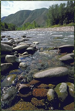 In the North Fork John Day Wilderness
Name origin: John Day, fur trapper Country United States State Oregon County Grant County, Umatilla County Source - location Blue Mountains near Mount Ireland, Grant County, Oregon - elevation 7,466 ft (2,276 m) [1] - coordinates 44°51′48″N 118°14′13″W / 44.86333°N 118.23694°W [2] Mouth John Day River - location Kimberly, Grant County, Oregon - elevation 1,834 ft (559 m) [2] - coordinates 44°45′22″N 119°38′19″W / 44.75611°N 119.63861°W [2] Length 107 mi (172 km) [3][4] Basin 1,800 sq mi (4,662 km2) [5] Discharge for Monument, Oregon, 15.3 miles (24.6 km) from mouth - average 1,287 cu ft/s (36 m3/s) [6] - max 33,400 cu ft/s (946 m3/s) - min 6 cu ft/s (0 m3/s) 
 Location of the mouth of the North Fork John Day River in Oregon
The North Fork John Day River is a 107-mile (172 km) tributary of the John Day River in the U.S. state of Oregon. It begins in Grant County about 20 miles (32 km) northwest of Baker City near the crest of the Blue Mountains. It flows generally west to the community of Dale on U.S. Route 395 then southwest through the city of Monument to the unincorporated community of Kimberly, where it meets the main stem of the John Day River.
The upper reaches of the river flow through the North Fork John Day Wilderness in the Wallowa-Whitman National Forest and the Umatilla National Forest. From its headwaters to its confluence with Camas Creek, the river is part of the National Wild and Scenic River system. The upper 27.8 miles (44.7 km) is classified wild, the next 10.5 miles (16.9 km) scenic, and the next 15.8 miles (25.4 km) recreational for a total of 54.1 miles (87.1 km).[7]
The North Fork John Day River is one of the most important in northeast Oregon for anadromous fish. Wildlife found near the river includes mule deer, elk, and black bears, Peregrine Falcons, and Bald Eagles. Recreational uses include hunting, fishing, horseback riding, hiking, snowmobiling, skiing, camping, and whitewater rafting.[7]
See also
- List of rivers of Oregon
- List of longest streams of Oregon
- List of National Wild and Scenic Rivers
References
- ^ Source elevation derived from Google Earth search using GNIS source coordinates.
- ^ a b c "North Fork John Day River". Geographic Names Information System (GNIS). United States Geological Survey (USGS). November 28, 1980. http://geonames.usgs.gov/pls/gnispublic/f?p=gnispq:3:::NO::P3_FID:1146969. Retrieved September 1, 2008.
- ^ Length from mouth to Camas Creek. "Online Topographic Maps from the United States Geological Survey". TopoQuest. http://www.topoquest.com/map.php?lat=45.0071801822&lon=-118.985658522&datum=nad83&zoom=4&map=auto&coord=d&mode=zoomin&size=m. Retrieved September 1, 2008.
- ^ Length from Camas Creek to source. "North Fork John Day River, Oregon". Public Lands Information Center. http://www.publiclands.org/explore/site.php?id=3544&PHPSESSID=23cfeb7c9. Retrieved September 1, 2008.
- ^ Macy, Tom; James, Gary (2000). "North Fork John Day River Basin Anadromous Fish Enhancement Project". Bonneville Power Administration. http://pisces.bpa.gov/release/documents/documentviewer.aspx?pub=H00006613-1.pdf. Retrieved September 3, 2008.
- ^ "Water-Data Report 2007: 14046000 North Fork John Day River at Monument, OR" (pdf). United States Geological Survey (USGS). 2007. http://wdr.water.usgs.gov/wy2007/pdfs/14046000.2007.pdf. Retrieved September 1, 2008.
- ^ a b "North Fork John Day River". U.S. National Wild and Scenic Rivers System. 2008. http://www.rivers.gov/wsr-john-day-north.html. Retrieved September 2, 2008.
Categories:- Rivers of Oregon
- Wild and Scenic Rivers of the United States
- Landforms of Grant County, Oregon


Wikimedia Foundation. 2010.