- Oberhavel
-
Oberhavel — District — 
Country  Germany
State Brandenburg Capital Oranienburg Area - Total 1,795.3 km2 (693.2 sq mi) Population (31 December 2010)[1] - Total 203,124 - Density 113.1/km2 (293/sq mi) Time zone CET (UTC+1) - Summer (DST) CEST (UTC+2) Vehicle registration OHV Website http://www.oberhavel.de Oberhavel is a Kreis (district) in the northern part of Brandenburg, Germany. Neighboring districts are (from north clockwise) Mecklenburg-Strelitz in Mecklenburg-Western Pomerania, the districts Uckermark, Barnim, the Bundesland Berlin, and the districts Havelland and Ostprignitz-Ruppin.
Contents
Geography
The district is located along the upper course of the Havel river from its source to the outskirts of Berlin. The north is characterised by many lakes including the Großer Stechlinsee lake, which is well known due to a novel by Theodor Fontane called "Der Stechlin".
History
The district was created on December 6 1993 by merging the previous districts Gransee and Oranienburg.
Coat of arms
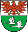
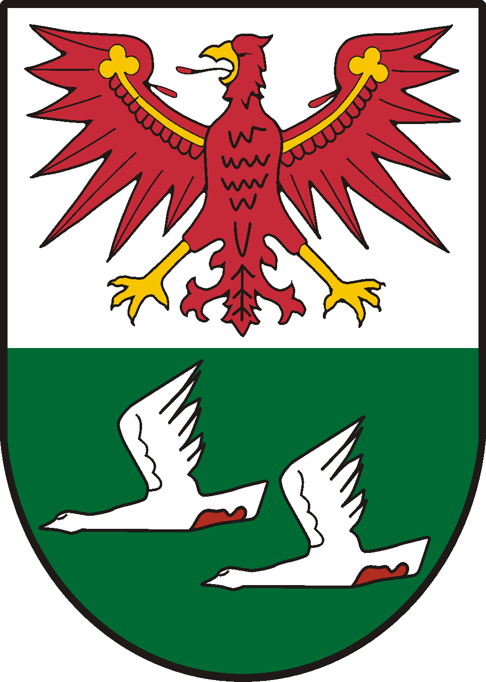
The coat of arms shows the eagle as the symbol of Brandenburg in the top part. In the bottom are two flying swans on green backbround representing the nature with many lakes. The coat of arms was unofficially used by the precursor district Oranienburg before the merging, but was never officially granted. It was granted to the district Oberhavel on May 18, 1994. Towns and municipalities
Towns Ämter free municipalities 1seat of the Amt; 2town
Sport
The district is home to three rugby union clubs, the RU Hohen Neuendorf, Veltener RC and Stahl Hennigsdorf Rugby. The later was the most successful rugby club in East Germany, winning 27 national championships from 1952 to 1990.[2]
References
- ^ "Bevölkerung im Land Brandenburg am am 30. Dezember 2010 nach amtsfreien Gemeinden, Ämtern und Gemeinden. Gebietsstand: 31.12.2010" (in German). Amt für Statistik Berlin-Brandenburg. 31 December 2010. http://www.statistik-berlin-brandenburg.de//Publikationen/OTab/2011/OT_A01-04-00_124_201012_BB.pdf.
- ^ Rugby in Hennigsdorf - Eine Chronologie (German) Stahl Hennigsdorf website - club history, accessed: 10 April 2010
External links
 Media related to Oberhavel at Wikimedia Commons
- Official website (German)
Urban districts Rural districts Barnim · Dahme-Spreewald · Elbe-Elster · Havelland · Märkisch-Oderland · Oberhavel · Oberspreewald-Lausitz · Oder-Spree · Ostprignitz-Ruppin · Potsdam-Mittelmark · Prignitz · Spree-Neiße · Teltow-Fläming · UckermarkCategories:- Districts of Brandenburg
- Oberhavel
Wikimedia Foundation. 2010.