- Oranienburg
-
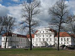
Oranienburg Schloss Oranienburg 
Coordinates 52°45′16″N 13°14′13″E / 52.75444°N 13.23694°ECoordinates: 52°45′16″N 13°14′13″E / 52.75444°N 13.23694°E Administration Country Germany State Brandenburg District Oberhavel Town subdivisions 9 districts Mayor Hans-Joachim Laesicke (SPD) Basic statistics Area 162.37 km2 (62.69 sq mi) Elevation 34 m (112 ft) Population 41,810 (31 December 2010)[1] - Density 257 /km2 (667 /sq mi) Other information Time zone CET/CEST (UTC+1/+2) Licence plate OHV Postal code 16515 Area code 03301 Website www.oranienburg.de Oranienburg is a town in Brandenburg, Germany. It is the capital of the district of Oberhavel.
Contents
Geography
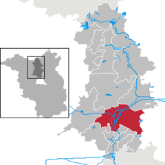
Oranienburg is a town located on the banks of the Havel river, 35 km north of the centre of Berlin.
Division of the town
Oranienburg consists of 9 districts
- Friedrichsthal
- Germendorf
- Lehnitz
- Malz
- Oranienburg
- Sachsenhausen
- Schmachtenhagen
- Wensickendorf
- Zehlendorf
History
The original name of Oranienburg was Bötzow. The town was founded in the 12th century and was first mentioned in 1216. Albert the Bear is believed to have ordered the construction of a castle on the banks of the Havel. Around the castle there was a settlement of traders and craftsmen.
In 1646, Friedrich Wilhelm I of Brandenburg married Louise Henriette of Orange-Nassau (German: Oranien-Nassau). She was so attracted by the town of Bötzow, that her husband presented the entire region to her. The princess ordered a new castle to be built in the Dutch style and called it Oranienburg or Schloss Oranienburg. In 1653, the town of Bötzow was renamed Oranienburg.
One of the first Nazi concentration camps was built in Oranienburg in 1933. In 1935 it was replaced by the Sachsenhausen concentration camp which continued to operate until the end of the Nazi regime; 100,000 people were killed in Sachsenhausen before the liberation of the camp by the Soviet Red Army in 1945.
Oranienburg was also the center of Nazi Germany's nuclear energy project and according to military historian Antony Beevor, the launching of the Battle for Berlin by Stalin was motivated by his desire to acquire that facility.[2] It has also been claimed that the preemptive destruction of these facilities by the USAAF Eighth Air Force on March 15, 1945, was done so as to prevent it from falling into Soviet hands.[3]
International relations
Oranienburg is twinned with:
 Bagnolet (France) -- since 1964
 Hamm (North Rhine-Westphalia, Germany) -- since 1990
 Mělník (Czech Republic) -- since 1974
 Vught (Netherlands) -- since 2000
 Friedrichsthal (Saarland, Germany) -- since 1991
Public institutions
The Zehlendorf transmission facility, a large facility for broadcasting in longwave, medium wave and FM-range, is located near Oranienburg, at Zehlendorf.
See also
- Oranienburg railway station
- Stellwerk Fichtengrund
Footnotes
- ^ "Bevölkerung im Land Brandenburg am am 30. Dezember 2010 nach amtsfreien Gemeinden, Ämtern und Gemeinden. Gebietsstand: 31.12.2010" (in German). Amt für Statistik Berlin-Brandenburg. 31 December 2010. http://www.statistik-berlin-brandenburg.de//Publikationen/OTab/2011/OT_A01-04-00_124_201012_BB.pdf.
- ^ Antony Beevor Berlin: The Downfall 1945, Penguin Books, 2002, ISBN 0-670-88695-5 Preface xxxiv
- ^ Richard G. Davis,Bombing the European Axis Powers. A Historical Digest of the Combined Bomber Offensive 1939–1945 Alabama: Air University Press, 2006, page 518
External links
 Media related to Oranienburg at Wikimedia Commons
- Official site (German)
Birkenwerder | Fürstenberg/Havel | Glienicke/Nordbahn | Gransee | Großwoltersdorf | Hennigsdorf | Hohen Neuendorf | Kremmen | Leegebruch | Liebenwalde | Löwenberger Land | Mühlenbecker Land | Oberkrämer | Oranienburg | Schönermark | Sonnenberg | Stechlin | Velten | ZehdenickCategories:- Towns in Brandenburg
- Oranienburg
- Localities in Oberhavel
Wikimedia Foundation. 2010.


