- Mountain Valley Airport
-
Mountain Valley Airport 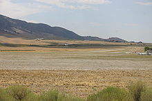
Tow plane and glider taking off IATA: none – ICAO: none – FAA LID: L94 Summary Airport type Public use Owner Larry G. Barrett Serves Tehachapi, California Elevation AMSL 4,220 ft / 1,286 m Coordinates 35°06′04″N 118°25′23″W / 35.10111°N 118.42306°W Runways Direction Length Surface ft m 9L/27R 4,890 1,490 Asphalt/Dirt 9R/27L 4,890 1,490 Asphalt/Dirt Statistics (2011) Aircraft operations 50,000 Based aircraft 98 Source: Federal Aviation Administration[1] Mountain Valley Airport (FAA LID: L94) is a privately-owned public-use airport located two nautical miles (4 km) southeast of the central business district of Tehachapi, in Kern County, California, United States.[1][2]
The airport is used for glider operations and training.[3][4][5] It was established for its close proximity to various advantageous lift effects for soaring where the Sierra Nevada Mountains, Tehachapi Mountains and the Mojave Desert meet.
The Skylark North Glider School performs glider flight training for civilians as well as for the US Air Force Test Pilot School (from Edwards AFB), the National Test Pilot School (from the Mojave Air & Space Port), NASA and others. Due to the ongoing training contract with the US Air Force Test Pilot School, probably most or nearly all NASA Space Shuttle pilots who came from the Air Force have received glider training at Mountain Valley Airport.[6]
Contents
Facilities and aircraft
Mountain Valley Airport covers an area of 170 acres (69 ha) at an elevation of 4,220 feet (1,286 m) above mean sea level. It has two runways designated 9L/27R and 9R/27L, each with an asphalt and dirt surface measuring 4,890 by 36 feet (1,490 x 11 m).[1]
For the 12-month period ending May 2, 2011, the airport had 50,000 aircraft operations, an average of 136 per day: 98% general aviation and 2% military. At that time there were 98 aircraft based at this airport: 82% glider and 18% single-engine.[1]
There are a sandwich shop and an RV park & campground on field. The nearest fuel sales are at Tehachapi Municipal Airport 2 miles to the north.
See also
References
- ^ a b c d FAA Airport Master Record for L94 (Form 5010 PDF). Federal Aviation Administration. Effective 25 August 2011.
- ^ "Mountain Valley Airport". Geographic Names Information System, U.S. Geological Survey. http://geonames.usgs.gov/pls/gnispublic/f?p=gnispq:3:::NO::P3_FID:1654045. Retrieved 4 May 2009.
- ^ "Mountain Valley Airport". Skylark North Glider School. December 2004. Archived from the original on 10 May 2008. http://web.archive.org/web/20080510193858/http://www.tehachapi.com/glider/home.htm. Retrieved 14 August 2008.
- ^ "Where to Fly - Mountain Valley Airport - Tehachapi, CA". Soaring Society of America. http://www.ssa.org/sport/op_text.asp?site=131. Retrieved 14 August 2008.
- ^ "Places to Soar in Southern California". socalsoaring.com (Sean Ford). 2006. http://www.socalsoaring.com/index.php?page=sites. Retrieved 14 August 2008.
- ^ Hawkins, Dale. "Mountain Valley Airport – Tehachapi's Soaring Airport". Tehachapi Skywatch column (Tehachapi News). http://www.tehachapinews.com/home/ViewPost/19659. Retrieved 2008-08-14.
External links
- "Vintage Charmers" by Chad Slattery, March 2005, Air & Space Magazine, Smithsonian Institution
- Federal contracts by Skylark North Glider School, at fedspending.org
- Aerial image as of 4 October 1995 from USGS The National Map
- Resources for this airport:
- AirNav airport information for L94
- FlightAware airport information and live flight tracker
- SkyVector aeronautical chart for L94
Categories:- Airports in Kern County, California
- Gliderports in the United States

Wikimedia Foundation. 2010.