- Crawfordsville, Oregon
-
Crawfordsville — Unincorporated community — Covered bridge in Crawfordsville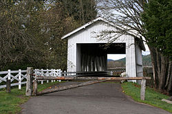 Location within the state of Oregon
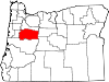
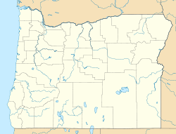
 Crawfordsville
Coordinates: 44°21′25″N 122°51′28″W / 44.35694°N 122.85778°WCoordinates: 44°21′25″N 122°51′28″W / 44.35694°N 122.85778°W Country United States State Oregon County Linn Time zone Pacific (PST) (UTC-8) – Summer (DST) PDT (UTC-7) ZIP codes 97336 FIPS code GNIS feature ID Crawfordsville is an unincorporated community in Linn County, Oregon, United States. Although it is unincorporated, it has a post office with a ZIP code of 97336.[1] Crawfordsville lies on Oregon Route 228 between Brownsville to the west and Sweet Home to the east.
References
Municipalities and communities of Linn County, Oregon Cities Albany‡ | Brownsville | Gates‡ | Halsey | Harrisburg | Idanha‡ | Lebanon | Lyons | Mill City‡ | Millersburg | Scio | Sodaville | Sweet Home | Tangent | Waterloo
CDP Unincorporated
communitiesCascadia | Crabtree | Crawfordsville | Foster | Jordan | Kingston | Lacomb | Marion Forks | New Idanha | Riverside | Santiam Junction | Shedd
Footnotes ‡This populated place also has portions in an adjacent county or counties
Categories:- Census-designated places in Oregon
- Unincorporated communities in Linn County, Oregon
- Oregon geography stubs


Wikimedia Foundation. 2010.