- Brownsville, Oregon
Infobox Settlement
official_name = Brownsville, Oregon
settlement_type =City
nickname =
motto =
imagesize =
image_caption =
image_
imagesize =
image_caption =
image_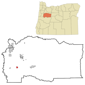
mapsize = 250px
map_caption = Location inOregon
mapsize1 =
map_caption1 =
subdivision_type = Country
subdivision_name =United States
subdivision_type1 = State
subdivision_name1 =Oregon
subdivision_type2 = County
subdivision_name2 = Linn
government_type =
leader_title =Mayor
leader_name = Don Ware
established_title = Incorporated
established_date =1876
area_magnitude =
area_total_sq_mi = 1.3
area_total_km2 = 3.4
area_land_sq_mi = 1.3
area_land_km2 = 3.4
area_water_sq_mi = 0
area_water_km2 = 0
area_urban_sq_mi =
area_urban_km2 =
area_metro_sq_mi =
area_metro_km2 =
population_as_of =2007
population_note =
population_total = 1755
population_metro =
population_urban =
population_density_km2 = 430.4
population_density_sq_mi = 1116.2
timezone = Pacific
utc_offset = -8
timezone_DST = Pacific
utc_offset_DST = -7
latd = 44 |latm = 23 |lats = 36 |latNS = N
longd = 122 |longm = 59 |longs = 1 |longEW = W
elevation_m = 80.77
elevation_ft = 265
website = http://www.ci.brownsville.or.us/
postal_code_type =ZIP code
postal_code = 97327
area_code = 541
blank_name = FIPS code
blank_info = 41-09050GR|2
blank1_name = GNIS feature ID
blank1_info = 1118140GR|3
footnotes =Brownsville is a city in Linn County,
Oregon ,United States . The population was 1,449 at the 2000 census. The 2007 estimate is 1,755 residents. [http://www.pdx.edu/media/p/r/prcCertifiedRelease_07_web_cities.pdf PSU:Population Research Center] ] It is the setting for the fictional Castle Rock, Oregon in the film Stand by Me.Geography
Brownsville is located at coor dms|44|23|36|N|122|59|1|W|city (44.393286, -122.983718)GR|1.
According to the
United States Census Bureau , the city has a total area of 1.3square mile s (3.4km² ), all of it land.Demographics
As of the
census GR|2 of 2000, there were 1,449 people, 535 households, and 411 families residing in the city. Thepopulation density was 1,116.2 people per square mile (430.4/km²). There were 579 housing units at an average density of 446.0/sq mi (172.0/km²). The racial makeup of the city was 93.65% White, 0.35% African American, 1.66% Native American, 0.14% Asian, 0.55% from other races, and 3.66% from two or more races. Hispanic or Latino of any race were 2.07% of the population.There were 535 households out of which 35.5% had children under the age of 18 living with them, 60.4% were married couples living together, 10.8% had a female householder with no husband present, and 23.0% were non-families. 19.4% of all households were made up of individuals and 8.8% had someone living alone who was 65 years of age or older. The average household size was 2.71 and the average family size was 3.07.
In the city the population was spread out with 27.5% under the age of 18, 7.5% from 18 to 24, 26.4% from 25 to 44, 27.0% from 45 to 64, and 11.6% who were 65 years of age or older. The median age was 37 years. For every 100 females there were 102.1 males. For every 100 females age 18 and over, there were 98.9 males.
The median income for a household in the city was $35,486, and the median income for a family was $39,671. Males had a median income of $37,400 versus $24,643 for females. The
per capita income for the city was $15,272. About 5.6% of families and 8.8% of the population were below thepoverty line , including 11.0% of those under age 18 and 7.4% of those age 65 or over.References
External links
* [http://www.ci.brownsville.or.us/ City of Brownsville] (official website)
* [http://www.historicbrownsville.com/ Brownsville Chamber of Commerce]
Wikimedia Foundation. 2010.