- Mafra, Santa Catarina
-
Mafra — Municipality — The Municipality of Mafra 
Flag
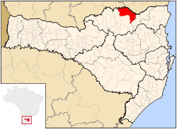
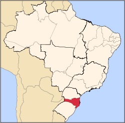
SealMotto: Pérola do Planalto Location in the State of Santa Catarina Coordinates: 26°06′39″S 49°48′18″W / 26.11083°S 49.805°W Country  Brazil
Region South State  Santa Catarina
Founded September 8, 1917 Government - Mayor João Alfredo Herbst (PMDB) Area - Total 1,404.206 km2 (872.533 sq mi) Elevation 793 m (2,601.7 ft) Population (2007) - Total 51,014 - Density 36.32/km2 (58.47/sq mi) Time zone UTC-3 (UTC-3) - Summer (DST) UTC-2 (UTC-2) HDI (2000) 0.788 Website Mafra City Hall Mafra is a city located in the northern border of the state of Santa Catarina, Brazil. This city borders to the state of Paraná and its urban area is attached to the urban area of its interstate neighbour, Rio Negro. This city's population is composed primarily of descendants of European immigrants, especially from Germany and Poland. This city is also known for its honey, which is said to have excellent quality.
-
ForumMafra.jpg
Coordinates: 26°07′S 49°48′W / 26.117°S 49.8°W
Norte Catarinense mesoregion of Santa Catarina  , Brazil
mesoregions of Santa Catarina: Grande Florianópolis • Norte Catarinense • Oeste Catarinense • Serrana • Sul Catarinense • Vale do Itajaí Canoinhas Bela Vista do Toldo • Canoinhas • Irineópolis • Itaiópolis • Mafra • Major Vieira • Monte Castelo • Papanduva • Porto União • Santa Terezinha • Timbó Grande • Três BarrasJoinville Araquari • Balneário Barra do Sul • Corupá • Garuva • Guaramirim • Itapoá • Jaraguá do Sul • Joinville • Massaranduba • São Francisco do Sul • SchroederSão Bento do Sul Categories:- Populated places in Santa Catarina (state)
- Santa Catarina geography stubs
-
Wikimedia Foundation. 2010.


