- Copmanthorpe
-
Coordinates: 53°54′58″N 1°07′59″W / 53.916°N 1.133°W
Copmanthorpe 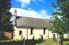
St Giles Church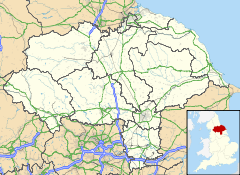
 Copmanthorpe
Copmanthorpe shown within North YorkshirePopulation 4,262 (2001 census) OS grid reference SE5747 Parish Copmanthorpe Unitary authority City of York Ceremonial county North Yorkshire Region Yorkshire and the Humber Country England Sovereign state United Kingdom Post town YORK Postcode district YO23 Dialling code 01904 Police North Yorkshire Fire North Yorkshire Ambulance Yorkshire EU Parliament Yorkshire and the Humber UK Parliament York Outer List of places: UK • England • Yorkshire Copmanthorpe is a village and civil parish in the City of York in the English county of North Yorkshire, 4 miles (6.4 km) south west of York, west of Bishopthorpe and close to Acaster Malbis, Askham Bryan and Askham Richard. According to the 2001 census the parish had a population of 4,262. Until 1996 it had been part of the Selby district. The village is part of the York Outer constituency.[1]
The village is mentioned in the Domesday Book as Copemantorp, from Old Norse Kaupmanna þorp, meaning Traders’ Village or Craftsmen’s Village.[2] The area of Copmanthorpe covering Main Street, Church Street and Low Green became a Conservation Area in 1978.[3]
Copmanthorpe is bounded to the north by the A64, while the East Coast Main Line runs through its south-east periphery, to the west lies open countryside.
Contents
History
The Roman road from York (Eboracum) to Tadcaster (Calcaria) runs to the north of the village centre, along what are now Top Lane, Hallcroft Lane and Colton Lane.
It is recorded that the Lord of Copmanthorpe Manor was an Anglo-Saxon, named Gospatrick, at the time of the Norman invasion of England. According to the Domesday book, the title was handed to Erneis de Burun in 1084, when he became Sherriff of Yorkshire.
Copmanthorpe was the site of a preceptory of the Knights Templar, on land given to the Templar Knights by the Malbis family (see Acaster Malbis). A Preceptor, Robert de Reygate, of the Temple is recorded as early as 1291 In 1672 the manor was sold to the Wood family.
The Copmanthorpe rail crash was a railway accident that occurred on 25 September 2006. One person was killed when the 14:25 Plymouth to Edinburgh Virgin Cross Country service collided with a car that had veered off Moor Lane and onto the tracks, causing the front carriage of the Voyager train set to derail and the car driver to die. The accident happened at approximately 21:01 BST. The train involved was already running late on its journey towards York.
Governance
The village is part of the Rural West Ward of the Unitary Authority of the City of York. As of 2011, it is represented on the City Council by Councillors Ian Gillies, Paul Healey and Chris Steward who are all members of the local Conservative Party.[4]
Geography
Copmanthorpe lies 4 miles south-west of York City Centre. The village lies on Glacial Moraine of sandstone overlain with boulder clay. The highest point of the village is on Top Lane at 81 feet above sea level. The village has two greens, Low Green and the smaller Memorial Green.
Demography
The population of the village has almost trebled over the past hundred years since the first census in 1881, rising from 311 in 1881 to 1,027 in 1961.[5] In the 2001 census the village parish notes the population as 4,262. The largest Age Group within the population, 30.5% between 45 and 64 years old with 26.1% were between 30 and 44 years old. Of the population aged between 16 and 74 years old, 69.3% declared they were in some form of employment and 25.3 % said they were retired. Of the 1,699 households, 35% were Semi-Detached or terraced and 64.3% were Detached. The level of household ownership was 91%.[6]
Economy
Originally the village was a place for tradesmen and farming, but currently Copmanthorpe is a functional commuter village, with two churches, a post-office, a butchers, a library, a coffee shop, newsagents, two hair dressers, pharmacy, a small food shop, one pub, and several takeaways.[7]
Culture and community
Copmanthorpe Recreation Centre (”the Rec”) provides most of the sporting and many of the social facilities in the village. It is a registered charity for the benefit of the whole village. There is also a children's play area with a variety of equipment on a safety surface.[8] Allotments, with fifty four plots, can be found on Temple Lane and are run by Copmanthorpe Parish Council.[9]
There are numerous village functions throughout the year, including the Carnival in summer, and the Fayre in Spring. The local branch of the Women's Institute was formed in 1924 and moved into a purpose built Hall in 1928.[3] Other clubs and societies include a Mother's Union, Drama Group, Youth Club and both Scouts and Girl Guide Troops.
Transport
The village is served by one regular local bus service from York and by the Yorkshire Coastliner Service both run by First Group and by one service run by Harrogate Coach Travel as part of the York to Colton route.
There was a railway station in the village that opened in 1839 on the York & North Midland line. The station was closed to passengers in 1959 and closed altogether in 1964.[3] Plans have been put forward to reopen the station along with others in York’s surrounding area, but have failed to materialise as of 2010.[10]
Education
The original village school opened in 1869 on the site now occupied by the health centre.[3] The current junior school, opened in 1968, was designed to take over from the Victorian building, but as the population grew an infants school was also built alongside in 1972.
Primary education is currently catered for at Copmanthorpe Primary School[11] with students usually going to Tadcaster Grammar School, a co-educational Comprehensive School, for their secondary and further education.
Religion
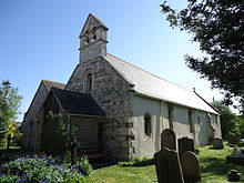 St Giles Church
St Giles Church on Church Street was built in 1180 and much remains of the original Norman design.[3] St Giles did not become a parish church in its own right until 1866, as Copmanthorpe was previously part of the parish of St Mary Bishophill Junior in York. Church Street was also the site of the first Methodist Chapel in the village, around 1788. The modern Chapel was built in 1958 in Main Street by the architects Greenwood and Nicholls.
Sports
There is a dedicated sports area at the Recreation Ground which is the home of Copmanthorpe Football Club and Copmanthorpe Cricket Club. Tennis and bowls are also played at the ground. The Football Club was founded in 1962 and, as of 2010, the 1st XI play in the Premier Division of the York District League and the reserves in the Reserve A Division.[12] As of 2010, the Cricket Club 1st XI play in Division 1 of the York Vale Cricket League with the 2nd X I playing in Division 4.[13]
References
- ^ "Parliamentary Constituencies". City of York Council. http://www.york.gov.uk/council/Elections_and_democracy/constituencies/. Retrieved 30 May 2011.
- ^ Oxford English Dictionary, 2nd Ed.. Oxford: Oxford University Press. 1989. ISBN 0-19-861186-2.
- ^ a b c d e "The Copmanthorpe Story". Copmanthorpe Parish Council. http://www.copmanthorpeparishcouncil.org.uk/wp-content/uploads/2009/04/copmanthorpe-story.pdf. Retrieved 30 May 2011.
- ^ "Find Councillor: Results by Ward: Rural West York Ward". City of York Council. http://democracy.york.gov.uk/mgFindCouncillor.aspx?XXR=0&AC=WARD&WID=362. Retrieved 30 May 2011.
- ^ "Historical Statistics: Population: Copmanthorpe Civil Parish". A Vision of Britain Through Time. University of Portsmouth. http://www.visionofbritain.org.uk/data_cube_page.jsp?data_theme=T_POP&data_cube=N_TOT_POP&u_id=10414891&c_id=10001043&add=N. Retrieved 30 May 2011.
- ^ "Neighbourhood Statistics: Copmanthorpe Civil Parish". Office for National Statistics. http://neighbourhood.statistics.gov.uk/dissemination/LeadTableView.do;jsessionid=ac1f930b30d5b187b6fbb93942559147e633ea597a8d?a=7&b=791161&c=Copmanthorpe&d=16&e=15&g=393013&i=1001x1003x1004&m=0&r=1&s=1306735219885&enc=1&dsFamilyId=779&nsjs=true&nsck=true&nssvg=false&nswid=588. Retrieved 30 May 2011.
- ^ "Shopping". Copmanthorpe: The Parish Council Website. Copmanthorpe Parish Council. http://www.copmanthorpeparishcouncil.org.uk/?page_id=44. Retrieved 30 May 2011.
- ^ "Play Areas". City of York Council. http://www.york.gov.uk/environment/Parks_and_open_spaces/playgrounds/. Retrieved 30 May 2011.
- ^ "Other Allotments in York". City of York Council. http://www.york.gov.uk/environment/Parks_and_open_spaces/Allotments/allotments-other/. Retrieved 30 May 2011.
- ^ "York Suburb Station Plan Derailed Again". The Press. Newsquest Media Group. http://www.yorkpress.co.uk/archive/2004/06/18/York+Archive/7885422.York_suburb_station_plan_derailed_again/. Retrieved 30 May 2011.
- ^ "Copmanthorpe Primary School". Copmanthorpe Primary School. http://www.skillspace.com/LearningSystem/PortalHome/Start.asp?Institution=Copmanthorpe&Campus=. Retrieved 30 May 2011.
- ^ "Copmanthorpe: Football Club". Copmanthorpe Football Club. http://www.copmanthorpefc.co.uk/htmlfiles/senior_first.html. Retrieved 30 May 2011.
- ^ "Copmanthorpe Cricket Club". Copmanthorpe Cricket Club. http://www.copmanthorpecricket.co.uk/. Retrieved 30 May 2011.
External links
 Media related to Copmanthorpe at Wikimedia CommonsCategories:
- Villages in North Yorkshire
- Villages and areas in the City of York
- Civil parishes in North Yorkshire


Wikimedia Foundation. 2010.