- U.S. Route 6 in Utah
Infobox road
state=UT
type=US
route=6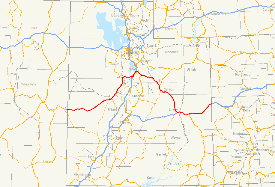
section=106
maint=UDOT
length_mi=373.963
length_round=3
length_ref=Utah Department of Transportation , [http://www.udot.utah.gov/main/f?p=100:pg:7362807272423840:::1:T,V:814, Highway Reference Information] : PDFlink|1= [http://www.udot.utah.gov/main/uconowner.gf?n=6546030094997363 US-6] |2=113 KB, updated May 2008, accessed July 2008]
established=1936
direction_a=West
terminus_a=jct|state=NV|US|6|US|50 towardsEly, NV
junction=
direction_b=East
terminus_b=jct|state=CO|I|70|US|6|US|50 towardsGrand Junction, CO
previous_type=US
previous_route=491
next_type=SR
next_route=8U.S. Route 6 is a major east-weststate highway through the central part of theU.S. state ofUtah . Although it is about convert|40|mi|km longer than US-50, it serves more populated areas, and in fact follows what had been US-50's routing until it was moved to follow I-70 in 1976.Route description
US-6 enters Utah overlapped with US-50 in the
Great Basin , a largedesert that includes much of western Utah. As part of theBasin and Range Province , the terrain alternates between north-south oriented flat valleys and mountain ranges. US-6 and US-50 cross the Snake Valley,Confusion Range (through Kings Canyon),Tule Valley ,House Range (viaSkull Rock Pass ), andPahvant Valley (passing north ofSevier Lake ), finally reaching the town of Hinckley just before they split in Delta. US-6 turns to the northeast at that city, paralleling theUnion Pacific Railroad 'sLynndyl Subdivision to the west of theCanyon Mountains ,Gilson Mountains , andEast Tintic Mountains - three ranges that form the eastern boundary of the Basin and Range Province.Google Maps street maps andUSGS topographic map s, accessed July 2008 via [http://mapper.acme.com/ ACME Mapper] ]At Tintic Junction, the intersection with SR-36 in the
Tintic Valley , US-6 turns east and ascends the East Tintic Mountains. It passes through the mining city of Eureka as it climbs to The Summit, before descending throughHomansville Canyon into theGoshen Valley . Although it left behind the UP rail line at Tintic Junction, this part of US-6 parallels the formerTintic Branch of theDenver and Rio Grande Western Railroad , which has been partially abandoned. After passing through Goshen, the highway curves around the north side ofWarm Springs Mountain and into theUtah Valley , where it enters Santaquin. On the east side of that city, US-6 begins an overlap with I-15, while the old alignment - SR-198 - continues straight through Payson and Salem. After about convert|13|mi|km together in the Utah Valley, US-6 and I-15 separate in Spanish Fork, the latter turning southeast onto a short two-laneexpressway . SR-198 rejoins US-6 on the eastern outskirts of Spanish Fork, and soon thereafter US-89 joins at Moark Junction. The two routes - US-6 and US-89 - begin an overlap here that extends through theSpanish Fork Canyon , alongside the UPProvo Subdivision (ex-D&RGW ), to Thistle in theWasatch Range . The remainder of US-6 to the Colorado state line parallels this rail line (which becomes theGreen River Subdivision at Helper).US-6 continues alone through the Spanish Fork Canyon, now alongside
Soldier Creek , to Soldier Summit on theWasatch Plateau , where it finally leaves the Great Basin into thewatershed of theColorado River . It begins to descend by following the White River, which empties into thePrice River near Colton. The Price River takes US-6 down through thePrice Canyon , the west edge of theBook Cliffs , joining US-191 at Castle Gate. The land flattens and opens out at Helper, named for thehelper locomotive s needed to carry trains up to Soldier Summit, and US-6 continues southeasterly around Price on atwo-lane freeway bypass, with the old alignment marked as both abusiness route and SR-55. Relatively flat land continues as US-6 parallels the Book Cliffs to the southwest and west, crossing the Price River at Woodside. West of Green River, US-6 joins I-70/US-50, which it overlaps for the remainder of its stay in Utah. Now south of the Book Cliffs, the four routes head east to Crescent Junction, where US-191 splits to the south. As it begins to approach the Colorado River, the highway curves northeasterly through the Grand Valley and into Colorado.US-6 forms an arch-shaped route with Spanish Fork at the apex. The western half of the arch is the road less traveled, passing through the
Great Basin desert ,Sevier Lake , Delta, Eureka and the Tintic mining district.The eastern half is a popular transportation corridor, paralleling the
Denver and Rio Grande Western Railroad 's transcontinental line. This half passes over Soldier Summit and the historicrailroad hub of Helper.Starting in the spring of
1983 US-6 was a discontinuous route for almost one year, due to a massive landslide that destroyed the town of Thistle. During this time traffic was routed on 2 detours. One, viaSalina, Utah , was over convert|200|mi|km long and took traffic almost 100 aerial miles from the route of US-6. The other, viaDuchesne, Utah , was shorter. However, this detour traversed steep grades and was not recommended for trucks. The night before the rebuilt US-6 opened, the highway stubs at either side of the landslide were filled with tens of miles of trucks. The drivers tired of the lost revenue from the long detours. The landslide remains the most costly in the history of the United States [ [http://www.media.utah.edu/UHE/t/THISTLE.html Thistle] . "Utah History Encyclopedia"] . Tworest area s along US-6 pay tribute to the residents of the town who lost everything.US-6 in Utah passes through or by several
ghost towns including Tintic, Thistle, Tucker, Soldier Summit, Colton, Woodside and Cisco. Most of these towns were eithermining or railroad based.History
US-6 did not enter Utah until 1936, when it was extended west from
Greeley, Colorado toLong Beach, California . The eastern half in Utah, from Colorado to Spanish Fork, overlapped US-50, but after a short segment on US-91 to Santaquin, it followed a route that was new to theU.S. Highway system into Nevada. This road was not yet built to good standards; while it was improved to Hinckley, the remainder across thedesert was agraded earth road . It was not paved all the way until 1952, when a new alignment was completed from Hinckley into Nevada;Richard F. Weingroff,Federal Highway Administration , [http://www.fhwa.dot.gov/infrastructure/us6.htm U.S. 6: The Grand Army of the Republic Highway] , accessed July 2008] within a few years, US-50 was moved from a long overlap with US-40 (now I-80) south to the new road, completely overlapping US-6 through Utah. [Nevada Department of Highways , [http://contentdm.library.unr.edu/u?/hmaps,495 1954 Official Highway Map of Nevada] , Prepared byRand McNally & Company ] US-50 was moved farther south in 1976, due to the completion of I-70 across theSan Rafael Swell , separating the two routes between Delta and Green River.Utah Department of Transportation , [http://www.udot.utah.gov/main/f?p=100:pg:5285268476414239680:::1:T,V:1348, Highway Resolutions] : PDFlink|1= [http://www.udot.utah.gov/main/uconowner.gf?n=200609140952271 Route 50] |2=5.14 MB, updated October 2007, accessed May 2008]Utah Valley to Colorado
The road from SR-1 (US-91, now US-89) in Spanish Fork southeast via Price and Green River to the
Colorado state line became a state highway in 1912, with the final section - Spanish Fork to Colton - being added in May. [Grand Valley Times , [http://udn.lib.utah.edu/u?/gvt,62073 Grand County Road is Designated State Highway] ,May 24 ,1912 , p. 4] However, the original route was somewhat longer than present-day US-6, most notably between Price and Green River, where travelers went south from Price to Castle Dale via present SR-10 and then east to Green River via what are nowcounty road s north of theSan Rafael River (partly along an old never-usedDenver and Rio Grande Railroad grade [Eastern Utah Advocate , [http://udn.lib.utah.edu/u?/easternutah,66933 Woodside Cut off the Midland Trail] ,March 13 ,1913 , p. 1] ). Other differences included going southeast from Green River to Valley City and northeast to Thompsons. [Washington County News , [http://udn.lib.utah.edu/u?/washcounty,13595 Want Good Roads] ,August 1 ,1912 , p. 1] New construction throughPrice Canyon between Kyune and Castle Gate was made easier by the presence of theDenver and Rio Grande Railroad in the canyon. [Carbon County News , [http://udn.lib.utah.edu/u?/carboncounty,5293 Highway Commission Approves Price Route] ,May 9 ,1912 , p. 1] [Carbon County News , [http://udn.lib.utah.edu/u?/carboncounty,7010 Price River Route for State Highway] ,August 15 ,1912 , p. 1] Later that year, theMidland Trail Association was organized inGrand Junction, Colorado to promote a transcontinentalauto trail that would include this road. [Carbon County News , [http://udn.lib.utah.edu/u?/carboncounty,27115 Bright Prospects for the Auto Highway] ,November 7 ,1912 , p. 1]A 1913 law provided
state aid to counties to construct the Midland Trail, with a general route defined. Initially it was to follow the present US-6 via Woodside between Price and Green River, but an amendment changed it to the existing state road throughBuckhorn Flat (east of Castle Dale). [Carbon County News , [http://udn.lib.utah.edu/u?/carboncounty,22950 They're Kickin' Our Bill Aroun'] ,March 13 ,1913 , p. 1] [Carbon County News , [http://udn.lib.utah.edu/u?/carboncounty,23132 Governor Spry Signs the Midland Trail Bill] ,March 27 ,1913 , p. 1] Travelers began using the Midland Trail through eastern Utah in early July 1913, and the road through Price Canyon, replacing a detour viaWillow Creek Canyon (US-191) and Emma Park, [Eastern Utah Advocate , [http://udn.lib.utah.edu/u?/easternutah,68345 First Man Going via the Midland] ,July 3 ,1913 , p. 3] was completed by the men of Price later that month. [Eastern Utah Advocate , [http://udn.lib.utah.edu/u?/easternutah,68474 Ocean-to-Ocean Excursionists Arrive at Price by Way of the Midland Trail on Schedule Time] ,July 17 ,1913 , p. 1]A.L. Westgard of theNational Highways Association praised the improvements to the road since the previous year, singling out the Price Canyon segment as "almost beyond comprehension". [Eastern Utah Advocate , [http://udn.lib.utah.edu/u?/easternutah,68540 Price Canyon Route Almost Beyond Belief] ,July 24 ,1913 , p. 1] Although it was hoped that it would become part of theLincoln Highway , the high mountain passes in Colorado convinced that association to designate a route farther north throughWyoming in September 1913. Midland Trail promoters were not discouraged; instead they were determined to continue to improve to the route to make it better than the Lincoln Highway. [Carbon County News , [http://udn.lib.utah.edu/u?/carboncounty,25683 Nobody Feels Discouraged] ,September 4 ,1913 , p. 1]The shorter route via Woodside rather than Castle Dale was considered again in 1916, due to problems with maintaining the latter and a new bridge over the
Price River at Woodside, [Eastern Utah Advocate , [http://udn.lib.utah.edu/u?/easternutah,65602 Change Midland Trail] ,January 21 ,1916 , p. 8] and it was adopted as a state road in April. The piece northwest of Sunnyside Junction had already been designated as part of a state road to Sunnyside, the rest of which still exists as SR-123. A cutoff from Springville south to Moark Junction via Mapleton was also added that year. [http://books.google.com/books?id=pZUAAAAAMAAJ Fourth Biennial Report, State Road Commission, 1915 and 1916] , pp. 80, 114, 294]A 1919 law redefined the state highway system to include only a short list of roads and any
federal aid projects. At the urging of Grand County, the route that corresponded to the Midland Trail was realigned to the longer but more scenic road along theColorado River between Moab and Cisco, including the newDewey Bridge . [Grand Valley Times , [http://udn.lib.utah.edu/u?/gvt,109264 Adoption of River Road as State Highway is Probable] ,March 7 ,1919 , p. 1] [Grand Valley Times , [http://udn.lib.utah.edu/u?/gvt,109268 Gives Reasons for Building River Road] ,March 7 ,1919 , p. 5] [Grand Valley Times , [http://udn.lib.utah.edu/u?/gvt,112797 Midland Trail Will Come down River by Way of Moab, Legislature Decides] ,March 14 ,1919 , p. 14] In response to a Carbon County request, the law also removed Price Canyon from the route, instead taking it along the older road through Willow Creek Canyon and Emma Park. [Grand Valley Times , [http://udn.lib.utah.edu/u?/gvt,110593 Good Roads Man Finds Midland Trail O. K.] ,October 9 ,1919 , p. 1] Finally, the older route from Spanish Fork to Moark Junction was dropped in favor of the 1916 addition from Springville. [cite UTSR law|year=1919|quote=(n) From Springville to [sic] Utah county southeasterly via Mapleton, Thistle, Tucker, Soldier's Summit, Colton, Emma Park, Willow Creek Canyon, Castle Gate, Helper, Price, Wellington, Woodside, Green River, Little Grand, Valley City, Moab, Richardson, up the Grand River past Dewey to Cisco and Westwater to the Utah-Colorado State line.] Four years later, both counties had changed their minds, [The News-Advocate , [http://udn.lib.utah.edu/u?/newsadvocate,36574 Paving Must Come in 1923; Work on Details is Pushed] ,February 1 ,1923 , p. 1] and the legislature changed the route back. The Moab-Cisco River Road was entirely dropped (though it came back in the early 1930s as SR-128), but both the Price Canyon and Emma Park routes remained. [cite UTSR law|year=1923|quote=(n) From Springville in Utah county southeasterly via Mapleton, Thistle, Tucker, Soldier Summit, Colton, Emma Park, Willow Creek Canyon, Castle Gate, Helper, Price, Wellington, Woodside, Green River, Little Grand, Valley City, Thompson's to Cisco and Westwater to the Utah-Colorado State line. From Valley City to Moab. From Monticello in San Juan county, thence easterly via Lockerby to the Utah-Colorado State line." "(t) From Castle Gate in Carbon county, thence northwesterly via Price canyon to intersection with present State road near Kyune.] Also that year, theBureau of Public Roads approved Utah's seven percentfederal-aid system in accordance with theFederal-Aid Highway Act of 1921 , including the Springville-Colorado segment of the Midland Trail. [Washington County News , [http://udn.lib.utah.edu/u?/washcounty,69189 U.S. Approves Utah Federal Road System] ,June 21 ,1923 , p. 1]In the 1920s, the State Road Commission numbered the Springville-Colorado roadway as State Route 8.Rand McNally [http://www.broermapsonline.org/members/NorthAmerica/UnitedStates/NorthernRockies/Utah/ Auto Road Atlas] , 1926] Several years later, in 1926, it also became part of U.S. Route 50, which continued east toAnnapolis, Maryland . (West of Thistle, the road was initially not part of US-50; instead it was the north end of US-89, which ended at Spanish Fork, leaving the Moark Junction-Springville road as simply SR-8.Rand McNally & Company , in 1945. [cite UTSR law|year=1945|quote=Route 105. From Spanish Fork on route 1 easterly to Moark Junction on route 8.]The state completely reconstructed US-50 east of Spanish Fork in 1930 and 1931, eliminating most curves and
railroad grade crossing s, and shortening it by convert|14|mi|km. [The Times-Independent , [http://udn.lib.utah.edu/u?/timesindep,33421 U. S. 50 Highway Major Project in Utah for This Year] ,March 27 ,1930 , p. 1] [The News-Advocate , [http://udn.lib.utah.edu/u?/newsadvocate,60297 U. S. Route No. 50 Almost Free of Curves, Crossings] ,July 30 ,1931 , p. 4]Utah Valley to Nevada
The Grand Central Highway was the local name for the road beginning at theLincoln Highway inEly, Nevada and running east and northeast through Delta and Eureka to the Arrowhead Trail in Santaquin. [Millard County Progress , [http://udn.lib.utah.edu/u?/millard2,52017 Address to the Voters] ,August 22 ,1919 , p. 1] Due to its avoidance of theGreat Salt Lake Desert that the Lincoln Highway passed through, Ely garage owners were promoting it as the best route to Salt Lake City by May 1921. [Eureka Reporter , [http://udn.lib.utah.edu/u?/eureka,95617 Sign Will be Erected Diverting Travel to Tintic] ,May 20 ,1921 , p. 1] For the same reason - long stretches of desert - Grand Central Highway promoters believed it to be superior to the Arrowhead Trail for Los Angeles-bound travelers. [Eureka Reporter , [http://udn.lib.utah.edu/u?/eureka,96061 Boosters for New Route to Coast Hold Meeting] ,June 17 ,1921 , p. 8] The Eureka Commercial Club posted abillboard in Santaquin in July, advertising the "shortest and best all year route to California". [Eureka Reporter , [http://udn.lib.utah.edu/u?/eureka,96245 Commercial Club Erects Large Sign at Santaquin] ,July 8 ,1921 , p. 1] TheMidland Trail Association , whose trail followed the Lincoln Highway's route between Salt Lake City and Ely, adopted the Grand Central as an official alternate route in June 1922. [Eureka Reporter , [http://udn.lib.utah.edu/u?/eureka,100785 Grand Central Highway Now Alternate Route] ,June 30 ,1922 , p. 1] The next year, the state legislature added the road from Santaquin to Silver City (southwest of Eureka) to the state highway system, [cite UTSR law|year=1923|quote=(u) From Santaquin in Utah county, thence in a westerly direction via Goshen, Elberta, and Eureka to Silver City.] and in 1925 it was extended to Delta. [cite UTSR law|year=1925|quote=(u) From Santaquin in Utah county, thence in a westerly direction via Goshen, Elberta, and Eureka to Silver city, thence in a southerly direction via Jericho, Lynndyl, to Delta.] Along with the road southeast from Delta to Holden, this was designated State Route 26 in 1927, and at the same time the road west from Delta to Nevada was added to the system as State Route 27. [cite UTSR law|year=1927|quote=26. From Holden northwesterly to Delta, thence northerly via Lynndyl, McIntyre and Silver City to Eureka; thence easterly via Elberta and Goshen to Santaquin. 27. From Delta westerly via Hinckley and Simondson's ranch to the Utah-Nevada line.] (The portion in Nevada became SR 14 in 1925. [cite NVSR law|year=1925|quote=Route 14. Beginning at a point on route 7 at or near Connors Station, thence in an easterly direction to the Nevada-Utah line at or near Baker.] )In 1925, during early
U.S. Highway system planning, the Grand Central Highway was designated as U.S. Route 50's path across western Utah.Report of Joint Board on Interstate Highways,October 30 ,1925 , Approved by the Secretary of Agriculture,November 18 ,1925 ] [Garfield County News , [http://udn.lib.utah.edu/u?/garfield1,3927 This Section to Have some Real Roads] ,August 14 ,1925 ] However, when the final plan was approved in late 1926, US-50 had a gap between Ely and Thistle. The gap was filled in about 1930 - but via theWendover Cutoff , far to the north, leaving the Grand Central Highway as only SR-26 and SR-27. [Nevada Department of Highways , [http://contentdm.library.unr.edu/u?/hmaps,459 Road Map] , 1932] The road again received attention in 1932, when the Roosevelt Highway Association was looking for a path for a westward extension of its trail - which had survived the 1920s by being identified withU.S. Route 6 - fromGreeley, Colorado to the West Coast. The association tentatively approved a route in April, entering Utah via US-50 to the Utah Valley, and leaving via the Grand Central Highway to Ely. The DeltaLions Club had suggested this alignment for the same reasons that the highway had become popular in the 1920s: cooler weather than the Arrowhead Trail (then US-91). [Millard County Chronicle , [http://udn.lib.utah.edu/u?/millard,10539 Delta to Have Big through Highway] ,April 28 ,1932 , p. 1] Despite the State Road Commission designating US-40 across the state as the Roosevelt Highway in 1935, [Vernal Express , [http://udn.lib.utah.edu/u?/nve2,15171 State Designates U. S. 40 as Roosevelt Highway] ,September 12 ,1935 , p. 1] the final route, approved by theAmerican Association of State Highway Officials as US-6 in December 1936 , followed US-50 and the Grand Central Highway.Times Independent , [http://udn.lib.utah.edu/u?/timesindep1,21182 Roosevelt Highway at Last Gets Official Routing over No. 50] ,December 31 ,1936 , p. 5]However, the designation did not mean that the road would be immediately improved. It was not until September 1952 that paving was completed west of Delta, largely on a new alignment south of the old road. "
Business Week " described the original route as "nothing but a wagon trail-rutted, filled with dust...one of the worst chunks of federal [sic] road in the country." A two day celebration was held in Delta to mark the occasion.Dividend was bypassed by a new route throughHomansville Canyon in about 1931, and the old route (Dividend Road) initially became a branch of SR-26. [cite UTSR law|year=1931|quote=(26) From Holden northwesterly to Delta, thence northerly via Lynndyl, McIntyre and Silver City to Eureka, thence easterly via Homansville canyon, Elberta and Goshen to Santaquin, also easterly from Eureka via Dividend to Elberta.] It was renumbered State Route 159 in 1945 [cite UTSR law|year=1945|quote=Route 26. From Holden on route 1 northwesterly via Harding to Delta, thence northerly via Lynndyl, and Tintic Junction to Eureka, thence easterly via Elberta and Goshen to Santaquin on route 1." "Route 159. From route 26 near Juab-Utah County line easterly via Dividend to route 26.] and deleted from the state highway system in 1969.Utah Department of Transportation , [http://www.udot.utah.gov/main/f?p=100:pg:5285268476414239680:::1:T,V:1348, Highway Resolutions] : PDFlink|1= [http://www.udot.utah.gov/main/uconowner.gf?n=200609190929461 Route 159] |2=739 KB, updated November 2007, accessed May 2008]Major intersections
References
Wikimedia Foundation. 2010.