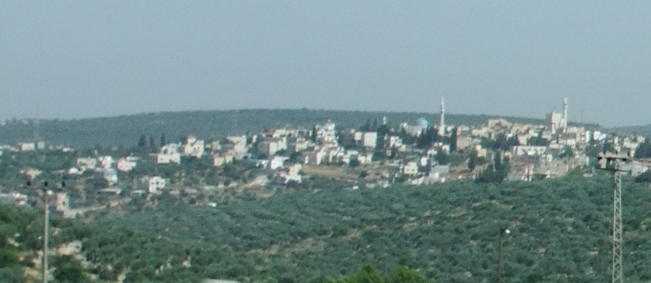
- Deir Istiya
-
Deir Istiya Other transcription(s) – Arabic دير إسيتا – Also spelled Deir Istya (official)
Dayr Istiya (unofficial)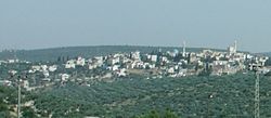 Location of Deir Istiya within the Palestinian territories
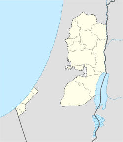
 Deir Istiya
Coordinates: 32°07′50.71″N 35°08′24.17″E / 32.1307528°N 35.1400472°ECoordinates: 32°07′50.71″N 35°08′24.17″E / 32.1307528°N 35.1400472°E Governorate Salfit Government – Type Village Council – Head of Municipality Jamal Diab[1] Area – Jurisdiction 24,000 dunams (24.0 km2 / 9.3 sq mi) Population (2007) – Jurisdiction 3,106 Name meaning "Monastery of Istiya" (probably Isaiah) Deir Istiya (Arabic: دير إسيتا) is a Palestinian town of 3,106 located in the Salfit Governorate in the northern West Bank, 15 kilometers (9.3 mi) southwest of Nablus and 7 kilometers (4.3 mi) east of Salfit. The built-up area of Deir Istiya is 74 dunams, and its old city has about thirty families.[2]
Contents
History
The town is named for the nearby tomb of Istiya which according to Tawfiq Canaan and Moshe Sharon is the alternated form of the Arabic name for Isaiah.[3] In 1394, Deir Istiya was required to supply lentils, olive oil and flour as a religious endowment (waqf) to the Ibrahimi Mosque in Hebron on the orders of the Mamluk sultan Barquq.[4]
Since the Mamluk-era of rule, Deir Istiya has been a center of olive-based agriculture. Today, it possesses one of the largest amount land used for olive groves, at nearly 10,000 dunams.[2] It was a part of Sanjak Nablus in Ottoman times. In the early 17th century, Deir Istiya was, along with Beit Wazan, the ancestral seat of the Qasim family who controlled Jamma'in and most of eastern Sanjak Nablus. The Qasim fortified and made Deir Istiya their primary southern base. The Rayyan clan from Majdal Yaba also exercised some control over the village.[5] During the "civil war" period in the Nablus area (1853-57), the Qasim family led by Qasim al-Ahmad vacated Deir Istiya and were said to have sought refuge with the Nimr family in Nablus.[6]
In the second half of the 19th century, however, the village was ruled by the Abu Hijleh clan, who continue to live there. The Abu Hijleh were dominant in the area, and had great wealth.[7] The Zidan family was also prominent and both families had shared control of Deir Istiya.[2]
In 1870, Victor Guerin remarked that Deir Istiya had been much larger and that it was probably inhabited since "ancient times", noting that in the Mosque of Deir Istiya were marble columns (some with chiseled out crucifixes) dating back to the Christian era in Palestine.[8]
Twentieth century
The British wrested control of Palestine from the Ottomans in 1917, and in 1921, a resident was publicly beat to death in Deir Istiya for allegedly possessing weapons. The British appointed the role of leadership to one branch of Abu Hijleh clan, fomenting rivalry with the other branch. The British established a school in the village in 1923, and during the years of British Mandate of Palestine, Deir Istiya was one of the main villages in the central-western Samaria.[9]
After the 1948 Arab-Israeli War, it was annexed by Jordan, and from 1950 to 1960, the Palestine Communist Party became prominent in the village earning it the local name of "Little Berlin". During the 1967 Six-Day War between Israel and coalition of Arab states, the village was targeted by Israeli forces. Most of the inhabitants were rounded up, with the women in the mosque and the men in the school, and the mayor Jamal Abu Hijleh was ordered to implement Israeli orders in the village.[9]
After its occupation by Israel, from 1960 to 1990, nearly half of the population emigrated to Kuwait or other Persian Gulf States. In the 1970s, local resistance in the form of sumud increased in the village, including the raising of Palestinian flags, graffiti, and blocking roads. As a result, in 1974, about 50 men were arrested and served prison terms ranging from six months to three years.[9]
Islamic structures
The Mosque of Deir Istiya located in the middle of the village. It consists of three aisles, each having three bays and nearby are the remains of an ancient wall. To the west of the village is the Mosque of Nabi Allah Amisiya, which consists of two aisles and two bays. The mosque is adjacent to Maqam Istiya. It is a square chamber with a dome constructed of small stones.[10] About 50 meters north of Deir Istiya is a shrine for Nabi Khatir who according to inscriptions, died in 1148 CE.[11]
Demographics
According to Victor Guerin in June 1870, Deir Istiya had roughly 400 inhabitants.[8] In the 1922 British survey, it had a population of 674 inhabitants , rising to 886 in a 1931 census.[12] Sami Hadawi recorded a population of 1,190 in 1945.[13] In 1961, while a part of Jordan,[12] there were 1,641 residents, decreasing drastically after its occupation by Israel with nearly half of the residents gradually emigrating mostly to Kuwait.[9] In 1982, there were 1,500 people living in Deir Istiya, rising to 2,100 in 1987.[12]
In a 1997 census carried out by the Palestinian Central Bureau of Statistics (PCBS), Deir Istiya had a population of 2,802, of which only 2.1% were Palestinian refugees.[14] Over half of the population is under the age of 20 (51.8%). People between the ages of 20 and 44 make up 33.3% of the population, 14.8% between 45 and 64, and 6% over the age of 65.[15] According to the PCBS 2007 Census, the town's population had increased to 3,106 [16]
There are primarily eighteen clans in the village. The Abu Hijleh, Salman, Mansour, and Diab families comprise three-fifths of the population. The Abu Hijleh own the most land in Deir Istiya, and hold lands in Biddya and Sanniriya, as well as some in Qalqilya and Nablus.[1]
Economy
Compared to other villages in the Salfit District, Deir Istiya has a high percentage of professional workers (doctors, office workers, lawyers). About 20% of the people work in government related jobs, with the Palestinian National Authority, mostly police or teachers. Between 1967 and 1993, most of the working inhabitants were employed mainly in farming or labor in Israel, which the village was highly dependent upon. However, after Israel closed the border in 2000 due to the Second Intifada, most of these laborers turned to farming their own fields.[1]
Deir Istiya has the largest land area in the Salfit Governorate, and the second largest in the West Bank after Tubas. Since the Intifada, agriculture — the backbone of the village's economy — has drastically been reduced. Prior to the violence, there were sixteen goat farms and nine dairy farms, decreasing to five goat farms and one dairy farm presently. Olive oil is the main commodity and there are vast amounts of olive trees. Most of the oil is either exported to the Gulf States or sold to Palestinian merchants.[1]
Prior to the Intifada, 40 families raised livestock, but this dramatically decreased to just five families after the Intifada. Residents claim that the decrease was due to Israel's confiscation of 20,000 dunams of village lands, and fear of attack by Israeli settlers. In 2008, over 70% of the village was unemployed. There are three oil presses and two marble processing plants in Deir Istiya. Marble is supplied by Hebron, Jenin or imported from Italy. About 15 women are employed in a sewing factory where pieces are received and assembled.[1]
Government
A village council of eleven members administrates Deir Istiya. The members are nominated by the prominent families of the village, and are approved by the Palestinian National Authority.[1] In the 2005 Palestinian municipal elections, Fatah won three seats, Hamas won three, the Communist Palestinian People's Party (PPP) won three, including the mayoral seat, and a local group won two seats.[17] PPP member Nafiz Mansour won the post of mayor.[2]
References
- ^ a b c d e f Deir Istiya Village Profile International Women's Peace Service. July 2008.
- ^ a b c d Focus of Cultural Heritage Programme of Assistance to the Palestinian People. pp.11-14.
- ^ Sharon, 1997, p.64
- ^ Sharon, 1997, pp.62-63.
- ^ Schölch, 1993, p.184.
- ^ Schölch (1993) p.215
- ^ Doumani, 1995, p.174.
- ^ a b Sharon, 1997, p.62
- ^ a b c d Deir Istya Village Profile International Women's Peace Service.
- ^ Sharon, 1997, p.65.
- ^ Sharon, 1997, p.68.
- ^ a b c Welcome to Dayt Istiya
- ^ Hadawi, 1970, p.59
- ^ Palestinian Population by Locality and Refugee Status Palestinian Central Bureau of Statistics (PCBS).
- ^ Palestinian Population by Locality, Sex and Age Groups in Years Palestinian Central Bureau of Statistics (PCBS).
- ^ Census Final Results – Summary (Population, Buildings, Housing, Establishments) Salfit Governorate
- ^ Local Elections (Round Three)- Successful lists by local authority and No. of votes obtained Central Elections Commission - Palestine, p.6.
Bibliography
- Guérin, M. V.: (1875): Description Géographique, Historique et Archéologique de la Palestine. Samarie, 2 pt. ("Seconde partie -Samarie")("Tome II") (p. 160)
- Hadawi, Sami (1970), Village Statistics of 1945: A Classification of Land and Area ownership in Palestine, Palestine Liberation Organization Research Center, http://www.palestineremembered.com/Articles/General-2/Story3150.html
- Doumani, Beshara (1995), Rediscovering Palestine: Merchants and Peasants in Jabal Nablus, 1700-1900, University of California Press, ISBN 9780520203709, http://books.google.com/?id=zry-tpH3rz8C&pg=PA174&dq=Dayr+Istya
- Sharon, Moshe (1997), Corpus Inscriptionum Arabicarum Palaestinae, BRILL, ISBN 9789004131972, http://books.google.com/?id=01ogNhTNz54C&pg=PA62&dq=Dayr+Istiya
- Schölch, Alexander (1993), Palestine in Transformation, 1856-1882: Studies in Social, Economic, and Political Development, Institute for Palestine Studies, ISBN 9780887282348, http://books.google.com/?id=cMVtAAAAMAAJ&q=Dayr+Istya&dq=Dayr+Istya
External links
Salfit Governorate Municipalities 

Villages Bruqin · Deir Ballut · Deir Istiya · Farkha · Haris · Iskaka · Kifl Hares · Marda · Mas-ha · Qarawat Bani Hassan · Qira · Rafat · Sarta · YasufCategories:- Salfit Governorate
- Villages in the West Bank

Wikimedia Foundation. 2010.