- 'Anata
-
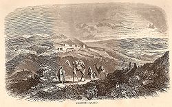
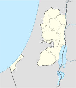
'Anata Other transcription(s) - Arabic عناتا - Also spelled Anata (official) 'Anata, around 1859[1] Location of 'Anata within the Palestinian territories Coordinates: 31°48′45.58″N 35°15′42.60″E / 31.8126611°N 35.261833°ECoordinates: 31°48′45.58″N 35°15′42.60″E / 31.8126611°N 35.261833°E Governorate Jerusalem Government - Type Village Council - Head of Municipality Mohammad Mahmoud al-Rifai Area - Jurisdiction 30,603 dunams (30.6 km2 / 11.8 sq mi) Population (2006) - Jurisdiction 9,600 'Anata (Arabic: عناتا) is a Palestinian town in the Jerusalem Governorate in the central West Bank, located four kilometers northeast of Jerusalem. According to the Palestinian Central Bureau of Statistics, 'Anata had a population of 9,600 in 2006.[2] Its total land area is 30,603 dunams, of which over half now lies within Jerusalem and 1,654 is Palestinian built-up area.[3]
Contents
History
Edward Robinson identified 'Anata with Biblical Anathoth, birthplace of Jeremiah, in his Biblical researches in Palestine.[4]
There are ruins of a Byzantine-era church in the town leading to the belief that it was inhabited prior to the Muslim conquest of Palestine by the Rashidun Caliphate.[5] During the Muslim siege of Jerusalem against the Crusaders, the Ayyubid general and sultan, Saladin situated his administration in 'Anata before he proceeded towards Jerusalem.
The village was destroyed by Ibrahim Pasha in 1832 following a pro-Ottoman Arab revolt against Egyptian rule.[3] When W. M. Thomson visited it in the 1850s, he described it as a "small, half-ruined hamlet, but it was once much larger, and appears to have had a wall around it, a few fragments of which are still to be seen."[6] It was rebuilt soon after and was settled by ten Arab families from Khirbet 'Almit, a mile to the northeast in the mid-19th century.[5] The families are Abd al-Latif, Ibrahim, Alayan, Hilwa, Salama, Hamdan, Abu Haniya Musah and al-Kiswani. The latter family fled to 'Anata during the 1948 Arab-Israeli War.[3]
Sanctuaries
'Anata contains two sanctuaries, dedicated to Saleh and possibly Jeremiah. The former is a mosque dedicated to the prophet Saleh (Biblical Shelah), but Saleh's tomb is believed to be in the village of Nabi Salih to the north. The latter sanctuary is a cave dedicated to a "Rumia" which according to Charles Simon Clermont-Ganneau, "looks as if it had been connected by the folklore with the name Jeremiah, the initial 'je' being removed by aphaeresis as so frequently happens in Arabic." This signifies that it is very possible that "Rumia" is an Arabicized form of "Jeremiah".[5]
Government
Before 1996, 'Anata was governed by a mukhtar. Since then a village council was established to govern the town. According to the village council of 'Anata, about 97% of its land outside of Jerusalem is under complete Israeli control. The boundaries of the village span about 30,603 dunams, although only 1654 dunams are designated as a built-up area, most of which is under the civil administration of the Palestinian National Authority and the security of Israel.[3] The village boundaries are far-reaching and stretch from 'Anata itself to just east of the Israeli settlement Alon. Most of the land is undeveloped open space with little or no vegetation.[7]
References
- ^ William McClure Thomson (1860): The Land and the Book: Or, Biblical Illustrations Drawn from the Manners and Customs, the Scenes and Scenery, of the Holy Land Vol II , p. 549
- ^ Projected Mid -Year Population for Jerusalem Governorate by Locality 2004- 2006 Palestinian Central Bureau of Statistics.
- ^ a b c d 'Anata Village Profile Applied Research Institute - Jerusalem. 21 July 2004.
- ^ Edward Robinson (1856): Biblical researches in Palestine, 1838-52. A journal of travels in the year 1838. By E. Robinson and E. Smith. Drawn up from the original diaries, with historical illustrations
- ^ a b c Sharon, Moshe. (1995). Corpus Inscriptionum Arabicarum Palaestinae BRILL, p.87.
- ^ William McClure Thomson (1860): The Land and the Book: Or, Biblical Illustrations Drawn from the Manners and Customs, the Scenes and Scenery, of the Holy Land Vol II , p. 548
- ^ Applied Research Institute of Jerusalem. Land Use/Land Cover Map of 'Anata Village Boundary (Map). http://www.poica.org/editor/case_studies/landuse-landcover%20anata-final.jpg.
Jerusalem Governorate Municipalities 

Villages 'Anata · 'Arab al-Jahalin · Beit 'Anan · Beit Duqqu · Beit Hanina · Beit Iksa · Beit Safafa · Beit Surik · Jaba' · al-Jib · al-Judeira · Kalandia · Mikhmas · Nabi Samwil · al-Qubeiba · Rafat, Jerusalem · as-Sawahira ash-Sharqiya · Sharafat · ash-Sheikh Sa'd ·
az-Za'ayyemRefugee camps Categories:- Jerusalem Governorate
- Villages in the West Bank
Wikimedia Foundation. 2010.


