- Dent, Cumbria
-
Coordinates: 54°16′34″N 2°27′07″W / 54.276°N 2.452°W
Dent 
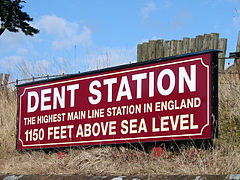
Dent Railway Station
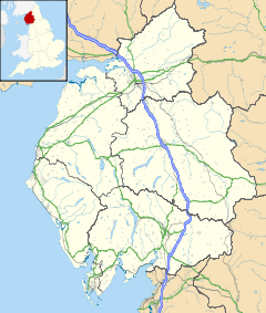
 Dent shown within Cumbria
Population 675 (2001) OS grid reference SD7087 Parish Dent District South Lakeland Shire county Cumbria Region North West Country England Sovereign state United Kingdom Post town SEDBERGH Postcode district LA10 Dialling code 015396 Police Cumbria Fire Cumbria Ambulance North West EU Parliament North West England UK Parliament Westmorland and Lonsdale List of places: UK • England • Cumbria Dent is a small village and civil parish in Cumbria, England, nestling in a narrow valley on the western slopes of the Pennines within the Yorkshire Dales National Park. It is about 4 miles (6.4 km) south east of Sedbergh and about 8 miles (13 km) north east of Kirkby Lonsdale.
Historically a part of the West Riding of Yorkshire, Dent lies in the valley of Dentdale, but the river is the River Dee, a tributary of the River Lune.
Both place name and dialect evidence indicate that this area was settled by Irish-Norse invaders in the 10th century (Hedevind 1967). Geoffrey Hodgson, in 2008, argued that this invasion accounts for the high frequency of the Hodgson surname in the area.
Dentdale was one of the last Yorkshire Dales to be enclosed, Dent's Enclosure Award being made in 1859.[1]
The Dent Brewery is an independent microbrewery in Cowgill, just above Dent.
Dent was the original site of the Dent Folk Festival and is now the site of the Dent Music and Beer Festival at the end of June (see website: dentmusicandbeer.com) The first event was held in 2009 and was hailed as a great success[2]
Dent was also the birthplace of the geologist, Adam Sedgwick.
The Folk song 'The Jolly Miller of Dee' is popular in Dentdale and is thought by some local historians to have been inspired by the ancient watermill at Rash Bridge near the mouth of the River Dee.
Whilst fishing on the Dee at Dentdale in the 1840s, William Armstrong, 1st Baron Armstrong saw a waterwheel in action, supplying power to a marble quarry. It struck Armstrong that much of the available power was being wasted and it inspired him to design a successful hydraulic engine which began the accumulation of his wealth and industrial empire.
Dent railway station on the Settle and Carlisle Railway is about 4 miles (6.4 km) above the village at Denthead. Nearby, the railway goes over a viaduct.
Contents
See also
Notes
- Hedevind, Bertil (1967) The Dialect of Dentdale in the West Riding of Yorkshire (Uppsala: Acta Universitatis Upsaliensis).
- Hodgson, Geoffrey M. (2008) Hodgson Saga, second edition (Standon, Hertfordshire: Martlet Books).
References
- ^ Roads and Trackways of the Yorkshire Dales, Geoffrey N. Wright, ISBN 0 86190 4109
- ^ http://www.dentmusicandbeer.com/#thankyou
External links
Ceremonial county of Cumbria Cumbria Portal Boroughs or districts City of Carlisle • Borough of Allerdale • Borough of Barrow-in-Furness • Borough of Copeland • District of Eden • District of South LakelandMajor settlements Alston • Ambleside • Appleby-in-Westmorland • Aspatria • Barrow-in-Furness • Bowness-on-Windermere • Brampton • Broughton-in-Furness • Carlisle • Cleator Moor • Cockermouth • Dalton-in-Furness • Egremont • Grange-over-Sands • Harrington • Kendal • Keswick • Kirkby Lonsdale • Kirkby Stephen • Longtown • Maryport • Millom • Penrith • Sedbergh • Silloth • Ulverston • Whitehaven • Wigton • Windermere • Workington
See also: List of civil parishes in CumbriaTopics Demography • Economy • Education • Geography • History • People • Places of interest • Settlements • Sport • Symbols and county emblems • TransportCategories:- Villages in Cumbria
- Civil parishes in Cumbria
Wikimedia Foundation. 2010.

