- Mount Alto, West Virginia
-
This article is about a community in West Virginia. For the mountain in Kilkenny, Ireland, see Mount Alto, Kilkenny.
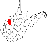
Mount Alto — Unincorporated community — Location within the state of West Virginia Coordinates: 38°51′52″N 81°52′41″W / 38.86444°N 81.87806°WCoordinates: 38°51′52″N 81°52′41″W / 38.86444°N 81.87806°W Country United States State West Virginia County Jackson Time zone Eastern (EST) (UTC-5) - Summer (DST) EDT (UTC-4) ZIP codes 25264[1] FIPS code GNIS feature ID Mount Alto is an unincorporated community in far western Jackson County, West Virginia, USA. It lies along West Virginia Route 331 northwest of the city of Ripley, the county seat of Jackson County.[2] Its elevation is 709 feet (216 m).[3] Mount Alto had a post office, which closed on June 20, 2009.[4]
United States Senator Carte Goodwin is a native of Mount Alto.
References
- ^ United States Postal Service (2010). "USPS - ZIP Code Lookup - Search By Address". http://zip4.usps.com/zip4/welcome.jsp. Retrieved 2010-07-07.
- ^ DeLorme. West Virginia Atlas & Gazetteer. 4th ed. Yarmouth: DeLorme, 2007, p. 32-33. ISBN 0-89933-327-3.
- ^ U.S. Geological Survey Geographic Names Information System: Mount Alto, West Virginia, Geographic Names Information System, 1980-06-27. Accessed 2008-05-31.
- ^ "Postmaster Finder - Post Offices by ZIP Code". United States Postal Service. http://webpmt.usps.gov/pmt008.cfm. Retrieved October 10, 2011.
Municipalities and communities of Jackson County, West Virginia County seat: Ripley Cities Unincorporated
communitiesAdvent | Cottageville | Duncan | Evans | Fairplain | Flatwoods | Gay | Given | Goldtown | Independence | Kenna | Kentuck | LeRoy | Liverpool‡ | Millwood | Mt. Alto | Murraysville | Rock Castle | Romance | Sandyville | Sherman | Silverton | Statts Mills
Footnotes ‡This populated place also has portions in an adjacent county or counties
Categories:- Populated places in Jackson County, West Virginia
- Unincorporated communities in West Virginia
- Mid-Ohio Valley geography stubs
Wikimedia Foundation. 2010.


