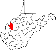
- Duncan, West Virginia
-
Duncan, West Virginia — Unincorporated community — Coordinates: 38°54′10″N 81°34′24″W / 38.90278°N 81.57333°WCoordinates: 38°54′10″N 81°34′24″W / 38.90278°N 81.57333°W Country United States State West Virginia County Jackson Elevation 630 ft (192 m) Time zone Eastern (EST) (UTC-5) – Summer (DST) EDT (UTC-4) Area code(s) 304 & 681 GNIS feature ID 1549662[1] Duncan is an unincorporated community in Jackson County, West Virginia, United States. Duncan is located on the Right Fork Sandy Creek and County Route 13 8 miles (13 km) west of Reedy.[2] Duncan had a post office, which opened on February 10, 1892, and closed on July 1, 1989.[3]
References
- ^ U.S. Geological Survey Geographic Names Information System: Duncan, West Virginia
- ^ West Virginia Department of Transportation (2011). Jackson County, West Virginia General Highway Map (Map). p. 2. http://gis.wvdot.com/gti/County_Maps/Jackson_2_of_3.pdf. Retrieved October 12, 2011.
- ^ "Postmaster Finder - Post Offices by ZIP Code". United States Postal Service. http://webpmt.usps.gov/pmt008.cfm. Retrieved October 12, 2011.
Municipalities and communities of Jackson County, West Virginia Cities Unincorporated
communitiesAdvent | Cottageville | Duncan | Evans | Fairplain | Flatwoods | Gay | Given | Goldtown | Independence | Kenna | Kentuck | LeRoy | Liverpool‡ | Millwood | Mt. Alto | Murraysville | Rock Castle | Romance | Sandyville | Sherman | Silverton | Statts Mills
Footnotes ‡This populated place also has portions in an adjacent county or counties
Categories:- Populated places in Jackson County, West Virginia
- Unincorporated communities in West Virginia
- Mid-Ohio Valley geography stubs
Wikimedia Foundation. 2010.


