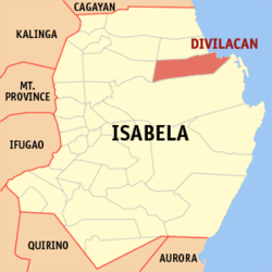
- Divilacan, Isabela
-
Divilacan — Municipality — Map of Isabela showing the location of Divilacan. Location in the Philippines Coordinates: 17°20′N 122°18′E / 17.333°N 122.3°ECoordinates: 17°20′N 122°18′E / 17.333°N 122.3°E Country  Philippines
Region Cagayan Valley (Region II) Province Isabela District 1st District, Isabela Founded Barangays 12 Government – Mayor Venturito C. Bulan Area – Total 889.49 km2 (343.4 sq mi) Population (2007) – Total 4,602 – Density 5.2/km2 (13.4/sq mi) Time zone PST (UTC+8) ZIP code 3335 Income class 3rd class; rural Population Census of Divilacan Census Pop. Rate 1995 2,593 — 2000 3,413 6.07% 2007 4,602 4.21% Divilacan is a 3rd class municipality in the province of Isabela, Philippines. According to the latest census, it has a population of 4,602 people in 633 households.
Barangays
Divilacan is politically subdivided into 12 barangays.
- Dicambangan
- Dicaruyan
- Dicatian
- Bicobian
- Dilakit
- Dimapnat
- Dimapula (Pob.)
- Dimasalansan
- Dipudo
- Dibulos
- Ditarum
- Sapinit
External links
- Philippine Standard Geographic Code
- 1995 Philippine Census Information
- 2000 Philippine Census Information
- 2007 Philippine Census Information
Municipalities - Alicia
- Angadanan
- Aurora
- Benito Soliven
- Burgos
- Cabagan
- Cabatuan
- Cordon
- Delfin Albano
- Dinapigue
- Divilacan
- Echague
- Gamu
- Ilagan
- Jones
- Luna
- Maconacon
- Mallig
- Naguilian
- Palanan
- Quezon
- Quirino
- Ramon
- Reina Mercedes
- Roxas
- San Agustin
- San Guillermo
- San Isidro
- San Manuel
- San Mariano
- San Mateo
- San Pablo
- Santa Maria
- Santo Tomas
- Tumauini
Component city - Cauayan
Independent component city - Santiago
Categories:- Municipalities of Isabela
Wikimedia Foundation. 2010.


