- South Marsh Mill, Arundel
-
Arundel Windmill 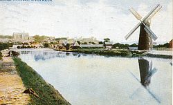
The mill c1920Origin Mill name South Marsh Mill Mill location TQ 013 063
50°50′49″N 0°33′43″W / 50.847°N 0.562°WOperator(s) Private Year built 1830 Information Purpose Corn mill Type Tower mill Storeys Five storeys Number of sails Four sails Type of sails Patent sails Windshaft Cast iron Winding Fantail Auxiliary power Engine South Marsh Mill is a grade II listed[1] tower mill at Arundel, Sussex, England which has been converted to residential use.
Contents
History
South Marsh Mill was built in 1830. It was working by wind until 1915, when the windshaft snapped, but was worked by engine until 1922. The machinery was removed c.1941.[2]
Description
For an explanation of the various pieces of machinery, see Mill machinery.South Marsh Mill is a five storey tower mill. She had four Patent sails carried on a cast iron windshaft. The cap was a beehive shape, winded by a fantail. The mill drove three pairs of millstones. The cap now carried is an octagonal shape, housing the broken windshaft. The fantail is missing.[2] Various extensions have been made to the tower.[1]
Millers
- Messrs Dendy & Pellet 1830 - 1840
- Henry Bartlett 1840 -
- William Watkins 1840 -
References for above:-[2]
See also
- Wikipedia books: Windmills in Sussex
References
- ^ a b "WINDMILL, FITZALAN ROAD (west side), ARUNDEL, ARUN, WEST SUSSEX". English Heritage. http://www.imagesofengland.org.uk/details/default.aspx?pid=2&id=297163. Retrieved 2008-05-12.
- ^ a b c Brunnarius, Martin (1979). The Windmills of Sussex. Chichester: Philimore. pp. p65–66, 190. ISBN 0 85033 345 8.
External links
- Windmill World Page on South Marsh windmill.
Further reading
Hemming, Peter (1936). Windmills in Sussex. London: C W Daniel. Online version
Categories:- Tower mills
- Grinding mills
- Buildings and structures completed in 1830
- Grade II listed buildings in West Sussex
- Windmills in West Sussex

Wikimedia Foundation. 2010.