- Devils Marbles Conservation Reserve
-
Devils Marbles Conservation Reserve IUCN Category V (Protected Landscape/Seascape)
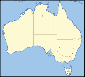
Nearest town/city Wauchope Coordinates 20°34′S 134°16′E / 20.567°S 134.267°ECoordinates: 20°34′S 134°16′E / 20.567°S 134.267°E Area 18.02 km² Established October 1961[1] Managing authorities Parks and Wildlife Commission of the Northern Territory Official site Devils Marbles Conservation Reserve The Devils Marbles Conservation Reserve is located south of Tennant Creek area of Northern Territory in Australia.
Contents
Location
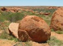
The area is located near Wauchope, approximately 114 km south of Tennant Creek, in the Northern Territory. The site is known as Karlu Karlu to the land's Aboriginal traditional owners. The ‘Devils Marbles’ or ‘Karlu Karlu’ with its gigantic, rounded granite boulders, some spectacularly poised, is a remarkable landscape. Scattered clusters of these ‘marbles’, including many balancing rocks, are spread across a wide, shallow valley. The Devils Marbles is a nationally and internationally recognised symbol of Australia’s outback.
In 2007, according to the Northern Territory Natural Resources, Environment, The Arts and Sport 96,172 people visited the reserve[2]. It is one of the most visited of any park or reserve in the Northern Territory and one of the main tourist attractions in the Barkly region.
The Reserve is accessible all year round and has a network of pathways with information boards and a basic camping area. Between May and October each year Rangers offer a program of live events at the site as part of their Territory Parks Alive Program.
Accounts of Aborigines believing the site to be eggs of the mythical Rainbow Serpent are incorrect. In reality many diverse traditional 'Dreaming' stories (none of which are about serpents) intersect at and around Karlu Karlu, hence its great importance as a sacred site. These stories are alive and well and are passed on from generation to generation of Traditional Owners. Only a handful are considered suitable to tell to uninitiated visitors.
On Tuesday 28 October 2008 ownership of Karlu Karlu/Devils Marbles was officially passed from the Parks and Wildlife Service of the Northern Territory back to the Traditional Owners at a ceremony held on the reserve. The reserve is now leased back to the Parks Service under a 99 year lease and the site is now managed by Rangers and Traditional Owners in joint partnership. Visitor access has not been affected.
Formation
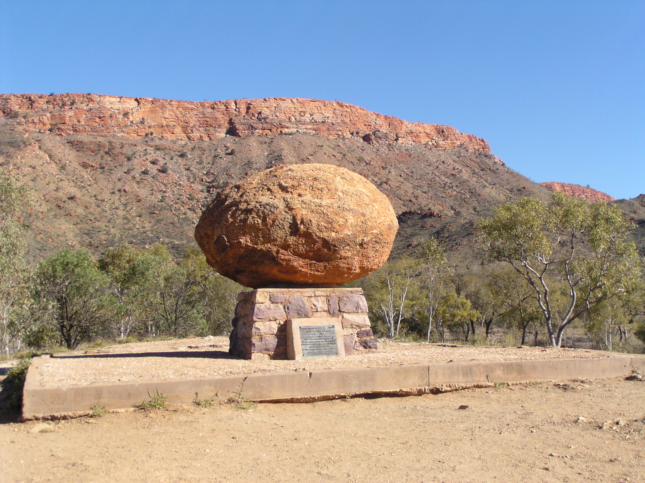
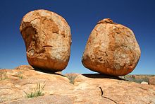 One of the boulder formations at the Devils Marbles Conservation Reserve, called Karlu Karlu by the Kaytetye.
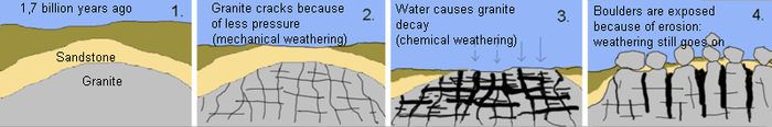
The Devils Marbles are made of granite, which surfaces like a little geological island in the desert, surrounded by large amounts of sandstone. The granite was formed millions of years ago as a result of the hardening of magma within the Earth's crust. Thick layers of sandstone on top of it put a lot of pressure on this granite. After the folding of the Earth's crust, which lead to the lifting of the granite and the erosion of the sandstone, the granite came to the surface. The pressure was gone, letting the granite expand; cracks formed, and it fell apart in big, square blocks.
 Solarisation splits the rocks in half
The second phase of the formation of the Marbles started when the blocks were exposed to water. The surface of the blocks began to decay under the influence of the water, and a layer of loose material surrounded the individual blocks. When they came to the surface completely, this layer was flushed away by water and blown away by wind.
The rounding of the granite blocks is a result of both chemical and mechanical weathering. Firstly, exfoliation plays a part. Chemical processes cause the surface of the blocks to expand and/or shrink. Thin layers of rock come off the boulder. This rounds the granite block, because the chemical processes have more effect on areas with edges. These processes cause the rock to look like it is made of layers like an onion. In effect, only the outer few centimetres are affected by chemical weathering. This process is called spheroidal weathering. Secondly, the boulders are suffering from solarisation. Because the temperature differences between day and night are so great, the rocks expand and shrink a little bit every 24 hours. This causes some rocks to crack, sometimes even splitting them in half.
Controversy
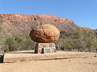 John Flynn's Memorial with the replaced boulder, Alice Springs
One of the marbles was removed from a formation in 1953 and taken to Alice Springs to form a permanent memorial to John Flynn, the founder of the Royal Flying Doctor Service in Australia. At the time, this was seen as a way of remembering his link to the outback, but in later decades it was a source of great controversy because the rock was removed from a sacred site without the direct permission of the tribal elders. In the late 1990s, a boulder swap was arranged, and the missing marble was removed from the grave, cleaned, and returned to its original place. The grave is now marked with a similar boulder donated by the local Arrernte people.[3]
References
- ^ "Place Names Register Extract". Northern Territory Land Information System. Northern Territory Government. http://www.ntlis.nt.gov.au/placenames/view.jsp?id=23548. Retrieved 3 June 2011.
- ^ "Devil’s Marbles Conservation Reserve Joint Management Plan". Northern Territory Natural Resources, Environment, The Arts and Sport. http://www.nt.gov.au/nreta/parks/manage/plans/pdf/devils_marbles_JMplan_feb09_managingvisitor.pdf.
- ^ John Flynn Memorial Story
External links
- "Controversy about removing a "marble"". Alice Springs News. 1999-09-08. http://www.alicespringsnews.com.au/0632.html.
- "Devils Marbles Conservation Reserve". http://www.nt.gov.au/nreta/parks/find/devilsmarbles.html.
- "Devil's Marbles handover ceremony". http://www.nt.gov.au:8080/nreta/parks/manage/joint/news/rainbow.html.
Categories:- IUCN Category V
- Protected areas of the Northern Territory
- Visitor attractions in the Northern Territory
- Rock formations in Australia
- Sacred rocks


Wikimedia Foundation. 2010.