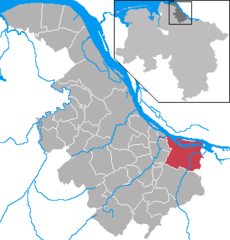
- Jork
-
Jork 
Coordinates 53°32′4″N 9°40′54″E / 53.53444°N 9.68167°ECoordinates: 53°32′4″N 9°40′54″E / 53.53444°N 9.68167°E Administration Country Germany State Lower Saxony District Stade Town subdivisions 7 districts Mayor Rolf Lühmann (CDU) Basic statistics Area 62.27 km2 (24.04 sq mi) Elevation 4 m (13 ft) Population 11,758 (31 December 2010)[1] - Density 189 /km2 (489 /sq mi) Other information Time zone CET/CEST (UTC+1/+2) Licence plate STD Postal code 21635 Area code 04162 Website www.jork.de Jork is a small town on the left bank of the Elbe, near Hamburg (Germany).
Jork belongs to the district of Stade, in Lower Saxony. The town is the capital of the Altes Land, one of the biggest fruit growing areas in Europe, and Jork is home to a Fruit Research Center.[2][3]
Contents
History
Jork was mentioned for the first time in a deed in 1221, then it belonged to the Prince-Archbishopric of Bremen in secular respect. As to religion Jork belonged to the Diocese of Verden (till 1648). In 1648 the Prince-Archbishopric was transformed into the Duchy of Bremen, which was first ruled in personal union by the Swedish and from 1715 on by the British and Hanoverian Crown. In 1807 the ephemeric Kingdom of Westphalia annexed the Duchy, before France annexed it in 1810. In 1813 the Duchy was restored to the Electorate of Hanover, which - after its upgrade to the Kingdom of Hanover in 1814 - incorporated the Duchy in a real union and the ducal territory, including Jork, became part of the Stade Region, established in 1823. From 1885 to 1932 Jork served as the capital of the Prussian District of Jork, comprising Altes Land, the city of Buxtehude and its today component Neuland, then still an independent municipality. The former district forms since a part of today's District of Stade.
-
Launch "Nordsee VII" passing the swing bridge at Jork-Estebrügge
Division of the town
Jork consists of 7 districts
- Borstel
- Estebrügge
- Hove
- Jork
- Königreich
- Ladekop
- Moorende
References
- ^ "Bevölkerungsfortschreibung" (in German). Landesbetrieb für Statistik und Kommunikationstechnologie Niedersachsen. 31 December 2009. http://www1.nls.niedersachsen.de/statistik/html/parametereingabe.asp?DT=K1000014&CM=Bev%F6lkerungsfortschreibung.
- ^ R. Stehr: Screening of sweet cherry cultivars in northern Germany, International Society for Horticultural Science
- ^ Seed and Plant Genetic Resources Service - AGPS,
External links
- Official site (German)
Agathenburg | Ahlerstedt | Apensen | Balje | Bargstedt | Beckdorf | Bliedersdorf | Brest | Burweg | Buxtehude | Deinste | Dollern | Drochtersen | Düdenbüttel | Engelschoff | Estorf | Fredenbeck | Freiburg | Großenwörden | Grünendeich | Guderhandviertel | Hammah | Harsefeld | Heinbockel | Himmelpforten | Hollern-Twielenfleth | Horneburg | Jork | Kranenburg | Krummendeich | Kutenholz | Mittelnkirchen | Neuenkirchen | Nottensdorf | Oederquart | Oldendorf | Sauensiek | Stade | Steinkirchen | WischhafenCategories:- Towns in Lower Saxony
- Lüneburg region geography stubs
Wikimedia Foundation. 2010.


