- Oederquart
-
Oederquart 

 OederquartLocation of Oederquart within Stade district
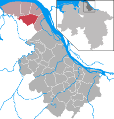
Coordinates 53.7895°N 9.2793°E / 53.7895°N 9.2793°ECoordinates: 53.7895°N 9.2793°E / 53.7895°N 9.2793°E Administration Country Germany State Lower Saxony District Stade Municipal assoc. Nordkehdingen Mayor Hans-Heinrich Janßen Basic statistics Area 37.1 km2 (14.3 sq mi) Elevation 0 m (0 ft) Population 1,138 (31 December 2010)[1] - Density 31 /km2 (79 /sq mi) Other information Time zone CET/CEST (UTC+1/+2) Licence plate STD Postal code 21734 Area code 04779 Website www.oederquart.de Oederquart is a municipality in the district of Stade, Lower Saxony, Germany.
It belonged to the Prince-Archbishopric of Bremen. In 1648 the Prince-Archbishopric was transformed into the Duchy of Bremen, which was first ruled in personal union by the Swedish and from 1715 on by the Hanoverian Crown. In 1823 the Duchy was abolished and its territory became part of the Stade Region.
Agathenburg | Ahlerstedt | Apensen | Balje | Bargstedt | Beckdorf | Bliedersdorf | Brest | Burweg | Buxtehude | Deinste | Dollern | Drochtersen | Düdenbüttel | Engelschoff | Estorf | Fredenbeck | Freiburg | Großenwörden | Grünendeich | Guderhandviertel | Hammah | Harsefeld | Heinbockel | Himmelpforten | Hollern-Twielenfleth | Horneburg | Jork | Kranenburg | Krummendeich | Kutenholz | Mittelnkirchen | Neuenkirchen | Nottensdorf | Oederquart | Oldendorf | Sauensiek | Stade | Steinkirchen | Wischhafen
References
- ^ "Bevölkerungsfortschreibung" (in German). Landesbetrieb für Statistik und Kommunikationstechnologie Niedersachsen. 31 December 2009. http://www1.nls.niedersachsen.de/statistik/html/parametereingabe.asp?DT=K1000014&CM=Bev%F6lkerungsfortschreibung.
Categories:- Municipalities in Lower Saxony
- Lüneburg region geography stubs


Wikimedia Foundation. 2010.