- Qift
-
Qift Location in Egypt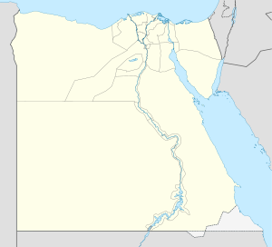
 Qift
QiftCoordinates: 25°59′44″N 32°48′57″E / 25.99556°N 32.81583°E Country  Egypt
EgyptGovernorate Qena Governorate Time zone EST (UTC+2) – Summer (DST) +3 (UTC)
Qift (Arabic: قفط; Coptic: Ⲕⲉϥⲧ Keft or Kebto; Egyptian Gebtu; Greek: Κόπτος Coptos or Koptos; Roman Justinianopolis) is a small town in the Qena Governorate of Egypt about 43 km north of Luxor, on the east bank of the Nile.Contents
History
In ancient Egypt, Qift, known then as Gebtu, was an important center for administration, religion, and commerce, being the chief city of the fifth Upper Egyptian Nome of Harawî (Two Hawks). From Qift and Qus, trading expeditions heading for the Red Sea and many mining expeditions into the Eastern Desert left the Nile Valley. Gebtu was at the starting-point of the two great caravan routes leading to the coast of the Red Sea, the one toward the port Tââou (Myoshormos), the other more southerly, toward the port of Shashirît (Berenice).
Under the native pharaohs, the whole trade of southern Egypt with the Red Sea passed over these two roads; under the Ptolemies as well as in Roman and Byzantine times, merchants followed the same roads for purposes of barter at the coasts of Zanzibar and in Southern Arabia, India, and the Far East.
 Min-Amen-ka-Mut-ef, Gebtu male fertility deity - Louvre
Gebtu was the most important religious center in the area. Its principal male deity was Min, a sky-god whose symbol was a thunderbolt. [1] He became a male fertility deity, [2], and also was regarded as the male deity of the desert region to the east.
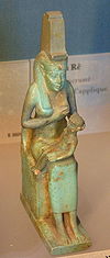 Isis nursing her infant son - Louvre
His cult rose to prominence in the Middle Kingdom. At that time, he became associated with Horus as the deity, Min-Horus. Later, he was fused with Amen in the deity Min-Amen-ka-Mut-ef, as "Min-Amen-bull of his mother" (Hathor-Isis).
Isis (Hathor-Isis) and her infant, Horus, were the deities connected with Gebtu, named Coptos during the Greco-Roman period, probably due to the reinterpretation of the Two Hawks of the Nome, Harawî, standard as Min and Horus.
Gebtu, once politically important, especially under the eleventh dynasty, was overshadowed by Thebes. It recuperated its prominence under the Antonines; it was the base camp of Legio III Cyrenaica, or at least one of its subunits. It rebelled, but soon was captured in 292 by Diocletian after a long siege and almost destroyed, but soon recovered its former standing.
In the 6th century, Qift was called by the Roman name, Justinianopolis. This century is considered the end of the Classical Age in Europe where the Dark Ages followed.
The Christian see was suffragan of Ptolemais in Thebais Secunda. Five bishops are known (Lequien, II, 607): Theodorus, a partisan of Meletius; Phoebammon in 431; Sabinus in 451; Vincent, author of the "Canonical Solutions", preserved in an Arabic translation and highly esteemed by the Copts; Moyses, who wrote the panegyric of Vincent.
Under the Muslim caliphs and the sultans, Qift remained one of the chief cities of Upper Egypt. In 1176, its Christian inhabitants raised the standard of revolt against the Muslims, but were suppressed promptly by Al-Adil, brother of Saladin, who hanged nearly 3,000 Copts on the trees around the city. In the 13th century, there still were numerous monasteries around the city. Qift was ruined in the 16th century by the Ottomans.
Archaeology
Remains of three temple groups surrounded by an enclosure wall were located during the excavations of W. M. Flinders Petrie in 1893-1894, and later, by Raymond Weill and Adolphe Joseph Reinach in 1910-1911.
The undecorated northern temple of Min and Isis was the work of an official named Sennuu on behalf of Roman occupiers during the Ptolemaic kingdom, namely, Ptolemy II Philadelphus ruling from 281 BC to 246 BC.
This northern temple has some later additions by Ptolemy IV Philopator ruling from 221-205 BC. He was the son of Ptolemy III and Berenice II of Egypt and was the fourth pharaoh of the Ptolemaic Egypt, when the decline of the Ptolemaic kingdom began. More additions were added by Julio-Claudian emperors of Rome, Caligula, and Nero.
This temple stands on the site of earlier Ancient Egyptian temple structures, those of the visor to Mentuhotep IV who became Amenemhat I and his son, Senusret I, both of the twelfth dynasty, and Thutmose III of the eighteenth dynasty. The remains of a chapel of Osiris, erected by Amasis II of the twenty-sixth, also were found near the northern temple.
At the site of the later middle temple built by Romans during the Ptolemaic kingdom, blocks of an earlier structure by Senusret I and a gate of Thutmose III, with additions probably made by Osorkon II of the twenty-second dynasty, were found. This later middle temple was built during the Ptolemaic kingdom by Ptolemy II Philadelphus, with minor additions by members of the Julio-Claudian dynasty of Rome, Caligula, Claudius, and Trajan.
At the site of the southern temple, are the gates of Nectanebo II of the thirtieth dynasty, who was the last native king of Egypt. He was placed on the throne by a Spartan king and lost a conflict with the Persians, who then overtook Egypt.
Other structures found at the site include a set of stelae, now known as the Koptos Decrees. These stelae date to the Sixth and Seventh Dynasties, with copies of royal decrees from the pharaohs concerning the temple and its personnel. The name by which the stelae are known reflects the much later Greek name for the city, Coptos or Koptos however.
A chapel of Ptolemaic dynasty pharaoh Cleopatra VII and her son, Ptolemy XV Caesarion, has been found at the site as well. These rulers of Ancient Egypt for six hundred years were not native, but of Greek origin. Without many changes, however, they adopted the culture and religious practices of the country they occupied. Cleopatra even learned the ancient Egyptian language, which never had been used by these rulers. The Greeks sought to find parallels to their own religious beliefs and would describe the Egyptian deities as related to their own.
Built even later, after the conquest by the Romans in 30 AD, gates associated with the Roman emperors Caligula and Claudius are documented at the site. The Romans also continued the religious traditions of Ancient Egypt, adopting some completely, and drawing parallels (similar to the Greek rulers) for others.
Northeast of Qift, at the modern village of El-Qala, the Roman emperor Claudius also built a small temple and dedicated it to Min, Isis, and Horus.
Qift was the focus of an American archaeological project from 1987 to 1992 and an Australian one between 2000 and 2003.
See also
External links
- Home Page, The Qift Regional Expedition, 31 July 2003, archived from the original on 9 April 2005, http://web.archive.org/web/20050409021924/http://www.koptos.com/index.htm, retrieved 28 June 2009
 This article incorporates text from a publication now in the public domain: Herbermann, Charles, ed (1913). Catholic Encyclopedia. Robert Appleton Company.
Ancient Egypt Outline · Index
Architecture · Art · Burial customs · Chronology · Cuisine · Dynasties · Geography · History · Literature · Mathematics · Medicine · Military · Music · Religion · Pharaohs (list) · People · Language · Sites · Technology · Writing
Egyptology · Egyptologists · Egyptian MuseumPortal · List of major topicsCoordinates: 25°59′44″N 32°48′57″E / 25.99556°N 32.81583°E
Categories:- Qena Governorate
- Ancient Greek sites in Egypt
- Roman sites in Egypt
- Roman legions' camps in Egypt
- Populated places in Egypt
- Former populated places in Egypt


Wikimedia Foundation. 2010.