- New York State Route 382
-
NYS Route 382
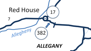
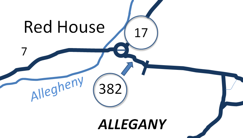
Map of the Red House area with NY 382 at centerRoute information Maintained by NYSDOT Length: 0.8 mi[5] (1.3 km) Existed: ca. 1932[1][2] – early 1970s[3][4] Major junctions West end:  NY 17 in Red House
East end: Allegany State Park entrance at Red House Location Counties: Cattaraugus Highway system Numbered highways in New York
Interstate • U.S. • N.Y. (former) • Reference • County←  NY 381
NY 383  →
→New York State Route 382 (NY 382) was a state highway in the town of Red House in Cattaraugus County, New York, United States. The highway was 0.8 miles (1.3 km) long and served as a connector between NY 17 and the Red House entrance of Allegany State Park, where it connected to Allegany State Park Route 2 (ASP Route 2). NY 382 was assigned in the early 1930s and removed in the early 1970s after the highway's connection to the park was dismantled as part of the Southern Tier Expressway's construction. The NY 382 designation is currently reserved by the New York State Department of Transportation as a replacement for NY 88 in Ontario County.
Contents
Route description
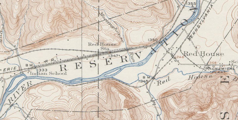
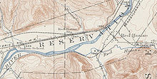 A 1923 United States Geological Survey topographic map of Red House. The east–west highway linking the hamlet of Red House to Allegany State Park was what became NY 382
The western terminus of NY 382 was at an intersection with NY 17 in the hamlet of Red House, located 5 miles (8.0 km) southwest of the city of Salamanca in the town of Red House. At the time, NY 17 was routed along an at-grade highway that paralleled the future routing of the Southern Tier Expressway to the north and west. NY 382 headed southeast from the junction, passing through the center of Red House before turning eastward ahead of Red House Brook, a small stream that branched off the nearby Allegheny River. NY 382 paralleled Red House Brook east to the Allegany State Park boundary, where the NY 382 designation ended and the highway continued east as Allegany State Park Route 2.[6][7][8]
History
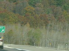 Exit 19 off-ramp. The construction of this exit resulted in the removal of the NY 382 designation
NY 382 was assigned ca. 1932 to a short roadway linking NY 17 to an entrance to Allegany State Park in Red House.[1][2] The route remained intact until the construction of the Southern Tier Expressway (STE) through Red House in the late 1960s and early 1970s. When exit 19 of the STE was constructed in 1970,[9] NY 382 was disconnected from Allegany State Park Route 2, which was realigned to meet the new exit.[10] The NY 382 designation was removed around this time as a result.[3][4] What remains of NY 382 is now a local access road for the Allegany Indian Reservation and the Allegheny Reservoir.[5]
The NY 382 designation is reserved by the New York State Department of Transportation for future use along what is now NY 88 in the Finger Lakes region of New York. Currently, NY 88 has the numerical designation as Interstate 88, an Interstate Highway in eastern New York.[11]
Major intersections
The entire route was in Red House, Cattaraugus County.
Mile[5] Destinations Notes 0.0 NY 170.8 Allegany State Park Continues as Allegany State Park Route 2 1.000 mi = 1.609 km; 1.000 km = 0.621 mi References
- ^ a b Kendall Refining Company (1931). New York (Map). Cartography by H.M. Gousha Company.
- ^ a b Texas Oil Company (1932). Texaco Road Map – New York (Map). Cartography by Rand McNally and Company.
- ^ a b State of New York Department of Transportation (January 1, 1970) (PDF). Official Description of Touring Routes in New York State. http://www.greaternyroads.info/pdfs/state70.pdf. Retrieved November 7, 2009.
- ^ a b Gulf (1974). New York and New Jersey Tourgide Map (Map). Cartography by Rand McNally and Company.
- ^ a b c Google, Inc. Google Maps – New York State Route 382 (Map). Cartography by Google, Inc. http://maps.google.com/maps?f=d&saddr=42.112797,+-78.801435&daddr=42.108490,+-78.787530&sll=42.110648,-78.794482&sspn=0.005452,0.014334&ie=UTF8&z=17. Retrieved April 24, 2008.
- ^ Pennsylvania Department of Highways (1960). Official Map of Pennsylvania (Map). ftp://ftp.dot.state.pa.us/public/pdf/BPR_pdf_files/Maps/Statewide/Historic_OTMs/1960fr.pdf. Retrieved November 7, 2009.
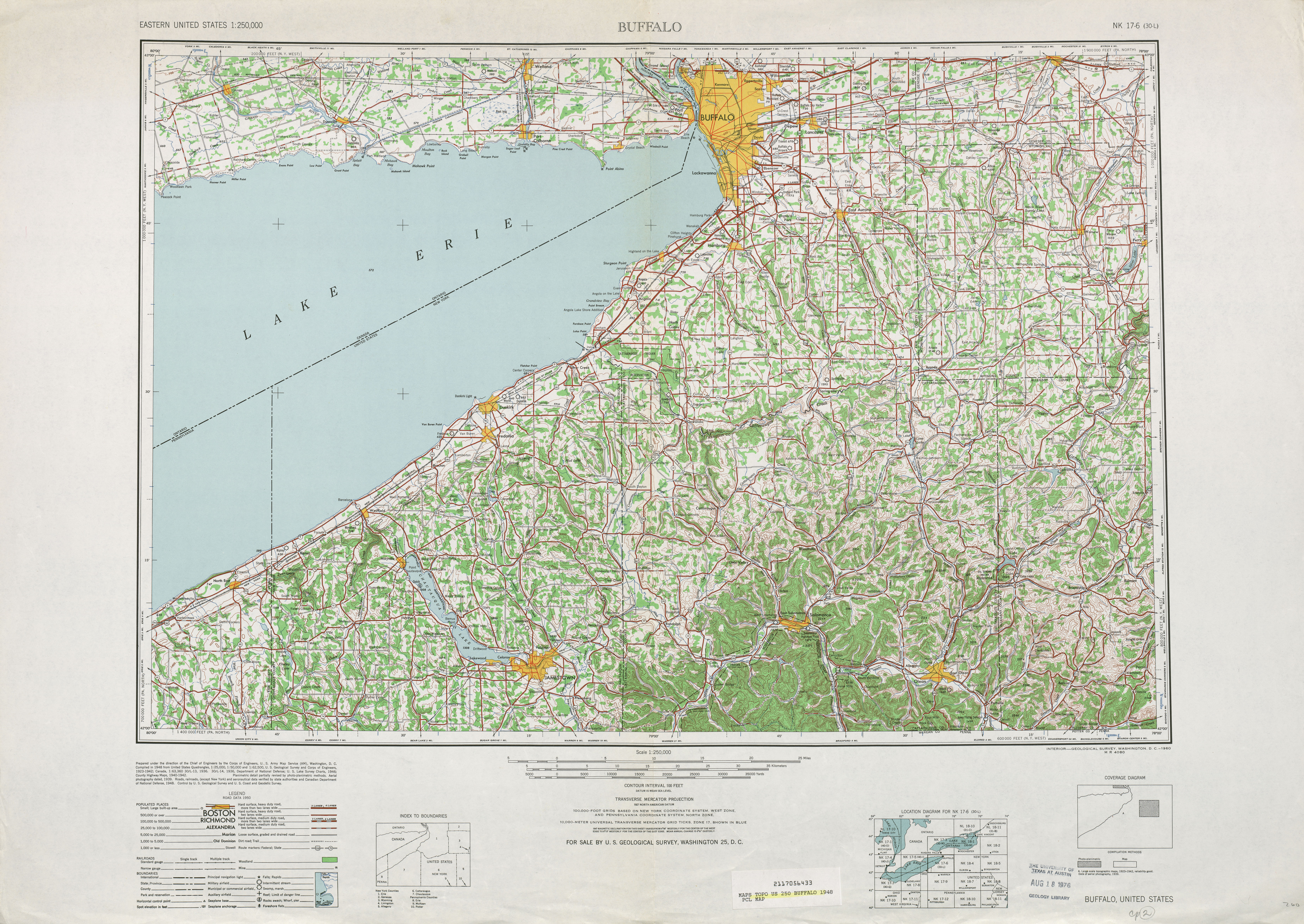
- ^ United States Geological Survey (1948). Buffalo, United States Topographic Map (Map). 1:250,000. Eastern United States 1:250,000. Section 42°00'N 78°45'W. http://www.lib.utexas.edu/maps/topo/250k/txu-pclmaps-topo-us-buffalo-1948.jpg. Retrieved April 10, 2008.
- ^ Yahoo! Inc. Yahoo! Maps – overview map of Allegany State Park Route 2 (Map). Cartography by NAVTEQ. http://maps.yahoo.com/#mvt=m&lat=42.017013&lon=-78.720619&zoom=13&q1=42.108263%2C-78.777611&q2=42.003238%2C-78.720276. Retrieved January 6, 2009.
- ^ Federal Highway Administration (2008). "Structure 1062791". National Bridge Inventory. United States Department of Transportation. http://nationalbridges.com/nbi_record.php?StateCode=36&struct=000000001062791. Retrieved January 3, 2010.
- ^ United States Geological Survey (1980). Red House Quadrangle – New York (Map). 1:24,000. 7.5 Minute Series (Topographic). http://www.nysgis.state.ny.us/gisdata/quads/drg24/usgspreview/index.cfm?code=o42078a7. Retrieved November 7, 2009.
- ^ New York State Department of Transportation (January 2009) (PDF). Official Description of Highway Touring Routes, Bicycling Touring Routes, Scenic Byways, & Commemorative/Memorial Designations in New York State. https://www.nysdot.gov/divisions/operating/oom/transportation-systems/repository/2009%20tour-bk.pdf. Retrieved November 7, 2009.
External links
Categories:- Former state highways in New York
- Transportation in Cattaraugus County, New York


Wikimedia Foundation. 2010.