- Mynydd-Bach
-
For the village in Monmouthshire, see Shirenewton.
Coordinates: 51°39′32″N 3°56′58″W / 51.65889°N 3.94951°W
Mynydd-Bach 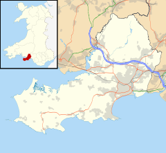
 Mynydd-Bach
Mynydd-Bach shown within SwanseaOS grid reference SS652973 Principal area Swansea Ceremonial county West Glamorgan Country Wales Sovereign state United Kingdom Post town SWANSEA Postcode district SA5 Dialling code 01792 Police South Wales Fire Mid and West Wales Ambulance Welsh EU Parliament Wales UK Parliament Swansea East Welsh Assembly Swansea East List of places: UK • Wales • Swansea Mynydd-Bach is a suburban district of the City and County of Swansea, Wales and falls within the Mynydd-Bach ward. Mynydd-Bach is located about 2.5 miles (4.0 km) north of Swansea city centre.
Bishop Vaughan Catholic Comprehensive School and Daniel James Community School are located in Mynydd-Bach.
Park View Estate
Park View Estate, also known as the Simcox Estate, is an area between Treboeth and Morriston in the Mynydd-Bach ward. It was built in the late 1960s to the early 1970s.
Although Park View Estate is not part of Morriston and is at least one mile (1.6 km) away, people who live in the area are home addressed as Morriston. The area itself is about three miles (5 km) away from Swansea city centre.
Surrounding the area are common fields that are usually used for people who keep horses, a park named Llewellyn Park and an old work house called Morris Castle which was built in the 18th century.
Categories:- Swansea geography stubs
- Districts of Swansea

Wikimedia Foundation. 2010.