- Bristol, Vermont
Infobox Settlement
official_name = Bristol, Vermont
settlement_type = Town
nickname =
motto =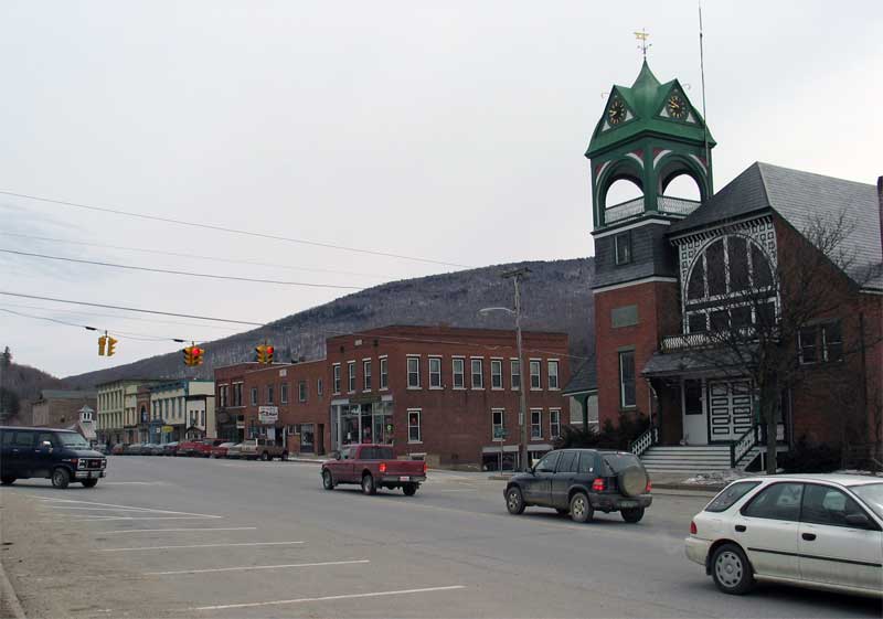
imagesize = 250px
image_caption = Main Street in Bristol
image_
mapsize = 250px
map_caption = Bristol, Vermont
mapsize1 =
map_caption1 =subdivision_type = Country
subdivision_name =United States
subdivision_type1 = State
subdivision_name1 =Vermont
subdivision_type2 = County
subdivision_name2 = Addisongovernment_footnotes =
government_type =
leader_title =
leader_name =
leader_title1 =
leader_name1 =
established_title = Chartered
established_date = 1762
established_title2 = Settled
established_date2 = 1783
established_title3 = Organized
established_date3 = 1789unit_pref = Imperial
area_footnotes =area_magnitude =
area_total_km2 = 109.2
area_land_km2 = 108.2
area_water_km2 = 1.0
area_total_sq_mi = 42.2
area_land_sq_mi = 41.8
area_water_sq_mi = 0.4population_as_of = 2000
population_footnotes =
population_total = 3788
population_density_km2 = 35.0
population_density_sq_mi = 90.7timezone = Eastern (EST)
utc_offset = -5
timezone_DST = EDT
utc_offset_DST = -4
elevation_footnotes =
elevation_m = 159
elevation_ft = 522
latd = 44 |latm = 8 |lats = 0 |latNS = N
longd = 73 |longm = 4 |longs = 46 |longEW = Wpostal_code_type =
ZIP code
postal_code = 05443
area_code = 802
blank_name = FIPS code
blank_info = 50-09025GR|2
blank1_name = GNIS feature ID
blank1_info = 1462053GR|3
website =
footnotes =Bristol is a town in Addison County,
Vermont ,United States . The town was foundedJune 26 ,1762 . The population was 3,788 at the 2000 census. Main Street is home to most of the businesses of the town. The town is also home to theLord's Prayer Rock.cite web|url = http://www.roadsideamerica.com/attract/VTBRIlordsprayer.html|title = Lord's Prayer Rock]Geography
According to the
United States Census Bureau , the town has a total area of 42.2square mile s (109.2km² ), of which, 41.8 square miles (108.2 km²) of it is land and 0.4 square miles (1.0 km²) of it (0.95%) is water.Demographics
As of the
census GR|2 of 2000, there were 3,788 people, 1,460 households, and 1,013 families residing in the town. Thepopulation density was 90.7 people per square mile (35.0/km²). There were 1,546 housing units at an average density of 37.0/sq mi (14.3/km²). The racial makeup of the town was 98.42% White, 0.24% African American, 0.13% Native American, 0.40% Asian, 0.11% from other races, and 0.71% from two or more races. Hispanic or Latino of any race were 0.50% of the population.There were 1,460 households out of which 37.1% had children under the age of 18 living with them, 54.1% were couples living together and joined in either
marriage or civil union, 10.1% had a female householder with no husband present, and 30.6% were non-families. 22.9% of all households were made up of individuals and 8.5% had someone living alone who was 65 years of age or older. The average household size was 2.58 and the average family size was 3.03.In the town the population was spread out with 27.7% under the age of 18, 7.0% from 18 to 24, 30.7% from 25 to 44, 23.7% from 45 to 64, and 10.9% who were 65 years of age or older. The median age was 37 years. For every 100 females there were 95.8 males. For every 100 females age 18 and over, there were 94.2 males.
The median income for a household in the town was $43,250, and the median income for a family was $48,458. Males had a median income of $33,977 versus $23,602 for females. The
per capita income for the town was $19,345. About 6.9% of families and 10.4% of the population were below thepoverty line , including 14.9% of those under age 18 and 11.1% of those age 65 or over.Education
Bristol is part of the Addison Northeast Supervisory Union, which services the towns of Bristol, Lincoln, Monkton, New Haven, and Starksboro. Bristol is home to Bristol Elementary School and Mount Abraham Union Middle/High School.cite web|url = http://www.mtabe.k12.vt.us/|title = Mount Abraham Union Middle/High School]
Notable residents
*
Ezra Butler Eddy , Canadian businessman and political figure.References
External links
* [http://www.bristolrec.org/ Bristol Recreation Department]
* [http://www.artonmain.net/ Art on Main Gallery]
* [http://www-geoimages.berkeley.edu/wwp1205/html/TomPollak.html View of Bristol from bell tower]
*
Wikimedia Foundation. 2010.