- Vermont Route 17
Infobox road
state=VT
type=VT
route=17
length_mi=40.409
length_round=3
length_ref=
established=By 1930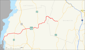
maint=VTrans
direction_a=West
starting_terminus=jct|state=NY|NY|9N|NY|22 via NY 910L in Crown Point, NY
junction=jct|state=VT|US|7 in New Haven
jct|state=VT|VT|116 in Bristol
direction_b=East
ending_terminus=jct|state=VT|VT|100 in Waitsfield
counties=Addison, Chittenden, Washington
previous_type=VT
previous_route=16
next_type=VT
next_route=18Vermont Route 17 is a convert|40.409|mi|km|3|sing=on long
state highway in westernVermont . The western terminus is at theNew York -Vermont state line on the Champlain Bridge in Chimney Point, where the route continues toNew York State Route 9N /New York State Route 22 inCrown Point, New York , as New York State Route 910L, an unsigned reference route. The eastern terminus is at VT 100 in Waitsfield.VT 17 was initially much shorter than it is today, encompassing only the
Lake Champlain -Addison portion of its routing upon assignment. It was extended in the late 1960s through theGreen Mountains to Waitsfield.Route description
The routing of VT 17 varies greatly on opposite sides of the Bristol town center. West of Bristol, the route passes through generally level terrain and connects multiple communities. East of Bristol, VT 17 is more mountainous and more rural in nature.
New York
The connector road to Vermont 17, New York State Route 910L (Bridge Road), begins at an intersection with
New York State Route 9N /New York State Route 22 concurrency inCrown Point, New York . Route 910L heads northward, intersecting with several local roads and passing to the east ofCrown Point State Historical Park before crossing over the Champlain Bridge into Vermont. [cite map|url=http://maps.google.com/maps?sourceid=navclient&ie=UTF-8&rlz=1T4ADBF_enUS232US232&q=from:+Bridge+Rd/RT-903+%4043.996560,+-73.454810+to:+RT-903+%4044.032780,+-73.423170&um=1&sa=N&tab=il|publisher=Google Maps |accessdate=2008-03-16|title=Overview map of NY 910L/NY 903]West of Bristol
VT 17 begins on the Champlain Bridge at the
New York -Vermont state line, continuing the path of Bridge Road (NY 910L) through Addison County. Shortly after reaching the eastern shore ofLake Champlain , VT 17 intersects VT 125 adjacent to theChimney Point State Historical Site at Chimney Point. The route continues northward along the lakeshore for roughly convert|2|mi|km|0 (passingD.A.R. State Park ) before turning eastward toward Addison.cite map|title=Official Vermont state map - Vermont Road Map & Guide to Vermont Attractions|year=2007|publisher=State of Vermont |accessdate=2008-02-19]In the center of Addison, situated convert|6|mi|km|0 from Lake Champlain, VT 17 intersects VT 22A. VT 17 continues east from Addison, crossing over the
Otter Creek and intersecting VT 23 near Weybridge prior to curving to the northeast toward Waltham. Midway between Waltham and New Haven, VT 17 briefly overlaps U.S. Route 7, then continues eastward through New Haven to Bristol. Prior to entering the town center, VT 17 intersects VT 116. VT 116 turns east onto VT 17, joining the route through Bristol along Main Street.East of Bristol
Outside of Bristol, VT 17 and VT 116 are joined by the
New Haven River , here marking the northern boundary of theGreen Mountain National Forest . The roadway and the waterway head east, following a winding route through theGreen Mountains . When the New Haven splits off to the southeast shortly afterward, VT 17 and VT 116 continue north alongBaldwin Creek up to the point where VT 17 and VT 116 split. While VT 116 continues north alongBeaver Brook , VT 17 remains in the vicinity of Baldwin Creek as it heads northeast through the Green Mountains.Midway between Bristol and Waitsfield, VT 17 intersects Gore Road, a local road that leads to eastern Burlington convert|15|mi|km|0 to the north. The route crosses into Chittenden County, as well as the
Camel's Hump State Park , shortly afterward. The route leaves Chittenden County and passes into Washington County convert|2|mi|km|0 later upon traversing theAppalachian Gap , a mountain pass located to the north of Mount Ellen. East of the gap, VT 17 continues through the eastern Green Mountains for convert|6|mi|km|0 to Waitsfield, where it terminates at VT 100.History
The road connecting the ferry landing at Chimney Point to the town center of Addison was designated in 1927 as Vermont Route F-7. The ferry crossed
Lake Champlain into Port Henry. ["Official Automobile Blue Book, Vol.1", (Automobile Blue Books Inc., Chicago, 1926 and 1927). The 1926 edition shows the Addison-Chimney Point route as unnumbered while the 1927 edition shows the route numbered as F-7.] In 1929, the Champlain Bridge opened, connecting Chimney Point to Crown Point. [National Bridge Inventory , a database compiled by theUnited States Department of Transportation Federal Highway Administration , available at www.nationalbridges.com. Accessed2008-02-19 .] By the beginning of 1930, Route F-7 was renumbered to Route 17, which began at the New York state line and ended in Addison at Route 30A (nowVermont Route 22A )."Automobile Legal Association (ALA) Automobile Green Book", 1930/31 edition, (Scarborough Motor Guide Co., Boston, 1930)] In 1933, Vermont Route 17 was added to the state highway system, including an eastern extension toU.S. Route 7 in New Haven. Prior to that, maintenance of the road was under control of the towns.cite web|url=http://www.aot.state.vt.us/Planning/Documents/Mapping/Publications/History_RtLogNotes.pdf|title=State Highways History, in Route Order with Route Log Notes|publisher=Vermont Agency of Transportation , Policy and Planning Division - Mapping|date=2007-10-05 |format=PDF|accessdate=2008-02-19] As part of the 1935 state highway expansion, additional mileage was added to Vermont Route 17, which was extended convert|4.3|mi|km toVermont Route 116 in Bristol. [cite web|url=http://www.aot.state.vt.us/planning/documents/mapping/publications/History_Details_1931_1935.pdf|title=State Highways History, Details of the Original 1931 1000-mile Addition and the 1935 700-mile Addition|publisher=Vermont Agency of Transportation , Policy and Planning Division - Mapping|date=2007-10-05 |format=PDF|accessdate=2008-02-19]In 1936, a convert|2.7|mi|km portion of the "McCullough Turnpike" in Fayston, which was chartered in 1933 but proved to be unprofitable, [ [http://books.google.com/books?id=LkqfmiSLNzIC&pg=PA146 O.D. Gutfreund, "Twentieth-Century Sprawl: Highways and the Reshaping of the American Landscape"] , (Oxford University Press, New York, 2004), p.146] was deeded back to the state of Vermont and renamed to McCullough State Highway. The road was paved during the period of 1936 and 1940. The rest of the McCullough Turnpike to
Vermont Route 100 in Waitsfield became part of the state highway system in 1956. In 1965, the state legislature authorized the extension of Vermont Route 17 from Bristol to Starksboro to connect with McCullough State Highway. The VT 17 designation was extended east along McCullough State Highway by 1972. [Cite map | publisher =United States Geological Survey | title = Bristol Quadrangle - Vermont - Addison Co. | year = 1963 | scale = 1 : 24,000 | series = 7.5 Minute Series (Topographic)] [cite map|url=http://terraserver-usa.com/image.aspx?T=2&S=15&Z=18&X=101&Y=762&W=3&qs=%7cbristol%7cvt%7c|title=Lake Champlain, New York; Canada; Vermont Quadrangle|publisher=United States Geological Survey |year=1972|scale=1 : 250,000|series=Eastern United States 1:250,000|accessdate=2007-12-23]The short connector between VT 17 and the NY 9N/NY 22 overlap in
Crown Point, New York , was originally designated as part of NY 8 in the early 1930s. ["Automobile Legal Association (ALA) Automobile Green Book", 1930/31 and 1931/32 editions, (Scarborough Motor Guide Co., Boston, 1930 and 1931). The 1930/31 edition shows New York state routes prior to the 1930 renumbering] [cite map |title=Road Map & Historical Guide - New York |publisher=Sun Oil Company |year=1935 |cartography=Rand McNally and Company ] NY 8 was truncated to its present northern terminus in |year=1980|scale=1:24,000|series=Eastern United States 1:24,000|accessdate=2008-02-02] prior to being renumbered to its current designation of NY 910L.Major intersections
Also shown is VT 17's continuation into New York as NY 910L.NYint
county=Essex
cspan=2
location=Crown Point
lspan=2
mile=0.00
road=jct|state=NY|NY|9N|NY|22
-
rowspan=2|4.11
0.000!rowspan=2 colspan=2|New York -Vermont state line; roadway becomes VT 17 eastbound and NY 910L westbound
-
rowspan=8|Addison
rowspan=3|Addison
-VTint
mile=0.315
road=
notes=Western terminus of VT 125VTint
mile=8.377
road=VTint
mile=11.140
road=
location=Weybridge
notes=Western terminus of VT 23VTint
type=mplex
mile=15.735
road= north
location=New Haven
lspan=2
notes=Northern terminus of concurrencyVTint
type=mplex
mile=15.849
road= south
notes=Southern terminus of concurrencyVTint
type=mplex
mile=20.189
road= south
location=Bristol
lspan=2
notes=Western terminus of concurrencyVTint
type=mplex
mile=24.503
road= north
notes=Eastern terminus of concurrencyVTint
county=Washington
mile=40.409
road=
location=WaitsfieldReferences

Wikimedia Foundation. 2010.