- Marysvale, Utah
-
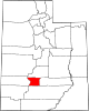
Marysvale, Utah — Town — Marysvale post office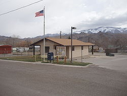 Location of Marysvale, Utah
Coordinates: 38°26′51″N 112°13′58″W / 38.4475°N 112.23278°WCoordinates: 38°26′51″N 112°13′58″W / 38.4475°N 112.23278°W Country United States State Utah County Piute Settled 1863 Incorporated 1913 Area – Total 15.1 sq mi (39.1 km2) – Land 15.1 sq mi (39.1 km2) – Water 0.0 sq mi (0.0 km2) Elevation 5,863 ft (1,787 m) Population (2000) – Total 381 – Density 25.2/sq mi (9.7/km2) Time zone Mountain (MST) (UTC-7) – Summer (DST) MDT (UTC-6) ZIP code 84750 Area code(s) 435 FIPS code 49-48610[1] GNIS feature ID 1443220[2] Marysvale is a town in Piute County, Utah, United States. The population was 381 at the 2000 census. Marysvale is a trail head for the Paiute ATV Trail.
Contents
Geography
Marysvale is located at 38°26′51″N 112°13′58″W / 38.4475°N 112.23278°W (38.447585, -112.232763).[3]
According to the United States Census Bureau, the town has a total area of 15.1 square miles (39.1 km²), of which, 15.1 square miles (39.1 km²) of it is land and 0.07% is water.
Demographics
Historical populations Census Pop. %± 1890 259 — 1900 435 68.0% 1910 495 13.8% 1920 624 26.1% 1930 471 −24.5% 1940 626 32.9% 1950 520 −16.9% 1960 354 −31.9% 1970 289 −18.4% 1980 359 24.2% 1990 364 1.4% 2000 381 4.7% As of the census[1] of 2000, there were 381 people, 149 households, and 113 families residing in the town. The population density was 25.2 people per square mile (9.7/km²). There were 222 housing units at an average density of 14.7 per square mile (5.7/km²). The racial makeup of the town was 98.43% White, 0.79% from other races, and 0.79% from two or more races. Hispanic or Latino of any race were 2.10% of the population.
There were 149 households out of which 27.5% had children under the age of 18 living with them, 63.8% were married couples living together, 8.7% had a female householder with no husband present, and 23.5% were non-families. Of the 149 households, 8 are unmarried partner households: 2 heterosexual, 2 same-sex male, and 4 same-sex female. 21.5% of all households were made up of individuals and 9.4% had someone living alone who was 65 years of age or older. The average household size was 2.56 and the average family size was 2.96.
In the town the population was spread out with 24.7% under the age of 18, 6.6% from 18 to 24, 20.2% from 25 to 44, 31.2% from 45 to 64, and 17.3% who were 65 years of age or older. The median age was 44 years. For every 100 females there were 96.4 males. For every 100 females age 18 and over, there were 91.3 males.
The median income for a household in the town was $31,875, and the median income for a family was $35,417. Males had a median income of $33,125 versus $21,667 for females. The per capita income for the town was $12,715. About 9.1% of families and 11.8% of the population were below the poverty line, including 14.8% of those under age 18 and 2.9% of those age 65 or over.
Actress Marie Windsor was born in Marysvale in 1919.
References
- ^ a b "American FactFinder". United States Census Bureau. http://factfinder.census.gov. Retrieved 2008-01-31.
- ^ "US Board on Geographic Names". United States Geological Survey. 2007-10-25. http://geonames.usgs.gov. Retrieved 2008-01-31.
- ^ "US Gazetteer files: 2010, 2000, and 1990". United States Census Bureau. 2011-02-12. http://www.census.gov/geo/www/gazetteer/gazette.html. Retrieved 2011-04-23.
External links
Municipalities and communities of Piute County, Utah Towns Circleville | Junction | Kingston | Marysvale
Unincorporated
communitiesGhost towns Alunite | Kimberly
Categories:- Populated places in Piute County, Utah
- Towns in Utah
- Populated places established in 1863


Wikimedia Foundation. 2010.