- Orange Grove, Texas
-
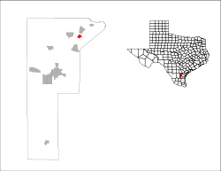
City of Orange Grove — City — Location in the state of Texas Coordinates: 27°57′22″N 97°56′21″W / 27.95611°N 97.93917°WCoordinates: 27°57′22″N 97°56′21″W / 27.95611°N 97.93917°W Country United States State Texas County Jim Wells Government – Mayor Area – Total 1.1 sq mi (2.8 km2) – Land 1.1 sq mi (2.8 km2) – Water 0.0 sq mi (0.0 km2) Elevation 194 ft (59 m) Population (2000 U.S. Census) – Total 1,288 – Density 1,192.6/sq mi (460.5/km2) Time zone CST (UTC-6) – Summer (DST) CDT (UTC-5) ZIP code 78372 Area code(s) 361 FIPS code 48-54168[1] GNIS feature ID 1343303[2] Orange Grove is a city in Jim Wells County, Texas, United States. The population was 1,288 at the 2000 census.
Contents
Geography
Orange Grove is located at 27°57′22″N 97°56′21″W / 27.95611°N 97.93917°W (27.956224, -97.939077).[3]
According to the United States Census Bureau, the city has a total area of 1.1 square miles (2.8 km2), all of it land.
Demographics
As of the census[1] of 2000, there were 1,288 people, 473 households, and 339 families residing in the city. The population density was 1,192.6 people per square mile (460.5/km²). There were 515 housing units at an average density of 476.9 per square mile (184.1/km²). The racial makeup of the city was 90.37% White, 0.31% African American, 0.47% Asian, 0.16% Pacific Islander, 8.07% from other races, and 0.62% from two or more races. Hispanic or Latino of any race were 50.31% of the population.
There were 473 households out of which 40.2% had children under the age of 18 living with them, 55.0% were married couples living together, 13.3% had a female householder with no husband present, and 28.3% were non-families. 27.3% of all households were made up of individuals and 16.7% had someone living alone who was 65 years of age or older. The average household size was 2.72 and the average family size was 3.33.
In the city the population was spread out with 30.8% under the age of 18, 8.5% from 18 to 24, 26.6% from 25 to 44, 21.2% from 45 to 64, and 12.9% who were 65 years of age or older. The median age was 33 years. For every 100 females there were 83.5 males. For every 100 females age 18 and over, there were 81.8 males.
The median income for a household in the city was $32,981, and the median income for a family was $42,500. Males had a median income of $32,500 versus $22,105 for females. The per capita income for the city was $15,082. About 13.6% of families and 16.5% of the population were below the poverty line, including 22.0% of those under age 18 and 14.1% of those age 65 or over.
N.A.L.F
The BRAC decision to close Chase Field led to an increase in Pilot Training Rate (PTR) and the physical number of aircraft stationed aboard NAS Kingsville. Currently 70 T-45 trainer aircraft have arrived. In recognition of the increased congestion at Kingsville, the Navy made a significant investment in improving the facilities and capabilities of the Auxiliary Landing Field (ALF) at Orange Grove. The terminal airspace at Kingsville was expanded to include Orange Grove and the ALF serves as an overflow relief from the primary airfield.
Hunting and fishing aboard the station, NALF Orange Grove and Escondido Ranch is authorized in accordance with station directives and state and federal laws. Naval Air Station (NAS) Kingsville's gesture is a great example of how the United States Navy gives a hoot. Located in Kingsville, TX, NAS Kingsville has decided to play seasonal host to the burrowing owl. The South Texas Naval air station, in a partnership with the U.S. Geological Survey's Texas Gulf Coast Field Research Station, the Coastal Bend Bays & Estuaries Program, Texas A&M-Corpus Christi and the Coastal Bend Ambassadors, will offer an open field with artificial burrows for the burrowing owls, which are anticipated to stay there over the winter, beginning in October. The Naval Auxiliary Landing Field (NALF) in Orange Grove, TX, also will have artificial burrows. NAS Kingsville has 18 artificial burrows, as does NALF Orange Grove. The burrows are done in three groups of six sets, with each group being about 100 yards (91 m) apart.
Education
The City of Orange Grove is served by the Orange Grove Independent School District.
References
- ^ a b "American FactFinder". United States Census Bureau. http://factfinder.census.gov. Retrieved 2008-01-31.
- ^ "US Board on Geographic Names". United States Geological Survey. 2007-10-25. http://geonames.usgs.gov. Retrieved 2008-01-31.
- ^ "US Gazetteer files: 2010, 2000, and 1990". United States Census Bureau. 2011-02-12. http://www.census.gov/geo/www/gazetteer/gazette.html. Retrieved 2011-04-23.
Municipalities and communities of Jim Wells County, Texas Cities Village CDPs Unincorporated
communitiesAlfred | Ben Bolt | Bentonville | Casa Blanca | La Gloria | Palito Blanco | Rancho de la Parita | Springfield
Footnotes ‡This populated place also has portions in an adjacent county or counties
Categories:- Cities in Texas
- Populated places in Jim Wells County, Texas
- Populated places in Texas with Hispanic majority populations
Wikimedia Foundation. 2010.


