- Owl Ranch-Amargosa, Texas
-
Owl Ranch-Amargosa, Texas — CDP — Location of Owl Ranch-Amargosa, Texas
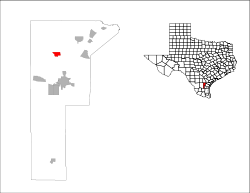
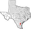
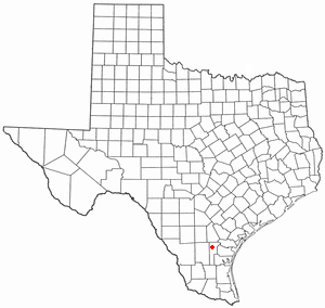
Coordinates: 27°53′22″N 98°6′32″W / 27.88944°N 98.10889°WCoordinates: 27°53′22″N 98°6′32″W / 27.88944°N 98.10889°W Country United States State Texas County Jim Wells Area – Total 2.3 sq mi (5.9 km2) – Land 2.3 sq mi (5.9 km2) – Water 0.0 sq mi (0.0 km2) Population (2000) – Total 527 – Density 233.3/sq mi (90.1/km2) Time zone Central (CST) (UTC-6) – Summer (DST) CDT (UTC-5) FIPS code 48-54510[1] Owl Ranch-Amargosa is a census-designated place (CDP) in Jim Wells County, Texas, United States. The population was 527 at the 2000 census.
Contents
Geography
Owl Ranch-Amargosa is located at 27°53′22″N 98°6′32″W / 27.88944°N 98.10889°W (27.889475, -98.109000)[2]. This community is locally known as Tecalote (Mexican word for owl).
According to the United States Census Bureau, the CDP has a total area of 2.3 square miles (6.0 km2), of which, 2.3 square miles (6.0 km2) of it is land and 0.44% is water.
Demographics
As of the census[1] of 2000, there were 527 people, 157 households, and 127 families residing in the CDP. The population density was 233.3 people per square mile (90.0/km²). There were 206 housing units at an average density of 91.2/sq mi (35.2/km²). The racial makeup of the CDP was 78.56% White, 0.57% African American, 0.38% Native American, 18.22% from other races, and 2.28% from two or more races. Hispanic or Latino of any race were 93.93% of the population.
There were 157 households out of which 44.6% had children under the age of 18 living with them, 56.1% were married couples living together, 17.8% had a female householder with no husband present, and 18.5% were non-families. 15.9% of all households were made up of individuals and 3.8% had someone living alone who was 65 years of age or older. The average household size was 3.36 and the average family size was 3.74.
In the CDP the population was spread out with 38.3% under the age of 18, 9.1% from 18 to 24, 27.9% from 25 to 44, 16.3% from 45 to 64, and 8.3% who were 65 years of age or older. The median age was 27 years. For every 100 females there were 104.3 males. For every 100 females age 18 and over, there were 104.4 males.
The median income for a household in the CDP was $16,875, and the median income for a family was $18,750. Males had a median income of $21,797 versus $12,647 for females. The per capita income for the CDP was $5,365. About 38.4% of families and 36.9% of the population were below the poverty line, including 35.4% of those under age 18 and 27.8% of those age 65 or over.
Education
Owl Ranch-Amargosa is served by the Alice Independent School District.
References
- ^ a b "American FactFinder". United States Census Bureau. http://factfinder.census.gov. Retrieved 2008-01-31.
- ^ "US Gazetteer files: 2010, 2000, and 1990". United States Census Bureau. 2011-02-12. http://www.census.gov/geo/www/gazetteer/gazette.html. Retrieved 2011-04-23.
Municipalities and communities of Jim Wells County, Texas Cities Alice | Orange Grove | Premont | San Diego‡
Village CDPs Alfred-South La Paloma | Alice Acres | Coyote Acres | K-Bar Ranch | Loma Linda East | Owl Ranch-Amargosa | Rancho Alegre | Sandia | Westdale
Unincorporated
communitiesAlfred | Ben Bolt | Bentonville | Casa Blanca | La Gloria | Palito Blanco | Rancho de la Parita | Springfield
Footnotes ‡This populated place also has portions in an adjacent county or counties
Categories:- Populated places in Jim Wells County, Texas
- Census-designated places in Texas
- Populated places in Texas with Hispanic majority populations


Wikimedia Foundation. 2010.