- Ashmont (MBTA station)
Infobox Station
name= Ashmont Station
image_size=300
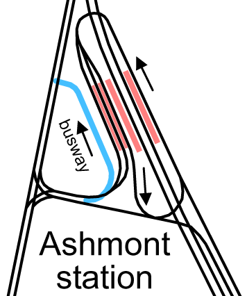
image_caption=Original configuration, with streetcar loop (later bus loop) and 1929-added busway
address=1900 Dorchester Avenue
at 200 Ashmont StreetDorchester, Massachusetts
line=rail color box|system=MBTA|line=Redrail color box|system=MBTA|line=Mattapan
other=
platform=
parking=
bicycle=eight spaces
passengers=
pass_year=
pass_percent=
opened=September 1 ,1928 (Red Line)August 26 ,1929 (Ashmont-Mattapan Line)
"under construction as of August 2005"
rebuilt=to be completed 2009
ADA=Yes
code=
owned=Massachusetts Bay Transportation Authority
zone=
services= s-rail|title=MBTA s-line|system=MBTA|line=Red|branch=Ashmont|previous=Shawmut|next= s-line|system=MBTA|line=Mattapan|previous=|next=Cedar GroveAshmont is located on the Red Line in
Dorchester, Massachusetts . It opened onSeptember 1 ,1928 , and is the subway terminal for the Red Line's Dorchester Branch. Ashmont is also the terminus of theLight rail Ashmont-Mattapan High Speed Line , which loops around on each side of the station, with platforms between the sets of tracks.History
The first Ashmont Station was a simple building along the original Shawmut Branch of the
Old Colony Railroad , which opened in 1872. That was when steam locomotives powered the passenger trains that continued into Boston with a stop at Fields Corner. The current intermediate Shawmut Station was not created as a train stop until the Shawmut Branch of the steam railroad was adapted to electrified subway service in the late 1920s and placed underground as it approached Ashmont Station.When first built in 1928, no buses served the station; all lines ran
streetcar s. Specifically, the followingBoston Elevated Railway streetcar lines operated to Ashmont (using post-1942 numbers), unloading on the east side and loading on the two west tracks on the west side:
*MBTABus|22 Dudley via Talbot Avenue
*MBTABus|23 Dudley via Washington Street, Dorchester
*MBTABus|27 Mattapan Station via River St.Eastern Massachusetts Street Railway cars to Brockton also used the station.Two streetcar lines serving the area west of Ashmont were
bustituted soon after opening, later becoming the MBTABus|25 and MBTABus|26 buses. They were rerouted to Ashmont for faster access to downtown. A new busway was built on the west side of the station in 1929; this has since been connected to the old streetcar ramps. The first section of theMattapan High Speed Line (originally MBTABus|28) also opened in 1929, serving the easternmost track on the west side.The Eastern Massachusetts Street Railway line converted to bus in 1932, using the busway. The MBTABus|27 was bustituted in 1933, and a new route (MBTABus|24, renumbered MBTABus|12 ca. 1967) serving the area east of the station was also added. Additionally the Eastern Mass started running buses over what are now the MBTABus|215 and MBTABus|217 routes.
The ramps were paved, and in 1949 the
Trolleybus replaced the MBTABus|22 and MBTABus|23 lines.Reconstruction
In 2005, the MBTA awarded a $35.2 million contract for the complete reconstruction of the 75 year old Ashmont Station. As of September 2007, razing of the station was complete. Construction crews are rebuilding the station from the ground up, with the completion projected in 2009. [http://mbta.com/about_the_mbta/news_events/?id=15779&month=&year=] Trolley service was interrupted for 18 months, but was restored in December 2007. [Cite news|title=Commuter Rail service is back after a barge hits a bridge|publisher=
WHDH-TV |date=December 22 2007 |url=http://www3.whdh.com/news/articles/local/BO69564/|accessdate=2007-12-24] Highlights of the project include:Cite web|url=http://www.mbta.com/about_the_mbta/t_projects/?id=980|title=MBTA > Ashmont Station Renovation|publisher=MBTA|accessdate=2007-09-30] [Cite web|url=http://ashmont.typepad.com/ashmont_t/files/ashmont_bidresponsesdetail.pdf|title=Bid Responses|author=MBTA|publisher=Ashmont Station Community Website|format=PDF|accessdate=2007-09-30]* New platforms and a viaduct for the trolley service to Mattapan
* Two new lobbies with access at the station
* An elevated busway that is level with the new lobbies
* Public access over the subway tunnel to Peabody Square
* Three new elevators and two new escalators
* CCTV security cameras and significantly enhanced lighting
* Charlie Card automated fare vending machines and fare gatesThe station construction includes of a first-of-its-kind
transit oriented development (TOD) on the station site. The 116 units of mixed income housing represent the state, city, MBTA, community and a private developer's combined effort to provide housing adjacent to rapid transit, thereby reducing automobile usage. The housing project, developed by Trinity Financial will be completed in the Spring of 2008. [Cite news|first=Steve|last=Adams|title=PEABODY SQUARE - Hub developer reclaiming old, beaten-up subway station to create vibrant, 24-hour community
url=http://www.patriotledger.com/articles/2007/06/28/business/biz01.txt|work=The Patriot Ledger |date=2007-06-28 |accessdate=2007-09-30]Accessibility
The station is
wheelchair -accessible. SeeMBTA accessibility .Bus Connections
MBTA bus lines
*MBTABus|18 - Andrew Sta. via Fields Corner
*MBTABus|21 - Forest Hills Sta. via Morton St.
*MBTABus|22 - Ruggles Sta. via Talbot Ave.
*MBTABus|23 - Ruggles Sta. via Washington St.
*MBTABus|27 - Mattapan Sta. via River St.
*MBTABus|215 - Quincy Center Sta. via W. Quincy
*MBTABus|240 - Avon Square or Holbrook/Randolph Commuter Rail Sta.Other bus lines
*BAT12 - Brockton (operated by Brockton Area Transit)References
* [http://www.mbta.com/schedules_and_maps/subway/lines/stations/?stopId=15481&lat=42.284219&lng=-71.063229 MBTA - Ashmont Station] . MBTA. Retrieved on
2007-09-30 .
* [http://world.nycsubway.org/us/boston/red/mbta-red-ashmont.html nycsubway.org - MBTA Red Line: Ashmont] . Retrieved on2007-09-30 .External links
* [http://www.mbta.com/schedules_and_maps/subway/lines/stations/?stopId=15481&lat=42.284219&lng=-71.063229 MBTA - Ashmont Station (Red Line)]
* [http://world.nycsubway.org/us/boston/red/mbta-red-ashmont.html nycsubway.org - MBTA Red Line: Ashmont]
* [http://www.ashmont.typepad.com Ashmont Station Community Website (Red Line)]
* [http://www.c7a.com/Portfolio/transportation/mbta_ashmont.asp?pos=0 Cambridge Seven Associates project page]
Wikimedia Foundation. 2010.