Fields Corner (MBTA station)

Fields Corner (MBTA station)

Infobox Station
name=Fields Corner
type=MBTA subway station


image_size=
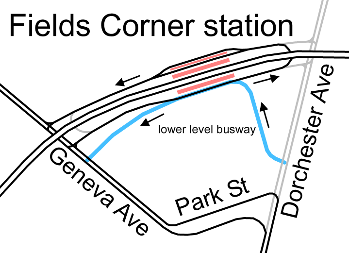
image_caption=Original configuration of Fields Corner with streetcar loop and separate busway
address=Dorchester Avenue & Charles Avenue
Dorchester, MA
coordinates=
line=
other=
structure=
platform=2 side platforms
depth=
levels=
tracks=2
parking=
bicycle=
baggage_check=
opened=5 November 1927
closed=
rebuilt=
electrified=
ADA=yes
code=
owned=MBTA
zone=
former=
passengers=
pass_year=
pass_percent=
pass_system=
mpassengers=
services=
map_locator=

Fields Corner is a station on the rapid transit Red Line at Fields Corner in Dorchester, Massachusetts. It opened on November 5, 1927, serving as the south end of the line for about a year. In addition to the two rapid transit platforms, one on each side of the line, there were streetcar tracks on each side, with the departing tracks at the north (railroad west) side split into two, and a bus loop under the south (east) track. Free transfers were available between all modes. With buses a paper transfer was required.

The lower level busway was later closed, and all buses (and trackless trolleys) were routed to the upper level. The upper level busways were closed in the 2000s for reconstruction.

A new Fields Corner station entrance lobby opened on Friday, December 22, 2006. After a ribbon-cutting ceremony at 10:05 am that day, Fields Corner became the final station to be converted to use the CharlieCard-based automated fare collection system. A complete station renovation was completed on September 23, 2008. [http://mbta.com/about_the_mbta/news_events/?id=15779&month=&year=]

Bus connections

*MBTABus|15 Ruggles Sta. via Uphams Corner & Kane Sq. (late evenings only)
*MBTABus|17 Andrew Station via Uphams Corner & Edward Everett Square
*MBTABus|18 Ashmont Station - Andrew Station via Fields Corner Station
*MBTABus|19 Ruggles Sta. via Grove Hall & Dudley Station
*MBTABus|201 Fields Corner - Fields Corner or No. Quincy Station via Neponset Ave. to Adams St.
*MBTABus|202 Fields Corner - Fields Corner or No. Quincy Station via Adams St. to Neponset Ave.
*MBTABus|210 Quincy Center Sta. via Hancock St., No. Quincy Sta. & Neponset Ave.

Accessibility

Fields Corner is wheelchair accessible. See MBTA accessibility.

External links

* [http://www.mbta.com/schedules_and_maps/subway/lines/stations/?stopId=11781 MBTA - Fields Corner Station (Red Line)]
* [http://world.nycsubway.org/us/boston/red/mbta-red-fieldscorner.html nycsubway.org - MBTA Red Line: Fields Corner]
* [http://www.c7a.com/Portfolio/transportation/mbta_fields_corner.asp?pos=0 Cambridge Seven Associates project page]


Wikimedia Foundation. 2010.

Игры ⚽ Поможем решить контрольную работу

Look at other dictionaries:

  • North Quincy (MBTA station) — NORTH QUINCY The Hancock Street entrance to the T station and its associated parking lot Station statistics Address …   Wikipedia

  • Quincy Center (MBTA station) — Infobox Station name=Quincy Center image size= image caption= address=1300 Hancock Street at Washington Street Quincy, MA 02169 coordinates = coord|42|15|3.16|N|71|00|17.27|W|type:railwaystation line=rail color box|system=MBTA|line=Redrail color… …   Wikipedia

  • Savin Hill (MBTA station) — Savin Hill Station, which serves the nearby neighborhood of Savin Hill and adjacent areas in Dorchester, is located on 215 Savin Hill Avenue adjacent to Sydney Street in Dorchester, Massachusetts, just outside of downtown Boston and three stops… …   Wikipedia

  • Ashmont (MBTA station) — Infobox Station name= Ashmont Station image size=300 image caption=Original configuration, with streetcar loop (later bus loop) and 1929 added busway address=1900 Dorchester Avenue at 200 Ashmont Street Dorchester, Massachusetts line=rail color… …   Wikipedia

  • Ruggles (MBTA station) — Infobox Station name=Ruggles image size=250 image caption=Ruggles station platform. The commuter rail tracks are on the opposite side of the fence. address=Ruggles and Tremont Streets, Boston coordinates = coord|42.3362|… …   Wikipedia

  • Museum of Fine Arts (MBTA station) — MUSEUM OF FINE ARTS A train at the Museum of Fine Arts Station Station statistics …   Wikipedia

  • Kenmore (MBTA station) — Infobox Station name=Kenmore image size=300 image caption=Entrance to Kenmore Station address=500 Commonwealth Avenue @ One Brookline Avenue, Boston coordinates = coord|42|20|56.13|N|71|5|44.19|W|display=inline,title|type:railwaystation line=… …   Wikipedia

  • List of MBTA bus routes — The Massachusetts Bay Transportation Authority bus division operates the following bus routes, in the U.S., many of which are descendants of streetcar routes of the Boston Elevated Railway or a suburban company.pecial routesThe Silver Line… …   Wikipedia

  • Red Line (MBTA) — RED LINE An MBTA Red Line train composed of #3 Red Line stock leaving Charles/MGH station bound for Alewife, going over the Longfellow Bridge …   Wikipedia

  • Urban Ring Project (MBTA) — The Urban Ring is a project of the Massachusetts Bay Transportation Authority and the Commonwealth of Massachusetts, to develop new public transportation routes that would provide improved circumferential connections among many existing transit… …   Wikipedia

Share the article and excerpts

Direct link
Do a right-click on the link above
and select “Copy Link”