North Quincy (MBTA station)

North Quincy (MBTA station)
NORTH QUINCY
NQ T rear.jpg
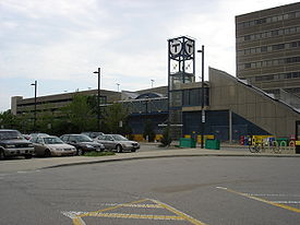
The Hancock Street entrance to the T station and its associated parking lot
Station statistics
Address East Squantum Street between
Newport Avenue and Hancock Street
North Quincy, Massachusetts
Coordinates 42°16′33″N 71°01′49″W / 42.2758°N 71.0302°W / 42.2758; -71.0302Coordinates: 42°16′33″N 71°01′49″W / 42.2758°N 71.0302°W / 42.2758; -71.0302
Lines
Platforms 1 island platform
Tracks 2
Parking 1,200 spaces
Bicycle facilities 43 spaces
Other information
Opened September 1, 1971
Accessible Handicapped/disabled access
Owned by Massachusetts Bay Transportation Authority
Services
Preceding station   MBTA   Following station
toward Alewife
Red Line
toward Braintree

North Quincy is a station on the Red Line subway at East Squantum Street between Hancock Street and Newport Avenue in Quincy, Massachusetts, and serves North Quincy High School, the State Street Bank complex, and the North Quincy and Montclair neighborhoods. Its other facilities include bus connections at street level and a 1,200-space parking lot. It is the northernmost station on the Braintree Branch of the Red Line, and was built in 1971.

Bus connections

Accessibility

North Quincy station is wheelchair accessible. See MBTA accessibility.

External links

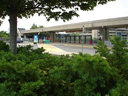
The East Squantum Street entrance and bus stop

Wikimedia Foundation. 2010.

Игры ⚽ Поможем решить контрольную работу

Look at other dictionaries:

  • North Quincy — may refer to one of the following places: North Quincy (Quincy, Massachusetts) a neighborhood in Quincy, Massachusetts. North Quincy (MBTA station) a station on the Red line subway North Quincy High School North Quincy, Illinois an unincorporated …   Wikipedia

  • Quincy Center (MBTA station) — Infobox Station name=Quincy Center image size= image caption= address=1300 Hancock Street at Washington Street Quincy, MA 02169 coordinates = coord|42|15|3.16|N|71|00|17.27|W|type:railwaystation line=rail color box|system=MBTA|line=Redrail color… …   Wikipedia

  • North Quincy (Quincy, Massachusetts) — North Quincy is a neighborhood of Quincy, Massachusetts. It is separated from the city of Boston by the Neponset River, and borders the Quincy neighborhoods of Squantum, Montclair and Wollaston. It contains the smaller neighborhoods of Atlantic… …   Wikipedia

  • JFK/UMass (MBTA station) — JFK/UMASS JFK/UMASS …   Wikipedia

  • Government Center (MBTA station) — GOVERNMENT CENTER GOVERNMENT CENTER Government Center headh …   Wikipedia

  • Haymarket (MBTA station) — Infobox Station name= Haymarket image size= image caption=Green Line platform at Haymarket address=Congress Avenue at New Sudbury Street, Boston coordinates = coord|42.3633| 71.0582|display=inline,title|type:railwaystation line= other= platform=4 …   Wikipedia

  • Fields Corner (MBTA station) — Infobox Station name=Fields Corner type=MBTA subway station image size= image caption=Original configuration of Fields Corner with streetcar loop and separate busway address=Dorchester Avenue Charles Avenue Dorchester, MA coordinates= line= other …   Wikipedia

  • Quincy, Massachusetts — Infobox Settlement official name = Quincy, Massachusetts nickname = motto = imagesize = image caption = image mapsize = 250px map caption = Location in Norfolk County in Massachusetts mapsize1 = map caption1 = subdivision type = Country… …   Wikipedia

  • Quincy Point — city line, on the north by Town River and on the south by Quincy Avenue. The area altitude averages about convert|30|ft|m|sigfig=2 above sea level. The population of this neighborhood in 2000 was 11,414. [cite web… …   Wikipedia

  • MBTA accessibility — Handicap accessibility on the Massachusetts Bay Transportation Authority (MBTA or the T ) system is limited but improving. As is true for most mass transit systems, much of the Boston subway and commuter rail lines were built before wheelchair… …   Wikipedia

Share the article and excerpts

Direct link
Do a right-click on the link above
and select “Copy Link”