- Dudley Square (MBTA station)
-
DUDLEY SQUARE 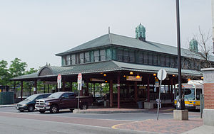
Station statistics Address Washington St at Dudley St, Roxbury Coordinates 42°19′45″N 71°05′03″W / 42.3292°N 71.0842°WCoordinates: 42°19′45″N 71°05′03″W / 42.3292°N 71.0842°W Lines Parking none Bicycle facilities none Other information Opened June 10, 1901 (Washington Street Elevated)
July 20, 2002(Silver Line)Closed April 30, 1987 {Washington Street Elevated) Accessible 
Owned by Massachusetts Bay Transportation Authority Services Preceding station MBTA Following station Terminus Silver Line toward South StationSilver Line toward Downtown Crossing Looking north at the former train station's northbound platforms, with the streetcar loops on each side.
Dudley Square (originally Dudley Street or Dudley) is a ground-level bus depot in Dudley Square, Roxbury, Boston, Massachusetts, USA, served by local buses of the Massachusetts Bay Transportation Authority and their Silver Line bus rapid transit service. In addition to the Silver Line it serves the 1, 8, 14, 15, 19, 23, 25, 28, 41, 42, 44, 45, 47, 66, 170, and 171 bus lines.
Contents
History
Dudley Station formerly served Orange Line trains on the Washington Street Elevated, with two elevated streetcar loops and additional service on the ground level.
The Boston Elevated Railway opened the Washington Street Elevated on June 10, 1901, terminating at Dudley. Many streetcar routes that had operated to downtown, some into the Tremont Street Subway, now terminated at the loops at Dudley, where cross-platform transfers were available to elevated trains.
The el was extended south on November 22, 1909, reaching its maximum distance, Forest Hills. The loop allowing trains to return downtown from Dudley was kept, and a new southbound platform was added (as both original platforms were on the northbound track).
Over the years, streetcar service to Dudley was replaced with buses.
Trains last ran to Dudley on April 30, 1987, and the relocated Orange Line opened on May 4, 1987. The old station sat untouched for a while, but was partially torn down and replaced with a simpler surface-level station which was made partly with new structures (platforms D, E, and F facing east-west, also known as the "Harvard side") and the preexisting el structure (platforms A, B, and C facing north-south, also known as the "Allston side"). The Silver Line, the MBTA's replacement service for the Washington Street Elevated, officially replaced the 49 bus route on July 20, 2002, and runs between Dudley and Downtown Crossing. On October 13, 2009, this service was re-designated the SL5 and a new SL 4 service was added that runs between Dudley and South Station, sharing most of the same route.
Accessibility
The station is fully accessible (see MBTA accessibility).
Future plans
Dudley Square Station is a proposed stop on the MBTA's planned Urban Ring Project.[1] The Urban Ring will be a Bus Rapid Transit (BRT) Line designed to connect the current MBTA Lines to reduce strain on the downtown stations.
External links
References
Categories:- Silver Line (MBTA)
- Bus transportation in the Boston area
- Bus stations in Massachusetts


Wikimedia Foundation. 2010.