Melnea Cass Boulevard (MBTA station)
- Melnea Cass Boulevard (MBTA station)
-
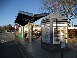
Melnea Cass Boulevard is a stop on the MBTA Phase I Silver Line located on Washington St at Melnea Cass Boulevard, in Roxbury.
Accessibility
The station is fully accessible (see MBTA accessibility).
External links
Wikimedia Foundation.
2010.
Look at other dictionaries:
Melnea Cass Boulevard — at Washington Street Melnea Cass Boulevard is a street in Boston, Massachusetts, located between Dudley Square in Roxbury and the South End. It is named after local community and civil rights activist Melnea Cass. There is also an MBTA Silver… … Wikipedia
Dudley Square (MBTA station) — DUDLEY SQUARE Station statistics Address Washington St at … Wikipedia
Urban Ring Project (MBTA) — The Urban Ring is a project of the Massachusetts Bay Transportation Authority and the Commonwealth of Massachusetts, to develop new public transportation routes that would provide improved circumferential connections among many existing transit… … Wikipedia
Key MBTA bus routes — Key bus routes in the Massachusetts Bay Transportation Authority (MBTA) system have high ridership and higher frequency standards than other bus lines. [http://www.mbta.com/uploadedFiles/About the T/T Projects/T Projects… … Wikipedia
Список станций MBTA — Карта линий и станций MBTA в 2003 году Ниже представлен список станций MBTA. Этот список включает в себя все станции метро, легкорельсового транспорта … Википедия
Morrissey Boulevard — William T. Morrissey Boulevard Morrissey Boulevard highlighted in red Maintained by: the Department of Conservation and Recreation Length … Wikipedia
List of stations on the MBTA subway — This is a list of stations on the MBTA subway in Boston, Massachusetts. Each line has its stations listed with the main line first followed by the branches. Stations that serve multiple lines are listed under all lines they serve. =Blue Line… … Wikipedia
Interstate 695 (Massachusetts) — Interstate 695 1955 Yellow Book plan for the Boston area showing the Inner Belt and related highways … Wikipedia
Massachusetts Route 203 — Morton Street redirects here. For the MBTA station, see Morton Street (MBTA station). Route 203 … Wikipedia
Kenmore Square — in Boston. The iconic Citgo sign is the main landmark of the square. Kenmore Square is a square in Boston, Massachusetts, United States, consisting of the intersection of several main avenues (including Beacon Street and Commonwealth Avenue) as… … Wikipedia